Antonito, Colorado: San Antonio Cut Down to Size
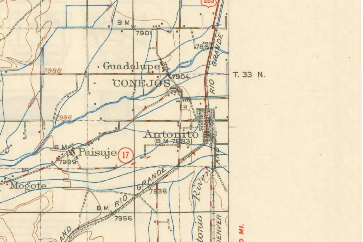
Antonito, Colorado, started out as a railroad town called San Antonio, and by 1881 its name had been shortened to a Spanish nickname. Antonito means “little Anthony,” and the Anthony in question was a river before he was a town.
A new town, already renamed
George Crofutt’s Grip-Sack Guide of Colorado, published in 1881, caught the town in the middle of the switch. Its entry reads “San Antonio—Recently changed to Antonito, Conejos county, is a new town, laid out and cared for by the Denver & Rio Grande Railway.”
Crofutt didn’t think much of the place yet. Besides a few stores, it had “a few poor hotels, and a large amount of saloons, gambling houses, and about 350 citizens.” The railroad had done better: “a fine depot building here, built of volcanic stone, excavated from the cuts on the San Juan Extension.” The town of Conejos sat “one and a half miles north” (2.4 km).
The guide doesn’t say why the name changed. You’ll find no explanation in the other sources here either, so treat any story about it with care.
Little Anthony and his river
The meaning is simpler. J. Frank Dawson’s 1954 Place Names in Colorado calls Antonito “Spanish for ‘little Anthony’” and says it was “named by the Denver and Rio Grande Railroad after San Antonio River in the vicinity.” If you check Crofutt’s own glossary of Spanish names, it translates San Antonio as “St. Anthony.”
The Geological Survey drew it in 1922 on its Conejos sheet. The San Antonio River runs just south and east of the town’s grid, close to where the railroad lines split.
Where two lines split
Antonito was a junction from the start. Crofutt called it the meeting point of “the New Mexican and San Juan Extensions” of the Denver & Rio Grande. Sixty years later the WPA’s 1941 guide to Colorado described the same layout: the town sat “at the junction of two lines of the Denver & Rio Grande Western Railroad, one south to Santa Fe, New Mexico, and the other—narrow-gauge—west to Durango.” By then it was “the chief shipping point for a large agricultural region,” with long potato sheds next to the station.
The USGS name file lists Antonito in Conejos County, with its location and no history note.
The railroad’s San Antonio kept its river’s name, just in a smaller size.
Quick answers
What does Antonito mean?
“Little Anthony” in Spanish, according to Dawson’s Place Names in Colorado (1954). He says the Denver & Rio Grande took the name from the San Antonio River nearby.
What was Antonito called before?
San Antonio. Crofutt’s 1881 guide lists the town under that name, “recently changed to Antonito.”
Who named Antonito, Colorado?
The Denver & Rio Grande Railroad, according to Dawson (1954). Crofutt (1881) says the railroad laid out the town.
Key dates
- 1881Crofutt's guide lists San Antonio, "recently changed to Antonito," as a new Denver & Rio Grande town with about 350 people.
- 1941The WPA guide calls Antonito the chief shipping point of its farm region, at the junction of lines to Santa Fe and Durango.
- 1954J. Frank Dawson explains the name as Spanish for "little Anthony," taken from the San Antonio River.
Getting there
Open Antonito in Google Maps
Opens in a new tab. The pin is the center of Antonito in the USGS place-name record.
The closest airports, Amtrak stations and intercity bus stops, measured in a straight line from the center of Antonito.
Airports
- San Luis Valley Regional/Bergman Field (ALS) Alamosa 26 mi 41 km
- Durango-La Plata County (DRO) 96 mi 155 km
- Albuquerque International Sunport (ABQ) 145 mi 233 km
Amtrak trains
- Trinidad station (TRI) 83 mi 133 km
- Raton station (RAT) 88 mi 141 km
Intercity buses
- Bustang Outrider Bustang · Alamosa - Student Union 28 mi 45 km
Distances are as the crow flies, not by road. We don't list schedules or fares because they change; check with the airline, Amtrak or the bus company before you go. Official data (FAA commercial service airports (2025), FAA airport locations, Amtrak stations and Intercity Bus Atlas) from the FAA and the U.S. Bureau of Transportation Statistics, checked Nov 6, 2026.
Sponsored
Staying in Antonito?
Compare hotels in Antonito, Colorado, on Expedia.
See hotels in AntonitoWe may earn a commission if you buy through this link. It never changes what we write. Read our affiliate disclosure
Historical Sources & References
- George A. Crofutt, Crofutt’s Grip-Sack Guide of Colorado (1881), p. 139. “San Antonio—Recently changed to Antonito,” a new town “laid out and cared for by the Denver & Rio Grande Railway,” the volcanic-stone depot, about 350 citizens and Conejos a mile and a half north. The book’s glossary gives San Antonio as “St. Anthony.”
- J. Frank Dawson, Place Names in Colorado (1954). “Spanish for ‘little Anthony’” and “named by the Denver and Rio Grande Railroad after San Antonio River in the vicinity.”
- Federal Writers’ Project, Colorado: A Guide to the Highest State (1941), p. 400. The junction of lines to Santa Fe and to Durango, and “the chief shipping point for a large agricultural region.”
- GNIS feature 190909 (U.S. Geological Survey). The USGS name file’s entry for Antonito, Conejos County.
Spot something wrong, or know more? Tell us here. You can also email us or use our contact page. Corrections are noted here with their date, never made silently.