Dupo, Illinois: Four Letters Left From Prairie du Pont
Dupo, Illinois, is what’s left of a longer French name, Prairie du Pont, after the railroad asked for something shorter. The old name came from a bridge, and the new one came from a man named Louis Dyroff.
The prairie by the bridge
The French were in this river bottom long before the railroad. The History of St. Clair County, Illinois, published in 1881, says Prairie du Pont was “the next permanent settlement in the county” after Cahokia. It started with a water mill that the Mission of St. Sulpice built on Prairie du Pont creek about 1754, the first water mill in the county. The village was founded in 1760, “was said to contain fourteen families” in 1765 and sat “only one mile south of Cahokia,” about 1.6 km, close enough that the book calls it “a kind of a suburb” of the older town.
The name itself points to a crossing. The Illinois guide written by the Federal Writers’ Project and published in 1939 says Dupo “bears a name contracted from Prairie du Pont (Fr., meadow of the bridge), so called because of a small bridge constructed across a creek in this region by Cahokians more than a century ago.” The village’s own history, by D. S. Raker and J. B. Spasovich, tells it the same way with a few more details: a log bridge over Cahokia Creek between Cahokia and the Prairie du Pont settlement “gave the settlement its name – prairie across the bridge.”
The two sources put the French phrase into English a little differently, “meadow of the bridge” and “prairie across the bridge,” but they agree on the bridge.
A railroad yard needs a short name
The town came with a railroad yard. The village history says the St. Louis Iron Mountain Railroad bought the St. Louis Valley Railroad in 1903. The Iron Mountain then became part of the Missouri Pacific, and its workers lived between the small settlement of Bixby and the Prairie du Pont area. When Bixby got too small, the company built a larger complex, which opened in 1910. Dupo was laid out in 1905, got its post office and school district in 1906 and was incorporated in September 1907.
That’s where the short name came in. “When the railroad wanted a shorter name,” the village history says, “Louis Dyroff shortened Prairie du Pont to Dupo.” It doesn’t say what job he held, and he doesn’t turn up in the 1881 county history or the 1939 guide. You can still see where the four letters came from: du and the first two letters of Pont.
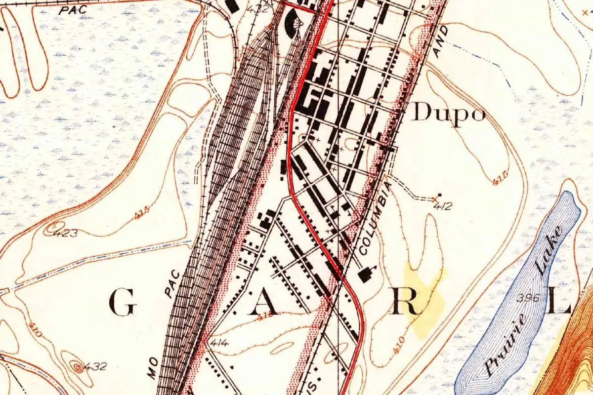
The railroad stayed at the center of things. On the Geological Survey’s map of 1934 at the top of this page, the yard tracks labeled “Mo Pac” spread in a wide fan beside the town. The 1939 guide adds that oil was found near Dupo in 1928, “wells were sunk in front lawns,” and the boom faded when the field turned out to be small. By then, the guide says, the railroad yards employed most of the town’s workers.
Prairie du Pont today
The old name hasn’t disappeared. The village history says the area still called Prairie du Pont lies between the railroad tracks and the canal bridge, and it’s where you’ll find the Boismenue-Martin house, which the village calls “the oldest know[n] house in Illinois.” That’s the village’s claim, and we didn’t check it against another source.
Quick answers
What does Dupo stand for?
It’s a shortening of Prairie du Pont, the name of the old French settlement south of Cahokia (WPA guide, 1939; Village of Dupo).
Who came up with the name Dupo?
Louis Dyroff, according to the village’s history, which says he shortened Prairie du Pont “when the railroad wanted a shorter name.”
What does Prairie du Pont mean?
The 1939 Illinois guide translates it “meadow of the bridge,” and the village history “prairie across the bridge.” Both say the name came from a small bridge the people of Cahokia built over a creek.
Key dates
- 1754Around this year the Mission of St. Sulpice builds a water mill on Prairie du Pont creek, the first in St. Clair County.
- 1760The French village of Prairie du Pont is founded about a mile (1.6 km) south of Cahokia.
- 1903The St. Louis Iron Mountain Railroad buys the property of the St. Louis Valley Railroad.
- 1905The town of Dupo is laid out.
- 1907September: Dupo is incorporated.
- 1928Oil is found near the outskirts of town, and a short boom follows.
Getting there
Open Dupo in Google Maps
Opens in a new tab. The pin is the center of Dupo in the USGS place-name record.
The closest airports, Amtrak stations and intercity bus stops, measured in a straight line from the center of Dupo.
Airports
- St Louis Lambert International (STL) St. Louis 18 mi 29 km
- Scott AFB/Midamerica St Louis (BLV) Belleville 20 mi 33 km
Amtrak trains
- St. Louis station (STL) 7 mi 12 km
- Kirkwood station (KWD) 12 mi 19 km
Intercity buses
- Executive Transportation Amtrak Connecting Service · St. Louis 7 mi 12 km
- FlixBus St Louis Bus Station 8 mi 12 km
- OurBus Richmond Heights, MO (Richmond Heights Metrolink station bus stop loop) 11 mi 18 km
Distances are as the crow flies, not by road. We don't list schedules or fares because they change; check with the airline, Amtrak or the bus company before you go. Official data (FAA commercial service airports (2025), FAA airport locations, Amtrak stations and Intercity Bus Atlas) from the FAA and the U.S. Bureau of Transportation Statistics, checked Nov 6, 2026.
Sponsored
Staying in Dupo?
Compare hotels in Dupo, Illinois, on Expedia.
See hotels in DupoWe may earn a commission if you buy through this link. It never changes what we write. Read our affiliate disclosure
Historical Sources & References
- Federal Writers’ Project, Illinois: A Descriptive and Historical Guide (1939), p. 494. Dupo’s name “contracted from Prairie du Pont (Fr., meadow of the bridge),” the Cahokians’ bridge, the oil boom of 1928 and the railroad yards.
- D. S. Raker and J. B. Spasovich, “History of Dupo” (Village of Dupo). The log bridge over Cahokia Creek, the railroads of 1903 to 1910, the town laid out in 1905 and incorporated in 1907, and Louis Dyroff’s shortening of the name.
- History of St. Clair County, Illinois (Brink, McDonough & Co., 1881), p. 47. Prairie du Pont after Cahokia, the St. Sulpice mill of about 1754, the founding in 1760, fourteen families in 1765 and the distance of one mile (1.6 km) from Cahokia.
- GNIS feature 426318 (U.S. Geological Survey). Dupo’s record in the Geological Survey’s names database, with its county and coordinates.
Spot something wrong, or know more? Tell us here. You can also email us or use our contact page. Corrections are noted here with their date, never made silently.