Garrett, Indiana: A B&O Shop Town Named for Its President
The town of Garrett, Indiana, was so tied to its railroad that DeKalb County drew a whole new township around it in 1876 so it wouldn’t sit in two. The railroad was the Baltimore & Ohio, and the town carries the name of its president, John W. Garrett.
The B&O’s town
The History of DeKalb County, Indiana, published in 1885, doesn’t leave much room for doubt: “The town of Garrett, named in honor of the lately deceased John W. Garrett, President of the Baltimore & Ohio Railroad Company, is indebted to that road for its very existence.” Henry Gannett’s 1905 bulletin for the Geological Survey agrees and adds that two other places carry the same man’s name, Garrett County in Maryland and the borough of Garrett in Somerset County, Pennsylvania.
The line came out of Garrett’s own plan. The county history says he wanted a company called the Baltimore, Pittsburg & Chicago to build a road from Pittsburgh to Chicago as part of the B&O system. Two routes were surveyed, and the one through DeKalb County, “being the most direct,” was picked in February 1872. All the county had to give was a 66-foot (20 m) right of way. The panic of 1873 and other troubles held up the work, and the first train didn’t run through the county until November 1, 1875.
Lots, a roundhouse and a prize baby
The town was laid out before the trains came. According to the county history, the railroad set aside 50 acres (20 ha) for its own use, and B. D. Thomas and a group of Ohio men bought several hundred more and sold building lots. The first went on sale in April 1875, and within a year 150 buildings were up.
The railroad’s buildings were the reason for all of it. The 1885 book describes a roundhouse, “a semi-circle of masonry 265 feet in diameter,” about 81 m, with stalls for 32 locomotives, and a brick, stone and iron machine shop 265 by 100 feet (81 by 30 m). Together they had room for a thousand workers, and Garrett was home to “many train men, conductors, engineers and other employes.” It sat four miles (6.4 km) west and one mile (1.6 km) south of Auburn, with about 1,200 people.
The new town offered a prize to the first child born there. You might guess how that went: two sets of parents claimed it, and “each child was duly honored,” according to the 1885 book.
A township for one town
Then there was the township problem. Garrett was founded right on the line between Richland and Butler townships. “To avoid having the town on two townships,” the history explains, the Board of Commissioners formed a new one at its June term in 1876 and called it Keyser Township. The roundhouse, it notes, stood “on the old township line.”
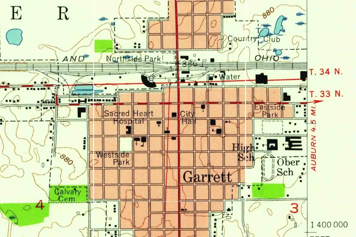
You can still see that seam on the Geological Survey’s 1957 map. A red township boundary, marked T. 34 N. and T. 33 N., runs just south of the black semicircle of the roundhouse beside the tracks. In the 1876 order that created Keyser, township 34 north is Richland and township 33 north is Butler.
Quick answers
Who was Garrett, Indiana, named after?
John W. Garrett, president of the Baltimore & Ohio Railroad, the line that built the town (History of DeKalb County, 1885; Gannett, 1905).
Why was Keyser Township created?
Because Garrett was founded on the line between Richland and Butler townships. In June 1876 the county commissioners made a new township, Keyser, so the town would be in just one.
How big was the Garrett roundhouse?
The 1885 county history gives it as a semicircle of masonry 265 feet (81 m) across, with stalls for 32 locomotives.
Key dates
- 1872February: the Baltimore & Ohio picks the route through DeKalb County for its line to Chicago.
- 1873A financial panic, among other causes, holds up construction.
- 1875April: the first town lots in Garrett are sold.
- 1875November 1: the first train runs through DeKalb County on the new line.
- 1876June: the county commissioners create Keyser Township so that Garrett sits in a single township.
Getting there
Open Garrett in Google Maps
Opens in a new tab. The pin is the center of Garrett in the USGS place-name record.
The closest airports, Amtrak stations and intercity bus stops, measured in a straight line from the center of Garrett.
Airports
- Fort Wayne International (FWA) 26 mi 42 km
- Kalamazoo/Battle Creek International (AZO) 65 mi 104 km
- Detroit Metro Wayne County (DTW) 109 mi 176 km
Amtrak trains
- Waterloo station (WTI) 8 mi 13 km
- Bryan station (BYN) 32 mi 51 km
Intercity buses
- Barons Bus Lines Fort Wayne 19 mi 31 km
- Greyhound Ft Wayne Citilink Central Station 19 mi 31 km
- GoBus Van Wert (E), OHIO 43 mi 69 km
Distances are as the crow flies, not by road. We don't list schedules or fares because they change; check with the airline, Amtrak or the bus company before you go. Official data (FAA commercial service airports (2025), FAA airport locations, Amtrak stations and Intercity Bus Atlas) from the FAA and the U.S. Bureau of Transportation Statistics, checked Nov 6, 2026.
Sponsored
Staying in Garrett?
Compare hotels in Garrett, Indiana, on Expedia.
See hotels in GarrettWe may earn a commission if you buy through this link. It never changes what we write. Read our affiliate disclosure
Historical Sources & References
- History of DeKalb County, Indiana (Inter-State Publishing Co., 1885). The B&O’s route through the county, adopted in February 1872, and the first train of November 1, 1875 (p. 459); Keyser Township, formed in June 1876 to keep Garrett in one township (pp. 673-674); the town “named in honor of” John W. Garrett, the roundhouse, the machine shop, the first lots of April 1875 and the prize for the first baby (pp. 675-676).
- Henry Gannett, The Origin of Certain Place Names in the United States, 2nd ed. (1905), p. 135. Garrett in DeKalb County, Garrett County, Maryland, and Garrett, Pennsylvania, all named for John W. Garrett.
- GNIS feature 434969 (U.S. Geological Survey). The USGS gazetteer’s line for Garrett in DeKalb County, with the point we use for the map.
Spot something wrong, or know more? Tell us here. You can also email us or use our contact page. Corrections are noted here with their date, never made silently.