Hot Springs, Arkansas: The Springs That Named a City
Hot Springs is named for its thermal springs. Explorers sent by Thomas Jefferson studied them in 1804, and the National Park Service says the country then heard of the 'hot springs of the Washitas.' Congress reserved the springs in 1832, and the town that grew beside them was incorporated in 1851.
Hot Springs, Arkansas, has the plainest of names: the town grew up around thermal springs that Congress set aside in 1832, 40 years before Yellowstone. The springs were known by that name well ahead of any town, and the federal government had a claim on them before the town had a charter.
Why is it called Hot Springs?
Because of the water, and that’s about as far back as the name goes. The National Park Service says President Thomas Jefferson sent George Hunter and William Dunbar to explore the southern part of the Louisiana Purchase, and that after their 1804 trip “Jefferson and the nation learned about the ‘hot springs of the Washitas.’” The Encyclopedia of Arkansas says the expedition traveled up the Ouachita River and spent four weeks studying the springs, though it never found where the water came from.
People came for the water and stayed. The Park Service puts the first permanent settlers there in 1807; the Encyclopedia of Arkansas names John Perciful, in 1809, as probably the first white settler to stay, and that by 1825 something like a hotel had opened. The encyclopedia also deals with a story you may hear, that the springs were a neutral ground where warring tribes bathed in peace. Those legends, it says, are “no doubt later embellishments” dreamed up for the tourist trade.
The springs Congress set aside
The Arkansas territorial legislature asked in 1820 for the springs and the mountains around them to be made a federal reservation, the Park Service says. Andrew Jackson signed the act on April 20, 1832, reserving “…four sections of land including said (hot) springs, reserved for the future disposal of the United States.” That makes it the oldest of today’s national park units, the Park Service says, older than Yellowstone by 40 years.
The town took shape beside the reservation. According to the Encyclopedia of Arkansas, its incorporation came on January 10, 1851, when it had two rows of hotels and the bathhouses; a rail line and the Arlington Hotel both arrived in 1875. The Park Service calls the result the “Great American Spa.” Not everyone could pay. By 1877 more than 400 people were camped on the west slope of Hot Springs Mountain in a squatters’ settlement called Ral City, short for neuralgia, soaking in pools they had dug themselves. Removing it was one of Superintendent B. F. Kelley’s first jobs, the Park Service says, though many of them came back.
The county that lost its spring
The name went on a county before the town was incorporated. The Encyclopedia of Arkansas says Hot Spring County was cut from Clark County in 1829, on November 2, and that Hot Springs served as its seat until Rockport took over in 1846. In 1873 residents of Hot Springs, tired of the long trip to Rockport, got the legislature to split the county, and Garland County was created that April. “Ironically,” the encyclopedia says, “the spring for which Hot Spring County is named is no longer within the county limits.”
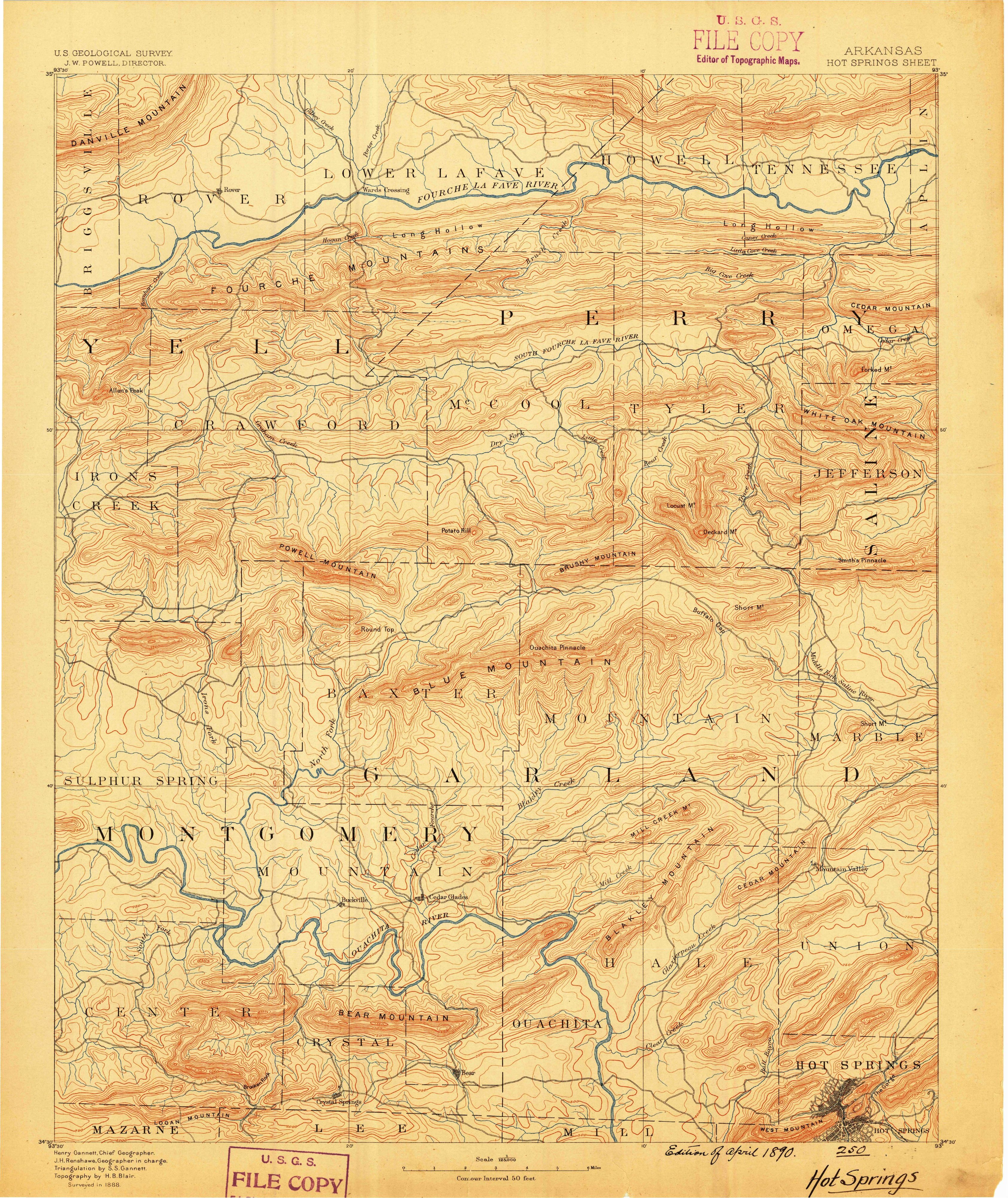
Henry Gannett, listed as chief geographer on the 1890 sheet shown above, noticed the same thing 15 years later. His Origin of Certain Place Names in the United States gave the county one line: “so named for the famous springs formerly within its limits.” He listed it as Hot Springs, with an s, but the county’s name is Hot Spring.
Hot Springs National Park, the city
On March 4, 1921, the reservation was made the 18th national park, as Hot Springs National Park. The Park Service says “the townspeople decided to call their city Hot Springs National Park as well.” In the federal names database the city is plain Hot Springs, and its entry notes a 1943 decision of the Board on Geographic Names. The Park Service also calls it the Spa City.
Other towns with the same plain name have handled it differently. Hot Springs, South Dakota, got its name from warm springs too, though one 1899 history would rather it had chosen Minnekahta, the Sioux name. Truth or Consequences, New Mexico, was Hot Springs from 1916 until 1950, when its voters traded the name for a radio quiz show’s. Closer to home, the people camped at a healing spring in Eureka Springs picked Eureka, Greek for “I have found it,” on July 4, 1879.
Hot Springs on the 1890 map
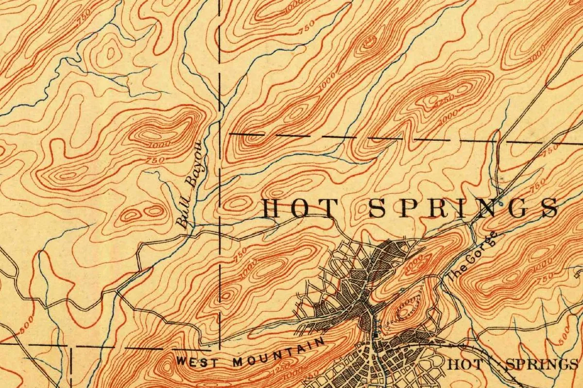
The map above was cropped from the Geological Survey’s Hot Springs sheet, Arkansas, at 1:125,000, with a contour interval of 50 feet (15 m). Its margin names J. W. Powell, director; Henry Gannett, chief geographer; J. H. Renshawe, geographer in charge; S. S. Gannett for the triangulation; and H. B. Blair for the topography, “Surveyed in 1888.” “Edition of April 1890” is written in by hand, and the sheet carries Survey file-copy stamps.
On the full sheet, the town is squeezed against the lower margin. In the crop, HOT SPRINGS is printed in large spaced capitals across the ridges, a style the sheet also uses for names like UNION and HALE, and a second HOT SPRINGS label sits beside the dense street grid in the valley below. West Mountain is on one side of town and The Gorge on the other, with Bull Bayou to the west and contours climbing from 500 to 1250 feet (150 to 380 m).
Quick answers
Why is Hot Springs, Arkansas, called that?
For its thermal springs, which Jefferson’s explorers studied in 1804 and Congress reserved in 1832.
Is Hot Springs the oldest national park?
The Park Service says Hot Springs Reservation, set aside in 1832, makes it the oldest unit among today’s national parks, 40 years ahead of Yellowstone.
Why isn’t Hot Springs in Hot Spring County?
Because Garland County was split off in 1873, taking the city and its springs with it.
Key dates
- 1804The Hunter-Dunbar expedition, sent by Thomas Jefferson, spends about four weeks studying the springs.
- 1807The first permanent settlers arrive, according to the National Park Service.
- 1820The Arkansas territorial legislature asks for the springs to be made a federal reservation.
- 1829Hot Spring County is formed on November 2, with Hot Springs as its seat.
- 1832On April 20, Andrew Jackson signs the act reserving four sections of land around the springs.
- 1851The town of Hot Springs is incorporated on January 10.
- 1873Garland County is carved out of Hot Spring County, taking the city and its springs.
- 1875The Arlington Hotel is finished and a rail line reaches the city.
- 1890The Geological Survey issues its Hot Springs sheet, surveyed in 1888.
- 1921Hot Springs Reservation becomes a national park on March 4, and the townspeople name their city Hot Springs National Park.
Things to do in Hot Springs, Arkansas
Fordyce Bathhouse
A bathhouse that ran from 1915 to 1962 and has been the park's visitor center since 1989. You can tour three floors and the basement, including the Music Room, a bowling alley no other bathhouse had, and the Fordyce Spring.
Grand Promenade
A brick National Recreation Trail behind Bathhouse Row, begun in the 1930s, where the Oertel, Peak and Tufa Terrace trails branch off into the mountains.
Hot Water Cascade
The largest spring you can see in the park, at Arlington Lawn, where thermal water runs down a cliff into two pools and has cooled enough to touch.
Lamar Bathhouse
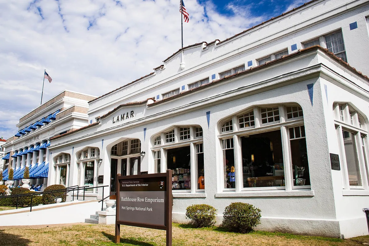
A Bathhouse Row building that opened in 1923, named for Lucius Q. C. Lamar, who was secretary of the interior when the first wooden Lamar went up. It now holds park offices and the Bathhouse Row Emporium store.
Getting there
Open Hot Springs in Google Maps
Opens in a new tab. The pin is the center of Hot Springs in the USGS place-name record.
The closest airports, Amtrak stations and intercity bus stops, measured in a straight line from the center of Hot Springs.
Airports
- Bill and Hillary Clinton Ntl/Adams Field (LIT) Little Rock 50 mi 80 km
- Texarkana Regional-Webb Field (TXK) 90 mi 145 km
Amtrak trains
- Malvern station (MVN) 17 mi 27 km
- Arkadelphia station (ARK) 27 mi 43 km
Intercity buses
- Jefferson Lines Russellville 17 mi 28 km
- Greyhound Bryant-Little Rock Gassy's 33 mi 53 km
Distances are as the crow flies, not by road. We don't list schedules or fares because they change; check with the airline, Amtrak or the bus company before you go. Official data (FAA commercial service airports (2025), FAA airport locations, Amtrak stations and Intercity Bus Atlas) from the FAA and the U.S. Bureau of Transportation Statistics, checked Nov 18, 2026.
Sponsored
Staying in Hot Springs?
Compare hotels in Hot Springs, Arkansas, on Expedia.
See hotels in Hot SpringsWe may earn a commission if you buy through this link. It never changes what we write. Read our affiliate disclosure
Historical Sources & References
- National Park Service, “History & Culture”. The 1804 expedition, the settlers of 1807, the request of 1820, the act of April 20, 1832, and the national park and the city’s new name in 1921.
- National Park Service, “Uncovering Ral City”. The “hot springs of the Washitas,” Ral City and the Spa City.
- Encyclopedia of Arkansas, “Hot Springs”. The four-week study of 1804, John Perciful, the neutral-ground legend, the incorporation of January 10, 1851, and the Arlington and the railroad in 1875.
- Encyclopedia of Arkansas, “Hot Spring County”. The county of 1829, the move to Rockport in 1846 and the division of 1873.
- Henry Gannett, The Origin of Certain Place Names in the United States (1905), p. 161. The county “so named for the famous springs formerly within its limits.” Checked against the page image.
- National Park Service pages on the Lamar Bathhouse, Fordyce Bathhouse, Grand Promenade and Hot Water Cascade. The details in the things-to-do list.
- U.S. Geological Survey, GNIS feature 77237. Hot Springs in Garland County, with a board decision dated 1943.
- Hot Springs sheet, surveyed 1888, edition of April 1890. The sheet the map at the top was cropped from.
Sponsored
Put this 1890 map on your wall
The Geological Survey's April 1890 Hot Springs sheet, surveyed in 1888, with the town in its valley between West Mountain and The Gorge, is in the public domain. Download the full-size scan for free, then have it printed on canvas with CanvasOnTheCheap.
Print a map on canvasDownload the full-size mapWe may earn a commission if you buy through this link. It never changes what we write. Read our affiliate disclosure
Spot something wrong, or know more? Tell us here. You can also email us or use our contact page. Corrections are noted here with their date, never made silently.