New Castle, Delaware History: Four Names Before New Castle
The English renamed New Amstel after capturing it in 1664; the earliest use of the new name C. A. Weslager found is a pass of April 1665. No record says whom it honors. Henry Gannett said such places were generally named for the English town or the Duke of Newcastle; Weslager pointed to William Cavendish, made duke in March 1665.
New Castle, Delaware, went from Fort Casimir to Fort Trinity to New Amstel to New Castle in about 13 years, as Dutch, Swedes and English took turns. The last name is the one that stuck, and it has now lasted more than 350 years. What nobody wrote down at the time is which castle, or which duke, it was meant to recall.
A sandy point with a beaver name
Before the forts, the spot had names of its own. The Geological Survey’s Delaware Place Names, published in 1966, lists Santhoeck, which it translates as “sand-point,” and Tamakonck, “possibly meaning ‘place of the beaver.’” A state historical marker put up in 1932 gives the beaver meaning without the “possibly.”
Historian C. A. Weslager, writing in the journal Names in 1976, says the Swedish engineer Peter Lindeström wrote both on one of his maps in 1654: “Tamakonck, the Sandhoeck, now called Trinity Fort.” The National Park Service calls the place Sandhoek, “Sand Hook or Sand Point.” Weslager adds that the sandbank itself has long since eroded away.
Fort Casimir and Fort Trinity
In 1651, the Park Service says, the Dutch built Fort Casimir at the sand hook on the orders of Peter Stuyvesant. Weslager explains the name: “Casimir was the family name of Count Ernest of Nassau, a distinguished stadtholder and a soldier from Stuyvesant’s home province of Friesland.” The settlement that grew up around the fort, about 22 houses, went by the fort’s name.
Three years later, the Swedes sailed in and took it. Lindeström, who was aboard, wrote that the fort was captured “on Trinity Sunday 1654,” and so “this fortress was called Fort Trinity [Trefaldigheet] by the Swedes.” The quotation, as Weslager gives it, carries the date, May 21, in brackets. The Dutch took it back in 1655 and restored the old name.
New Amstel, a town owned by a city
The third name came with a sale. Weslager says that on August 16, 1656, the City of Amsterdam bought the Fort Casimir community from the Dutch West India Company, and its commissioners renamed it Nieuwer-Amstel, or New Amstel, after “a village and country district adjoining the City of Amsterdam.” In a footnote, Weslager adds that an early writer tied the name instead to a stream of water that flowed through Amsterdam. He calls it “a unique situation,” a European city that actually owned a colony in the New World.
The sources don’t agree on the year. The state’s Court House Museum timeline says 1656, the Park Service and the 1966 place-names book say 1657, and the 1932 marker says 1655.
Dellawarr Fort, then New Castle
In 1664, English forces under Sir Robert Carr took New Amstel for James, Duke of York. The Park Service says the fighting lasted less than an hour, with three Dutch soldiers killed and ten wounded, and that Carr claimed lands as far south as present-day Lewes. It was the same campaign that turned Fort Orange into Albany, after the duke’s Scottish title.
New Castle wasn’t the first English name, though. Weslager found that Carr dated a letter of October 13, 1664, from “Dellawarr Fort,” which he calls “the first English name applied to New Amstel.” The earliest use of “New Castle” he knew of is a pass of April 22, 1665, in which Colonel Richard Nicolls, the leader of the duke’s expedition, writing from New York, let a trader go “to New Castle in Delaware Bay.”
Weslager thinks Nicolls chose the name. “It seems likely that Colonel Nicolls was responsible,” he wrote, since Nicolls was the ranking officer and, in an undated letter to the duke, said he had named New York, Yorkshire and Albania for the duke’s titles. The state’s timeline and the 1966 place-names book say only that the English captured the town in 1664 and it received its present name.
Which castle?
If you’re looking for a document that settles it, the record goes quiet here. “Why Nicolls applied the name New Castle to the former Dutch town is not explained in the documents,” Weslager wrote, “but circumstantial evidence provides a logical answer.” On March 16, 1665, William Cavendish, who had stayed loyal to the Crown through the English Civil Wars, was created Duke of New Castle. That was 38 days before the pass. Weslager argued there was time, “with favorable winds,” for the news to reach New York.
Henry Gannett covered the name more broadly in 1905. His entry for Newcastle, which takes in the Delaware county and twenty towns, says they were “generally so called from the town in England or for the Duke of Newcastle.” Weslager himself didn’t claim to know which of America’s other New Castles came from Delaware and which from the English towns. One that points to the English coal port is Newcastle, Wyoming, said to be named for the mine boss’s hometown, Newcastle upon Tyne.
Capital of Delaware until 1777
Whatever the name honored, the town became the seat of government. The Court House Museum timeline says William Penn arrived on October 27, 1682, the Lower Counties held their first separate assembly in 1704, and the courthouse was built in 1732. On June 15, 1776, New Castle became the first state capital of Delaware. It held the title until May 12, 1777, when the government moved to Dover.
The town also gave the state its odd round border. The New Castle Historical Society says the arc of Delaware’s northern boundary was first surveyed in 1701 on a circle with a radius of 12 miles (19 km) centered on New Castle.
New Castle on the 1904 map
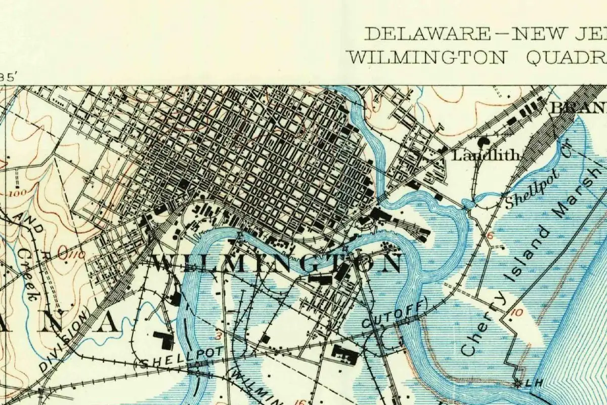
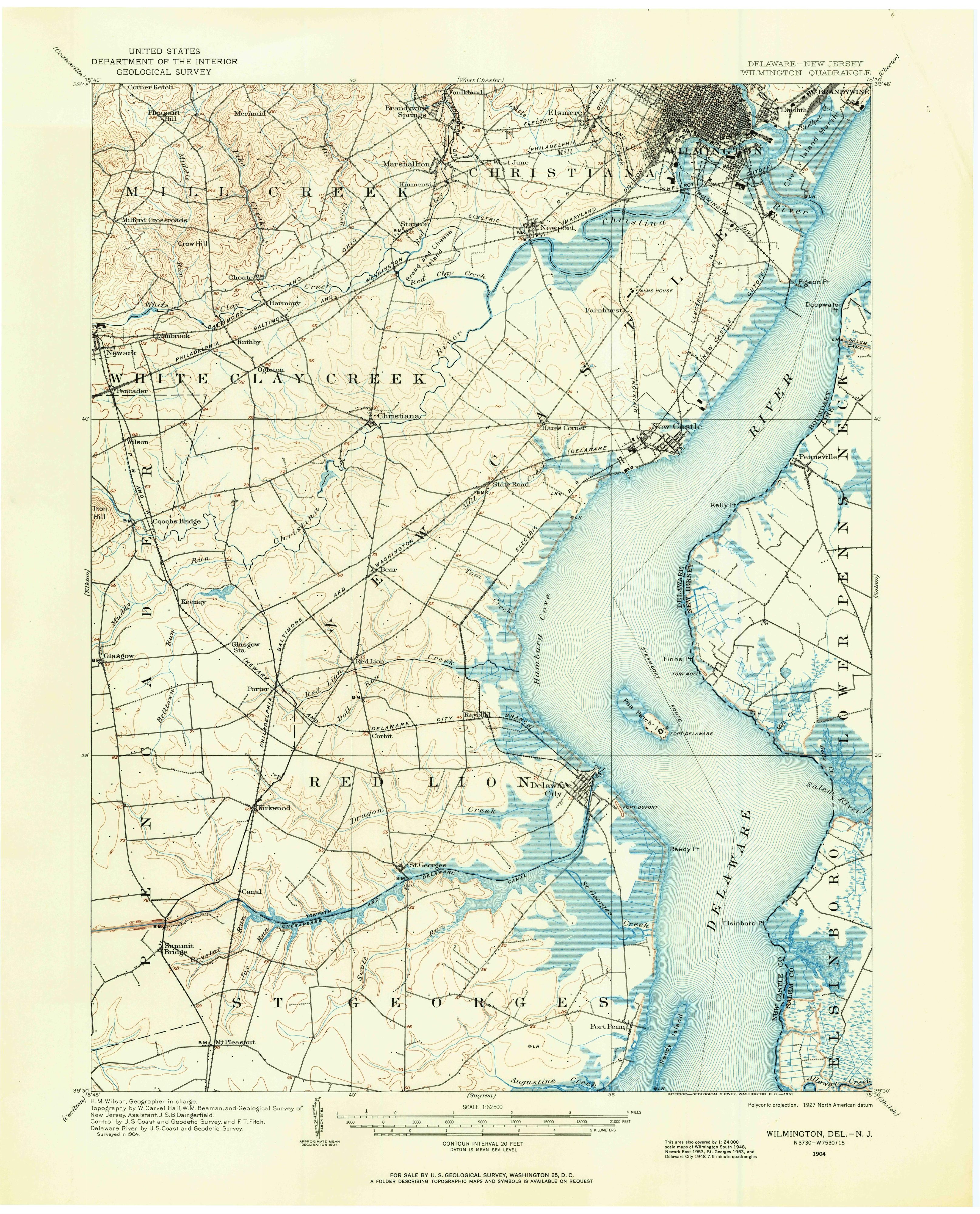
The map at the top of this page comes from the Geological Survey’s Wilmington quadrangle, surveyed in 1904. This copy was printed in 1961, as the printer’s line in the bottom margin says. On the full sheet, New Castle sits on the west shore of the Delaware River, right of center and about a third of the way down, with Wilmington at the top right.
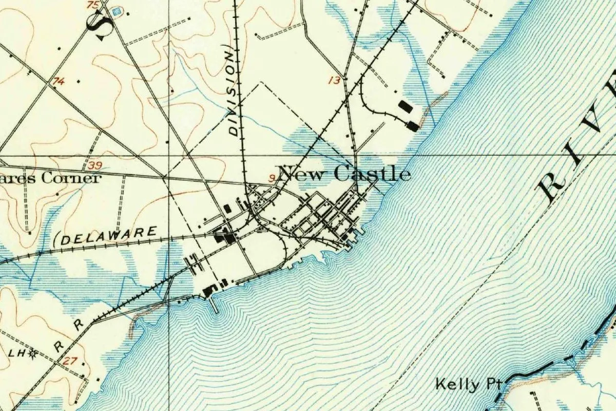
In the detail, you can see the town’s small grid of streets at the water’s edge, with piers along the shore and several railroad lines meeting just west of it. The big letters “RIVE” in the water belong to the river’s label, and Kelly Point is on the far shore. The contour interval on this sheet is 20 feet (6 m).
Quick answers
Who is New Castle, Delaware, named after?
No document says. Historian C. A. Weslager pointed, on circumstantial evidence, to William Cavendish, created Duke of New Castle in March 1665. Henry Gannett said places with the name were generally named for the English town or the Duke of Newcastle.
What was New Castle, Delaware, called before?
Fort Casimir under the Dutch from 1651, Fort Trinity under the Swedes from 1654, and New Amstel under the City of Amsterdam. Weslager says Sir Robert Carr’s first English name for it was “Dellawarr Fort.”
When did New Castle get its name?
After the English captured it in 1664. The earliest use Weslager found is a pass dated April 22, 1665.
Was New Castle the capital of Delaware?
Yes. The state’s Court House Museum says New Castle became the first state capital on June 15, 1776, and the government moved to Dover on May 12, 1777.
Key dates
- 1651The Dutch build Fort Casimir at the Sand Hook, on Peter Stuyvesant's order.
- 1654Swedish forces take the fort on Trinity Sunday and call it Fort Trinity.
- 1656The City of Amsterdam buys the community on August 16, according to C. A. Weslager, and renames it New Amstel.
- 1664English forces under Sir Robert Carr capture the town for James, Duke of York; Carr writes from "Dellawarr Fort" on October 13.
- 1665On April 22, a pass signed by Richard Nicolls uses the name New Castle, the first documentary mention Weslager knew of.
- 1732The New Castle Court House is built.
- 1776On June 15, New Castle becomes Delaware's first state capital.
- 1777On May 12, the state government moves to Dover.
Things to do in New Castle, Delaware
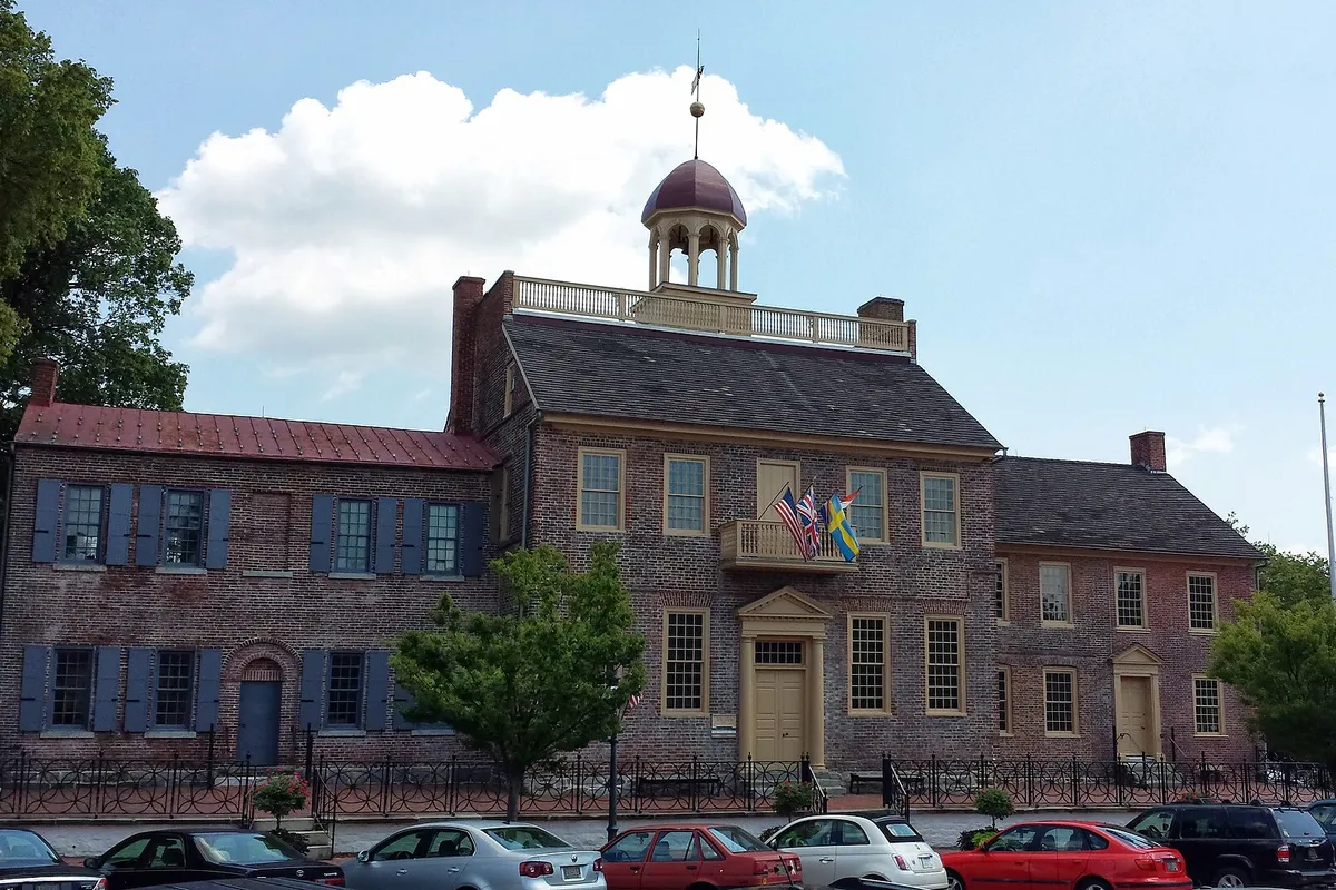
New Castle Court House Museum
The courthouse built in 1732, which the state calls Delaware's first court and state capitol, now a museum run by the Delaware Division of Historical and Cultural Affairs, with an exhibit on the Dutch, Swedish and English forts called Three Forts, One Community.
Amstel House
A brick house built by physician John Finney after he bought the lot in 1738, on property first owned by Jan Roeloff deHaes, one of the settlers of Fort Casimir. George Washington came here for a wedding in April 1784, according to the New Castle Historical Society.
Dutch House
A small house the New Castle Historical Society dates to between 1690 and 1710 and counts among the oldest in Delaware. Despite its long-standing name, the society says it isn't Dutch: its construction follows English building traditions with some Netherlandish touches.
The Arsenal
A federal storehouse finished between 1809 and 1811 to supply the river defenses around New Castle before and during the War of 1812. It's now home to the New Castle Historical Society.
New Castle Historic District
A district of more than 600 historic structures, by the historical society's count, in the town that gave Delaware its curved northern border: the arc was first surveyed in 1701 on a circle with a 12-mile (19 km) radius from New Castle.
Getting there
Open New Castle in Google Maps
Opens in a new tab. The pin is the center of New Castle in the USGS place-name record.
The closest airports, Amtrak stations and intercity bus stops, measured in a straight line from the center of New Castle.
Airports
- New Castle (ILG) Wilmington 2 mi 4 km
- Philadelphia International (PHL) 23 mi 36 km
Amtrak trains
- Wilmington station (WIL) 5 mi 8 km
- Newark station (NRK) 10 mi 16 km
Intercity buses
- OurBus Wilmington - Christiana, DE (Christiana Mall - Public bus stop opposite Target - Mall Parking Lot Section D3. One-day customer parking is allowed.) 5 mi 7 km
- Greyhound Wilmington E Front St 5 mi 8 km
- FlixBus Delaware Rest Stop N 7 mi 11 km
Distances are as the crow flies, not by road. We don't list schedules or fares because they change; check with the airline, Amtrak or the bus company before you go. Official data (FAA commercial service airports (2025), FAA airport locations, Amtrak stations and Intercity Bus Atlas) from the FAA and the U.S. Bureau of Transportation Statistics, checked Nov 18, 2026.
Sponsored
Staying in New Castle?
Compare hotels in New Castle, Delaware, on Expedia.
See hotels in New CastleWe may earn a commission if you buy through this link. It never changes what we write. Read our affiliate disclosure
Historical Sources & References
- National Park Service, “Fort Casimir: The Beginnings of New Castle”. Fort Casimir at the Sand Hook in 1651, the Swedish capture, New Amstel in 1657, and Carr’s capture of 1664.
- C. A. Weslager, “New Castle, Delaware—and its Former Names,” Names (1976). Count Ernest of Nassau, Trinity Sunday 1654, the sale of August 16, 1656, “Dellawarr Fort,” the pass of April 22, 1665, Nicolls, and the case for William Cavendish.
- Delaware Division of Historical and Cultural Affairs, New Castle Court House Museum history. The timeline from 1651 to 1777, including New Amstel in 1656 and the first state capital.
- Delaware Place Names (USGS Bulletin 1245, 1966), p. 80. The variant names, Santhoeck as “sand-point,” Tamakonck “possibly meaning ‘place of the beaver,’” and the English capture of 1664.
- Henry Gannett, The Origin of Certain Place Names in the United States (1905), p. 223. “Generally so called from the town in England or for the Duke of Newcastle.”
- Delaware Public Archives, marker NC-30. Tamakonck, “place of the beaver,” and the forts’ names and dates.
- New Castle Historical Society. The circle of 1701, the Amstel House, the Dutch House and the Arsenal.
- National Park Service, First State National Historical Park FAQ. The Court House as the first capital.
- New Castle’s entry in GNIS, feature 214379 (U.S. Geological Survey). The town’s listing as a populated place in New Castle County, with its coordinates.
- U.S. Geological Survey, Wilmington quadrangle (surveyed 1904, printed 1961). The 1:62,500 sheet the map at the top was cropped from.
Sponsored
Put this 1904 map on your wall
The Geological Survey's Wilmington quadrangle, surveyed in 1904 (this copy was printed in 1961), with New Castle on the Delaware River below Wilmington, is in the public domain. Download the full-size scan for free, then have it printed on canvas with CanvasOnTheCheap.
Print a map on canvasDownload the full-size mapWe may earn a commission if you buy through this link. It never changes what we write. Read our affiliate disclosure
Spot something wrong, or know more? Tell us here. You can also email us or use our contact page. Corrections are noted here with their date, never made silently.