Rockport, Massachusetts: Rocky Shores and Granite Quarries
Rockport got its name when it was incorporated apart from Gloucester on February 27, 1840. John Hayward's 1847 gazetteer says the town 'derives its name from the character of its shores and surface'; Elias Nason wrote in 1874 that it was named for 'its most striking local feature,' and Henry Gannett credited its granite quarries near the sea.
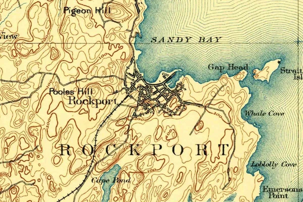
When Rockport, Massachusetts, split from Gloucester in 1840, it took a name an 1847 gazetteer called appropriate and tied to the character of its shores. You can check its word against the map at the top of this page, where ROCKPORT runs across a coast of coves, points and hills.
Sandy Bay goes its own way
Before 1840 there was no Rockport. The head of Cape Ann was part of Gloucester, and its main village was Sandy Bay. A 2005 state report on the town’s historic landscapes dates the first permanent English settlement there to 1690.
John J. Babson, writing the history of Gloucester in 1860, says Sandy Bay grew faster than any other part of the old town, on the strength of shore fishing, farming and “the quarrying of stone.” Its people tried to break away in 1818, when the question went to town meeting, and again in 1827. Both times they couldn’t agree among themselves. When they finally did, Babson writes, the people of Gloucester Harbor didn’t stand in their way. “The act for the incorporation of Rockport passed the two legislative branches, and received the approval of the Governor on the same day,” Feb. 27, 1840. The first town meeting followed on March 9. The new town took in the Fifth Parish of Gloucester and part of the Third, around Pigeon Cove.
What the name describes
None of these writers says who picked the name. What they do say is what it describes. John Hayward’s Gazetteer of Massachusetts, published seven years after the split, put it this way:
“This was a part of the ancient town of Gloucester until its incorporation in 1840, when it received the appropriate name of Rockport.” (Hayward, p. 253)
Further down he adds that “the town derives its name from the character of its shores and surface,” though it has, he notes, “many large tracts of clear land.” He also points to the “inexhaustible quarries of excellent granite” at Pigeon Cove.
Elias Nason’s gazetteer of 1874 says Rockport “was named from its most striking local feature.” He doesn’t name the feature in that sentence, but a page earlier he describes the town’s surface as “remarkably broken and rocky, huge masses of sienite cropping out in every section,” and he says Rockport stone went into the post office and many other new buildings in Boston.
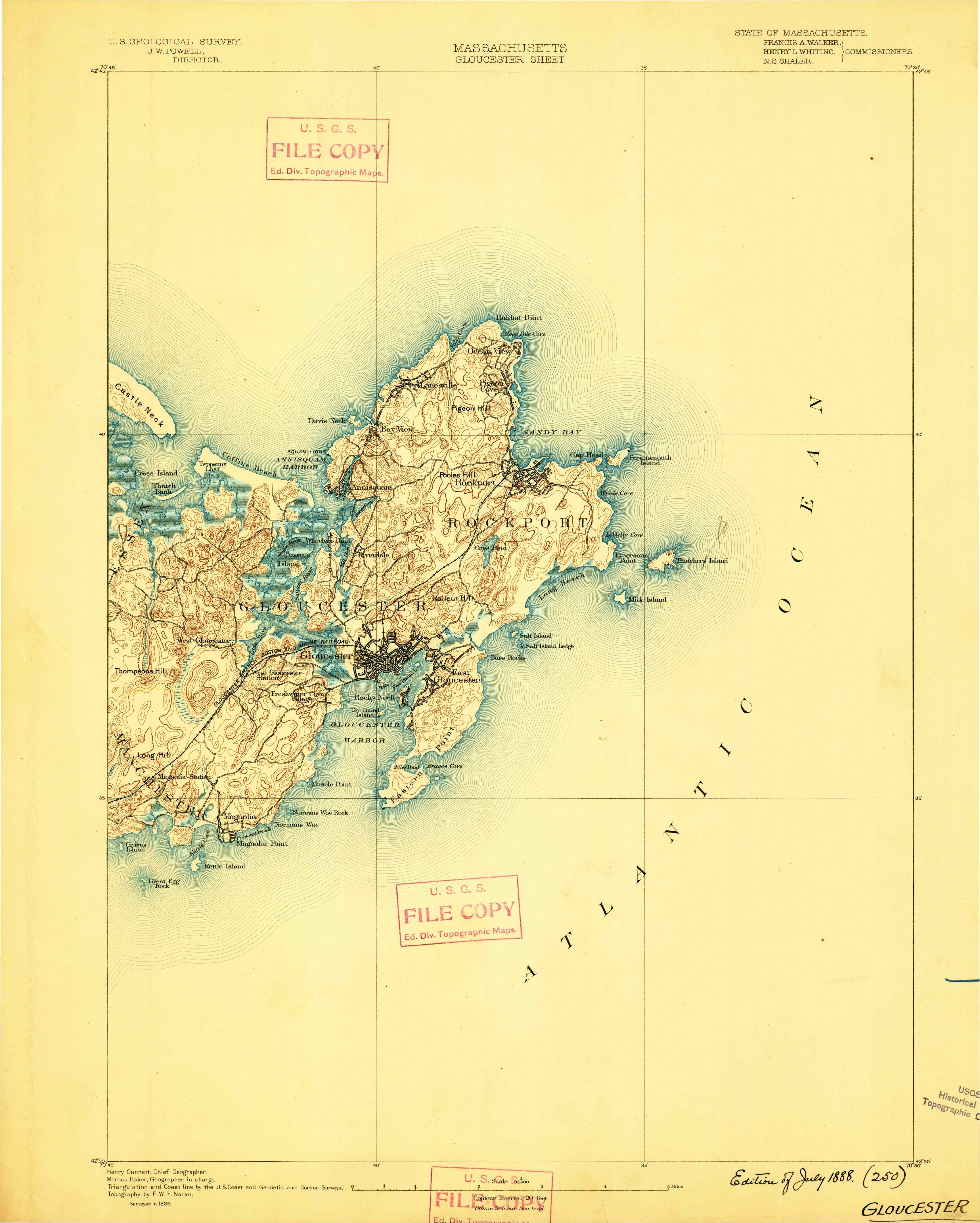
Henry Gannett, whose name is printed as chief geographer in the margin of the 1888 map at the top of this page, went straight to the quarries when he wrote the town up for the Geological Survey in 1905: “so named on account of the granite quarries near the sea.” Nason’s 1874 gazetteer goes town by town through Massachusetts, and of the three, only Gannett ties the name to the quarries rather than to the land itself.
A port built by hand
The “port” half is harder. None of these sources explains it. What they do show is that the town had to build its harbors. Babson says Sandy Bay’s fishermen could only work in small boats “on account of the want of a harbor, or even a place of refuge in case of a storm.” In 1743 a few residents got “liberty to build a wharf at the Whirlpool,” with room for a warehouse on Bearskin Neck, but it wasn’t until 1811 that the village built a breakwater on the Neck, and in 1819 a wharf opposite it. Babson calls the pair “an honorable testimonial of their efforts to supply the only convenience that Nature had denied them.” The quarrying and shipping of stone began in 1824, by Babson’s dates, and the federal government started a breakwater at Long Cove in 1836.
The state’s 2005 report says the same thing in fewer words: the town “had no natural harbors,” and “All harbors in town are man-made.” Hayward, in 1847, had already noted that “Artificial harbors have been constructed at both villages.”
Maine has a Rockport, too: the village of Goose River renamed itself Rockport and split from Camden in 1891. Granite made a name for other towns as well: Mount Airy, North Carolina, got the nickname “Granite City” from its quarry.
Rockport on the 1888 map
The map at the top comes from the Geological Survey’s Gloucester sheet, surveyed in 1886, with the State of Massachusetts and its commissioners named in the header, Henry Gannett as chief geographer, Marcus Baker as geographer in charge and topography by E. W. F. Natter. This scan is a Survey file copy with a handwritten note in the corner, “Edition of July 1888,” and no later printing. On the full sheet, Rockport fills the eastern tip of Cape Ann, with the Atlantic to the east and Gloucester to the southwest. In the crop you’ll see the village of Rockport at the head of a small harbor, “SANDY BAY” printed on the water above it, “ROCKPORT” spread in big letters across the town, Pooles Hill and Pigeon Hill, Gap Head, Whale Cove, Loblolly Cove and Emersons Point along the shore, and Cape Pond inland.
Quick answers
Why is it called Rockport?
John Hayward wrote in 1847 that the town “derives its name from the character of its shores and surface.” Elias Nason (1874) said it was named for “its most striking local feature,” and Henry Gannett (1905) credited “the granite quarries near the sea.”
When did Rockport separate from Gloucester?
On February 27, 1840, when the act incorporating the town passed the legislature and was approved by the governor the same day, according to John J. Babson’s 1860 history.
What was Rockport called before?
It was the Sandy Bay part of Gloucester: the village of Sandy Bay and the Fifth Parish, with part of the Third Parish around Pigeon Cove, Babson says.
Did Rockport have a natural harbor?
No. Babson writes that Sandy Bay lacked even “a place of refuge in case of a storm” until it built a breakwater in 1811, and a 2005 state report says all the town’s harbors are man-made.
Key dates
- 1690The first permanent English settlement is made in what is now Rockport, the state's 2005 report says.
- 1811Sandy Bay builds a breakwater on Bearskin Neck, adding a wharf in 1819, for want of a natural harbor.
- 1818A first attempt to set Sandy Bay off from Gloucester comes to nothing; a second fails in 1827.
- 1824Quarrying and shipping stone begins at the head of Cape Ann, by Babson's dates.
- 1840The act incorporating Rockport passes and is approved by the governor on February 27.
- 1847John Hayward's gazetteer says the town takes its name from "the character of its shores and surface."
- 1888The Geological Survey's Gloucester sheet, surveyed in 1886, shows Rockport on Sandy Bay.
- 1905Henry Gannett writes that Rockport was named for the granite quarries near the sea.
Things to do in Rockport, Massachusetts
Halibut Point State Park
A state park on what the state calls a granite edge between the Atlantic and the mainland, with trails, tide pools and rocky ledges, and the history of the Cape Ann granite industry and of World War II on the coast.
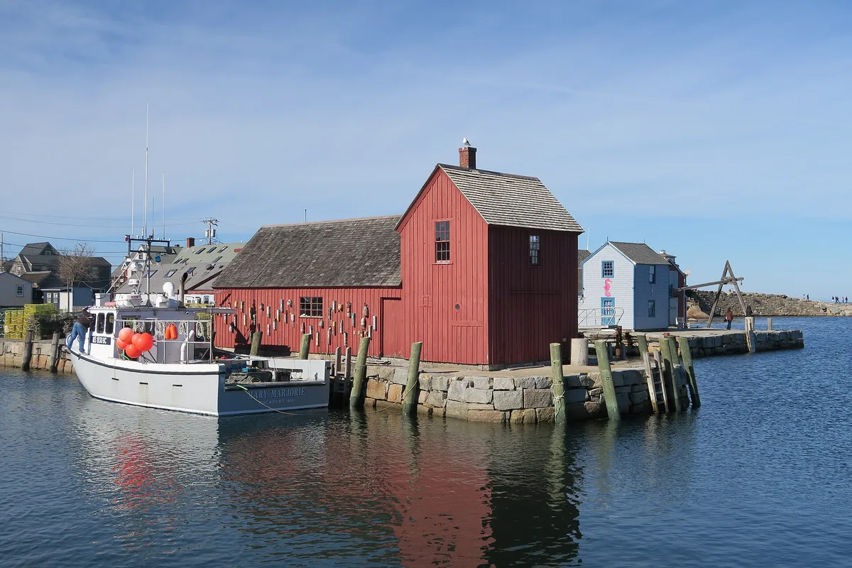
Motif No. 1
The little red fishing shack in the harbor that the town's points-of-interest page calls the most painted building in the world.
Rockport Art Association & Museum
An art association on Main Street whose collection spans more than a century of Cape Ann art, from founders such as Aldro T. Hibbard and Anthony Thieme to painters like Childe Hassam who worked on the cape.
Thacher and Straitsmouth Islands
Two islands off the coast, with the Cape Ann Light Station on Thacher Island, a National Historic Landmark, and Straitsmouth Island Light, on the National Register; the islands' association runs boat launches to Thacher.
Getting there
Open Rockport in Google Maps
Opens in a new tab. The pin is the center of Rockport in the USGS place-name record.
The closest airports, Amtrak stations and intercity bus stops, measured in a straight line from the center of Rockport.
Airports
- General Edward Lawrence Logan International (BOS) Boston 28 mi 45 km
- Portsmouth International at Pease (PSM) 31 mi 50 km
Amtrak trains
- Haverhill station (HHL) 25 mi 40 km
- Exeter station (EXR) 28 mi 46 km
Intercity buses
- CandJ Bus Lines Seabrook 21 mi 34 km
- Peter Pan (BZ) Peter Pan Bus Lines · Logan International Airport (Terminal E) 28 mi 46 km
- Peter Pan Bus Lines Logan International Airport (Terminal E) 28 mi 46 km
Distances are as the crow flies, not by road. We don't list schedules or fares because they change; check with the airline, Amtrak or the bus company before you go. Official data (FAA commercial service airports (2025), FAA airport locations, Amtrak stations and Intercity Bus Atlas) from the FAA and the U.S. Bureau of Transportation Statistics, checked Nov 18, 2026.
Sponsored
Staying in Rockport?
Compare hotels in Rockport, Massachusetts, on Expedia.
See hotels in RockportWe may earn a commission if you buy through this link. It never changes what we write. Read our affiliate disclosure
Historical Sources & References
- John Hayward, A Gazetteer of Massachusetts (1847), p. 253. “The appropriate name of Rockport,” the name from “the character of its shores and surface,” the Pigeon Cove granite and the artificial harbors. Checked against the page image.
- Elias Nason, A Gazetteer of the State of Massachusetts (1874), pp. 434-435. The “remarkably broken and rocky” surface, the quarries and the stone for Boston, and the name “from its most striking local feature.” Checked against the page image.
- Henry Gannett, The Origin of Certain Place Names in the United States (1905), p. 265. “So named on account of the granite quarries near the sea.”
- John J. Babson, History of the Town of Gloucester, Cape Ann, Including the Town of Rockport (1860), pp. 543-546. Sandy Bay’s growth, the want of a harbor, the breakwater of 1811 and the wharf of 1819, the stone business, the attempts of 1818 and 1827, the act of February 27, 1840, the first town meeting and the parishes the new town took in.
- Rockport Reconnaissance Report (2005). The settlement of 1690, “no natural harbors,” “All harbors in town are man-made,” and the incorporation of 1840.
- Halibut Point State Park; Town of Rockport, Points of Interest; Rockport Art Association & Museum; Thacher & Straitsmouth Islands Association. The details in the things-to-do list.
- U.S. Geological Survey, GNIS feature 616229. Where the national names database puts the town, in Essex County.
- Gloucester sheet, surveyed 1886, edition of July 1888. The sheet the map at the top was cropped from, with triangulation and coast line by the U.S. Coast and Geodetic and Borden surveys.
Sponsored
Put this 1888 map on your wall
The Geological Survey's 1888 Gloucester sheet, surveyed in 1886, with Rockport at the eastern tip of Cape Ann, is in the public domain. Download the full-size scan for free, then have it printed on canvas with CanvasOnTheCheap.
Print a map on canvasDownload the full-size mapWe may earn a commission if you buy through this link. It never changes what we write. Read our affiliate disclosure
Spot something wrong, or know more? Tell us here. You can also email us or use our contact page. Corrections are noted here with their date, never made silently.