Rock Hill, South Carolina: A Knoll on a Railroad Map
Rock Hill is named for a small, flinty knoll that the Charlotte and South Carolina Railroad ran into while it was being built. The South Carolina Encyclopedia says the name came from a notation on a construction supervisor's map, and the town began there in 1852 as a depot and watering station.
Rock Hill, South Carolina, got its name from a note on a railroad construction map, marking the spot where the line ran into a small, flinty knoll. The hill in the name was a construction supervisor’s working label for a bump in the railroad’s path.
A note on the supervisor’s map
The South Carolina Encyclopedia tells it in two sentences. Rock Hill “began in 1852 as a depot and watering station on the Charlotte and South Carolina Railroad,” Matthew A. Lockhart writes in its entry on the city, and “the name came from a notation on a construction supervisor’s map marking a spot where the road encountered a small, flinty knoll.”
The Advisory Council on Historic Preservation tells the same story in slightly different words. Its Preserve America profile of the city says the railroad’s direct route from Charlotte south to Columbia “made what engineers termed “rocky hill” on the company’s rail map into today’s community.”
So you get “flinty knoll” from one source and “rocky hill” from the other, but the same picture: the railroad’s builders, a map, and a stony rise they had to deal with. Neither source names the supervisor, and neither reproduces the map. What they agree on is that the name started as a working note.
The town Ebenezer didn’t want
The land wasn’t empty before the railroad builders showed up. The ACHP says the area, about 15 miles (24 km) south of Charlotte, North Carolina, was first home to the Catawba, and that white settlers were moving into what was called Indian Land as early as the 1730s. The railroad came more than a century later.
The railroad hadn’t planned to come this way at all. According to the encyclopedia, it meant to run the line through nearby Ebenezer, then the second-largest settlement in York District. Ebenezer’s people objected to “the smoke and noise a train would produce,” and the railroad had to build elsewhere.
That’s where Alexander Templeton Black comes in. He was a plantation owner who let the railroad cross his property, and the encyclopedia says he “consequently became known as the founding father of Rock Hill.” He gave the town its start, but not its name. That still belonged to the knoll.
The first plan was tiny: twenty-three lots along a single street labeled “Main.” A post office opened on April 17, 1852, and Lockhart calls that date “the unofficial birth date of Rock Hill.”
“Transient and floating”
For years Rock Hill was a stop on the line rather than a town on paper. In 1869 a group of residents asked the legislature to incorporate it. The encyclopedia quotes their petition, which said Rock Hill had “over three hundred inhabitants, two churches, eleven stores, two bar rooms, two hotels, one male and one female school.”
Not everyone was impressed. Opponents argued that Rock Hill was only a railroad town, with half its population “of a transient and floating character.” The fight held things up until February 26, 1870, when the General Assembly finally incorporated the town.
The ACHP sees it from the other side: by the time of incorporation, it says, “a thriving rail station made this village one of the fastest growing areas in the upper part of South Carolina.”
Cotton on the rails
The railroad that named Rock Hill also kept it growing. The ACHP says farmers along the line could get a better price for their cotton, and merchants did well too. In the 1870s, the encyclopedia says, a local businessman named James Morrow Ivy helped turn the town into a booming cotton market. He founded a newspaper, the Lantern, in 1872, and it became the Herald two years later.
Ivy was also part of the push behind the Rock Hill Cotton Factory, which opened in 1880. The two sources describe it a little differently. The encyclopedia calls it “the first steam-powered textile mill in the upcountry,” while the ACHP calls it “the first steam-powered mill in South Carolina.”
By 1890 Rock Hill had four cotton mills, and the encyclopedia says two more, the Arcade Mills and Manchester Mills, came in 1896. The town’s limits grew in 1890, and on December 24, 1892, it was rechartered as a city. That’s why you’ll see both 1870 and 1892 in different summaries of the city’s history: one is the town, the other is the city.
What the map shows
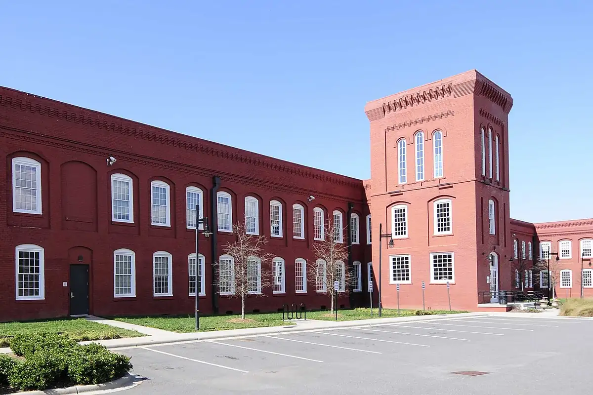
Winthrop Normal and Industrial College moved to Rock Hill in 1895, and two Black junior colleges opened in the same decade, Friendship in 1891 and Clinton College in 1894, according to the encyclopedia. In the 1960s, the ACHP notes, Rock Hill was the site of one of the first sit-ins against segregation. The old Cotton Factory, in the photo below, closed as a mill and was redeveloped in 2006 and 2007.
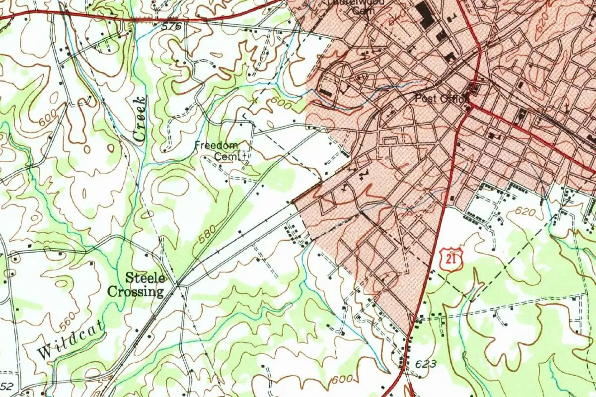
The 1949 map at the top of this page shows a grown city: a grid of streets shaded pink, the post office, Laurelwood Cemetery and U.S. Route 21 heading south. The brown contour lines in this crop are labeled from 560 to 640 feet (171 to 195 m). You won’t find a label for the knoll in it, so the map can’t tell you which rise, if any, is the one on the supervisor’s note.
South Carolina has other names that came off the railroad: Branchville has a railroad branch in one of its two stories, and Florence honors a railroad president’s daughter. There’s more on our South Carolina page.
Quick answers
Why is Rock Hill, SC, called Rock Hill?
Because of a small rocky rise in the railroad’s path. The South Carolina Encyclopedia says the name came from a notation on a construction supervisor’s map marking where the Charlotte and South Carolina Railroad met “a small, flinty knoll.”
Who founded Rock Hill?
Alexander Templeton Black is the person the South Carolina Encyclopedia says “became known as the founding father of Rock Hill,” because he let the railroad cross his plantation. The name, though, came from the map, not from him.
Was Rock Hill incorporated in 1870 or 1892?
Both, in a way. The General Assembly incorporated the town on February 26, 1870, and Rock Hill was rechartered as a city on December 24, 1892.
Why didn’t the railroad go through Ebenezer?
Its residents objected. The encyclopedia says Ebenezer’s citizens didn’t want the smoke and noise of the trains, so the railroad was built elsewhere.
Key dates
- 1852Rock Hill begins as a depot and watering station on the Charlotte and South Carolina Railroad; its post office opens on April 17.
- 1869Residents petition the legislature to incorporate the town.
- 1870The General Assembly incorporates Rock Hill on February 26.
- 1880The Rock Hill Cotton Factory opens.
- 1892Rock Hill is rechartered as a city on December 24.
Things to do in Rock Hill, South Carolina
Museum of York County
A natural history museum of the Carolina Piedmont, with the Naturalist Center and its more than 2,000 specimens, the Settlemyre Planetarium, and gardens and a nature trail out back.
Glencairn Garden
An award-winning garden of 11 acres that has been on display for more than 50 years, with a Veterans Garden, tiered fountains, ponds, boardwalks, and azaleas, dogwoods and wisteria in spring.
McCrory's lunch counter and the Freedom Walkway
The original lunch counter where the Friendship 9 sat in on January 31, 1961, restored in 2020, with a state historical marker outside and the Freedom Walkway mural in the alley nearby.
Old Town Rock Hill
Main Street and the historic blocks around it, with locally owned restaurants, breweries, shops and an arts community.
Catawba Indian Nation Cultural Center
The cultural center of the Catawba Indian Nation in York County, with exhibits, walking trails and an artisan shop selling pottery and jewelry by Native artisans.
Getting there
Open Rock Hill in Google Maps
Opens in a new tab. The pin is the center of Rock Hill in the USGS place-name record.
The closest airports, Amtrak stations and intercity bus stops, measured in a straight line from the center of Rock Hill.
Airports
- Charlotte/Douglas International (CLT) 20 mi 33 km
- Concord-Padgett Regional (JQF) 37 mi 59 km
Amtrak trains
- Charlotte station (CLT) 25 mi 40 km
- Gastonia station (GAS) 25 mi 40 km
Intercity buses
- OurBus Charlotte, NC (Charlotte Douglas International Airport - At the arrival zone of the airport, follow the signs that say buses. The bus will stop near pillar 2 in the charter bus area) 21 mi 34 km
- Sunway Charters Charlotte 23 mi 38 km
- Barons Bus Lines Charlotte 23 mi 38 km
Distances are as the crow flies, not by road. We don't list schedules or fares because they change; check with the airline, Amtrak or the bus company before you go. Official data (FAA commercial service airports (2025), FAA airport locations, Amtrak stations and Intercity Bus Atlas) from the FAA and the U.S. Bureau of Transportation Statistics, checked Nov 14, 2026.
Sponsored
Staying in Rock Hill?
Compare hotels in Rock Hill, South Carolina, on Expedia.
See hotels in Rock HillWe may earn a commission if you buy through this link. It never changes what we write. Read our affiliate disclosure
Historical Sources & References
- Matthew A. Lockhart, “Rock Hill,” South Carolina Encyclopedia. The depot and watering station of 1852; the “notation on a construction supervisor’s map” and the “small, flinty knoll”; Ebenezer and Alexander Templeton Black; the twenty-three lots on “Main”; the post office of April 17, 1852; the 1869 petition and the “transient and floating” objection; incorporation on February 26, 1870; James Morrow Ivy, the Lantern and the Herald; the Cotton Factory as the first steam-powered textile mill in the upcountry; the mills of 1890 and 1896; the city charter of December 24, 1892; Winthrop, Friendship and Clinton colleges.
- Advisory Council on Historic Preservation, “Rock Hill, South Carolina”. The Catawba and the “Indian Land” settled from the 1730s, about 15 miles south of Charlotte; the direct route from Charlotte to Columbia and what engineers termed “rocky hill” on the company’s rail map; better cotton prices along the line; the Cotton Factory as the first steam-powered mill in South Carolina and its redevelopment in 2006-2007; the 1960s sit-in.
- GNIS feature 1250417 (U.S. Geological Survey). The gazetteer entry for Rock Hill, York County, with its coordinates.
- U.S. Geological Survey, Rock Hill sheet (1949). The 1:62,500 map that the image at the top of this page was cropped from.
Spot something wrong, or know more? Tell us here. You can also email us or use our contact page. Corrections are noted here with their date, never made silently.