Chincoteague, Virginia: What the Island's Name Means
Chincoteague is an Indian name for the island and its inlet. The 1907 Handbook of American Indians glosses it as 'large stream' or 'inlet,' crediting Hewitt. The Town of Chincoteague says the name is said to mean 'beautiful land across the water.' Merriam-Webster gives SHING-kuh-teeg, and the 1940 WPA guide wrote shin-ca-teeg.
Chincoteague, Virginia, has an Indian name a 1907 handbook glossed as large stream or inlet; the town says it means beautiful land across the water. You’ll find both readings in print. The handbook, the WPA guide, the town and the island museum all call it an Indian name. What it meant is the part you’ll find told two ways.
Two translations for one name
The older one comes from the Bureau of American Ethnology’s Handbook of American Indians North of Mexico, published in 1907. Its entry glosses the name as “‘large stream,’ ‘inlet,’” and credits that reading to Hewitt, one of the handbook’s writers. The entry describes a village “probably belonging to the Accohanoc tribe of the Powhatan confederacy, formerly about Chincoteague inlet in Accomack co., Va.” The handbook credits Hewitt with other readings too, among them Cayahoga, a village on Ohio’s Cuyahoga River, as “the fork of the stream.”
The Writers’ Program guide to Virginia, published in 1940, gives the same reading. It puts it in the entry for Chincoteague Crossroads, on the mainland: “Ind. large stream, inlet; pronounced shin-ca-teeg.”
The town tells it differently. “The word ‘Chincoteague’ is said to be an Indian name meaning ‘beautiful land across the water,’” the Town of Chincoteague’s history page says. The Museum of Chincoteague Island goes further and drops the “said to be”: “Chincoteague translates to ‘beautiful land across the water.’”
Neither the town nor the museum names a linguist or an older source for that translation. The handbook gives a name, Hewitt, but no more than a line. So this page lists the origin as disputed: the name is Indian, and its meaning has two versions with support.
The spellings in the old records
Colonial records spell the name several ways. The handbook lists Chingoteacq on Herrman’s map of 1670 and Gingo-teque in Beverly’s Virginia of 1722. The town adds that “Court records in 1671 indicate a spelling of ‘Jungoteague’” and that a reference from the early 1800s has “Gingoteag.”
The WPA guide records an earlier use. “On October 25, 1662, Chincoteague Island was granted to Captain William Whitington by Wachawampe, Emperor of the Gingo Teagues, and regranted twice later,” it says. In that sentence the name belongs to a people as well as a place.
Who lived here
The sources don’t line up neatly on this either. The handbook places the village “about Chincoteague inlet” and says that “In 1722 the few remaining inhabitants had joined a Maryland tribe.” The island museum says that “Native Americans did not live on Chincoteague Island,” but “regularly traveled to the Island by boat to harvest shellfish,” and that the island’s indigenous name “is still used today.”
The U.S. Fish and Wildlife Service says the refuge next door sits “on the Indigenous homelands of the Pocomoke and Occohannock people.” That Pocomoke name is also on a river and a town in Maryland, Pocomoke City.
From grazing land to a town
According to the town, the island was used to graze livestock in the 1600s, and families were living there year-round by 1800. Its seafood went to markets in New York and Philadelphia. The town was incorporated in 1908.
The town says the causeway to the mainland was finished in 1922 and a bridge to Assateague Island followed in 1962. Tourism is now its main industry. The wildlife refuge next door was set up in 1943 to protect migratory birds. A last annexation, in 1989, brought the whole island inside the town limits.
How to say it
Merriam-Webster lists Chincoteague as the name of an oyster, taken “from Chincoteague Bay on the Maryland-Virginia coast,” and gives \¦shiŋkə¦tēg, with \¦chiŋ-\ as another way to start it. That’s SHING-kuh-teeg. The 1940 WPA guide spelled it out as “shin-ca-teeg.”
The 1943 map
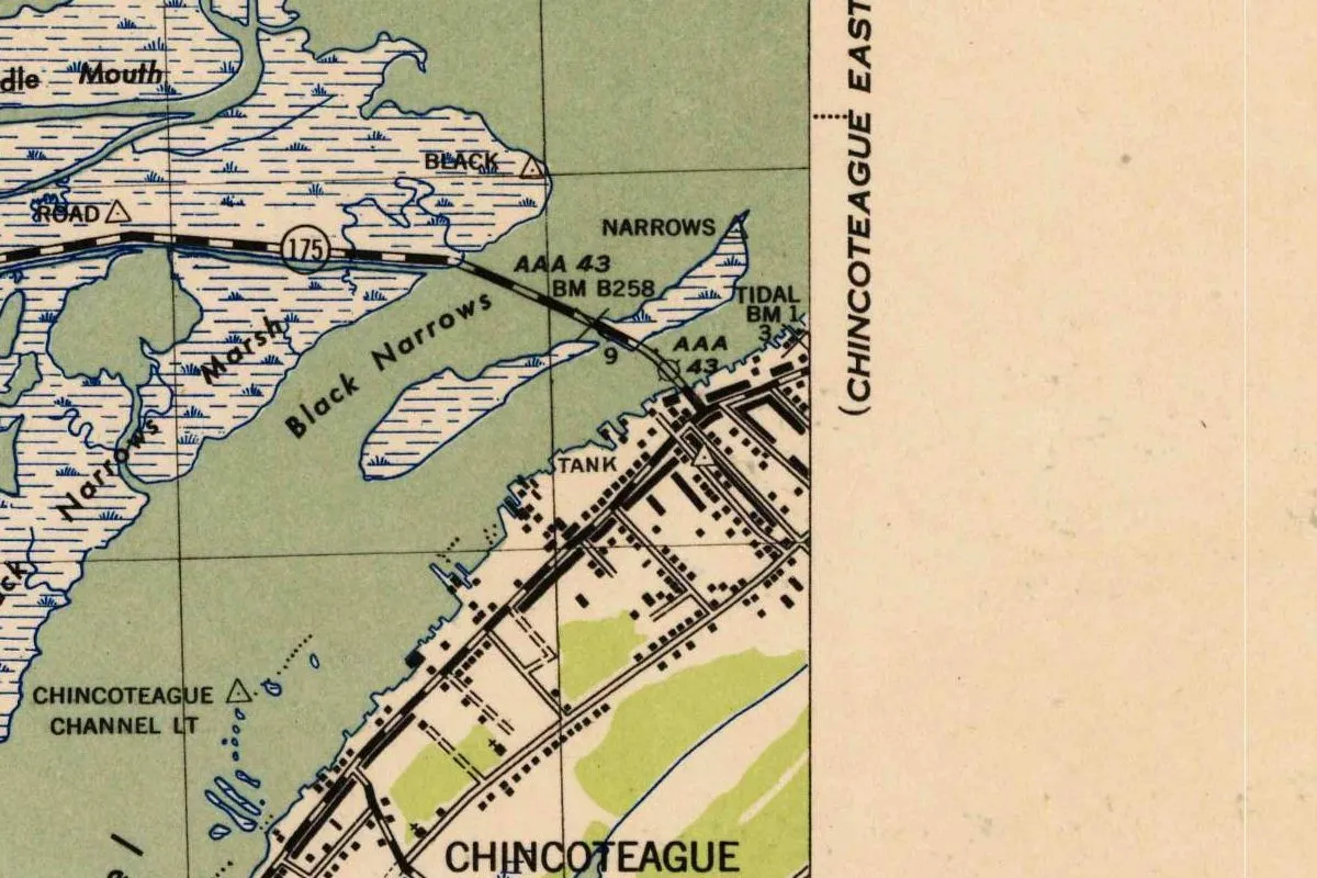
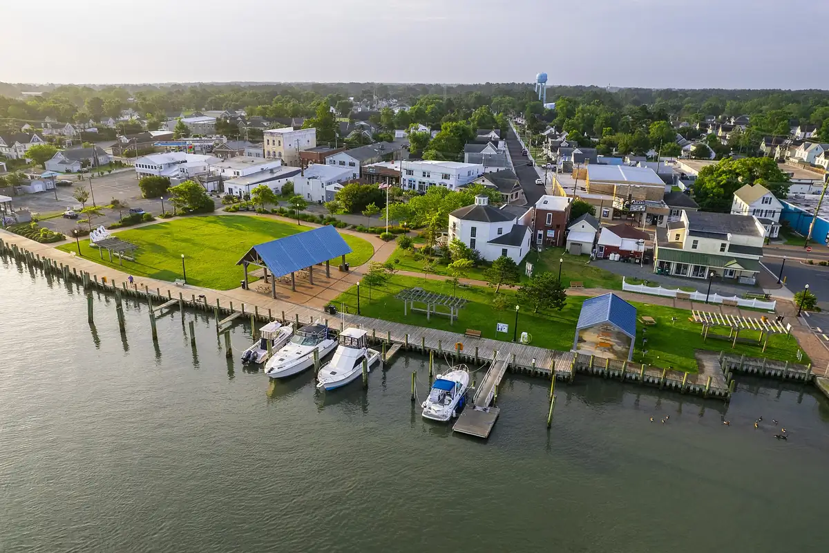
The map at the top of this page is a corner of the Chincoteague West sheet, drawn for the War Department in 1943, with topography and field edit by the U.S. Coast and Geodetic Survey that year. You can see Route 175 come in from the west on its causeway, cross the channel called Black Narrows and land at the north end of town. The street grid runs along the island’s western shore. The photo below shows that same bay side from the air.
Quick answers
What does Chincoteague mean?
The 1907 Handbook of American Indians glosses it as “large stream” or “inlet,” credited to Hewitt. The Town of Chincoteague says it is said to mean “beautiful land across the water,” and the island museum gives the same translation.
How do you pronounce Chincoteague?
Merriam-Webster gives \¦shiŋkə¦tēg, or SHING-kuh-teeg, and also lets it start with CHING. The 1940 WPA guide wrote “shin-ca-teeg.”
Did Native Americans live on Chincoteague Island?
The handbook describes a village, probably Accohanoc, about Chincoteague inlet. The island museum says Native Americans didn’t live on the island but came by boat to harvest shellfish.
When did Chincoteague get a causeway?
The Town of Chincoteague says the causeway to the mainland was completed in 1922.
Key dates
- 1662On October 25, the WPA guide says, Wachawampe, 'Emperor of the Gingo Teagues,' grants the island to Captain William Whitington.
- 1670Herrman's map spells the name Chingoteacq, according to the Handbook of American Indians.
- 1671Court records spell it Jungoteague, the Town of Chincoteague says.
- 1722The few people left in the village on Chincoteague inlet have joined a Maryland tribe, the Handbook says.
- 1908The Town of Chincoteague is incorporated.
- 1922The causeway to the mainland is completed.
- 1943Chincoteague National Wildlife Refuge is established to protect migratory birds.
- 1962A bridge links Chincoteague to Assateague Island.
- 1989The last annexation makes the whole island part of the town.
Things to do in Chincoteague, Virginia
Museum of Chincoteague Island
A museum with exhibits on the island's first people, decoy carving, the seafood trade and Misty of Chincoteague. It also keeps the original first-order Fresnel lens from the Assateague Lighthouse.
Chincoteague National Wildlife Refuge
Established in 1943 to protect migratory birds, the refuge next to town has 15 miles (24 km) of hiking trails, a beach and more than 275 bird species, the Fish and Wildlife Service says. The town is its gateway.
Woodland Trail pony overlook
A 1.6-mile (2.6 km) trail in the refuge with an overlook where you can look for the Chincoteague ponies.
Assateague Lighthouse
The lighthouse stands in the refuge at the end of the Lighthouse Trail, a quarter mile (0.4 km) walk. Its first-order lens is now at the island museum in town.
Assateague Island National Seashore
The National Park Service manages the barrier island's beaches, salt marshes and maritime forest, home to wild horses, with camping and kayaking.
Getting there
Open Chincoteague in Google Maps
Opens in a new tab. The pin is the center of Chincoteague in the USGS place-name record.
The closest airports, Amtrak stations and intercity bus stops, measured in a straight line from the center of Chincoteague.
Airports
- Salisbury-Ocean City Wicomico Regional (SBY) 29 mi 47 km
- Newport News/Williamsburg International (PHF) 82 mi 133 km
- Norfolk International (ORF) 85 mi 136 km
Amtrak trains
- Newport News station (NPN) 84 mi 135 km
- Williamsburg station (WBG) 86 mi 138 km
Intercity buses
- Greyhound Oak Hall T'S Corner Exxon 9 mi 14 km
- FlixBus Salisbury Park & Ride 31 mi 50 km
- BayRunner Shuttle Ocean City 31 mi 51 km
Distances are as the crow flies, not by road. We don't list schedules or fares because they change; check with the airline, Amtrak or the bus company before you go. Official data (FAA commercial service airports (2025), FAA airport locations, Amtrak stations and Intercity Bus Atlas) from the FAA and the U.S. Bureau of Transportation Statistics, checked Nov 17, 2026.
Sponsored
Staying in Chincoteague?
Compare hotels in Chincoteague, Virginia, on Expedia.
See hotels in ChincoteagueWe may earn a commission if you buy through this link. It never changes what we write. Read our affiliate disclosure
Historical Sources & References
- Frederick Webb Hodge, ed., Handbook of American Indians North of Mexico, Part 1 (1907), p. 272. The gloss “large stream,” “inlet,” credited to Hewitt; the village “probably” Accohanoc; the people left in 1722; Herrman’s and Beverly’s spellings. Checked against the page image.
- Writers’ Program, Virginia: A Guide to the Old Dominion (1940), pp. 375-376. “Ind. large stream, inlet; pronounced shin-ca-teeg,” and the grant of October 25, 1662, by Wachawampe. Checked against the page images.
- Town of Chincoteague, “About Our Island”. “Beautiful land across the water,” the 1671 and early-1800s spellings, the grazing, the incorporation of 1908, the causeway of 1922, the bridge of 1962 and the annexation of 1989.
- Museum of Chincoteague Island, “Exhibits”. The museum’s translation, the shellfish trips by boat and the Assateague lens.
- Merriam-Webster, “Chincoteague”. The pronunciation.
- U.S. Fish and Wildlife Service, Chincoteague National Wildlife Refuge. The Pocomoke and Occohannock homelands and the founding in 1943.
- Refuge cultural heritage page; Assateague Island National Seashore. The details in the things-to-do list.
- GNIS feature ID 1492764 (U.S. Geological Survey). Chincoteague’s place in the national names database, in Accomack County, with its coordinates.
- War Department, Chincoteague West sheet (1943). The 1:31,680 map, from the U.S. Geological Survey’s historical collection, that the image at the top of this page was cropped from.
Spot something wrong, or know more? Tell us here. You can also email us or use our contact page. Corrections are noted here with their date, never made silently.