Hackberry, Arizona: The Shade Tree Behind a Route 66 Name
Hackberry, Arizona, took its name from a silver mine, and the mine took its name from one big hackberry tree that sheltered the prospectors in 1874. That’s how Hiram C. Hodge told it in his 1877 book Arizona as It Is, and Will C. Barnes’s Arizona Place Names traced the town to the same mine in 1935.
A tree by Hackberry spring
Hodge built his book from notes of travel in 1874, 1875 and 1876. He put the Peacock Mountains about 25 miles (40 km) east of the Cerbat Range, across the Hualapai Valley, and singled out one lode there for “a full and special mention”:
“In October, 1874, William Ridenour, S. Crozier, and two others parties discovered a wonderful rich lode, which they named the Hackberry Mine, in honor of a large hackberry tree near a spring of the same name. This tree gave them shelter and shade, and under its protecting branches they made their home for many weeks.”
Notice that he gives the spring the same name. He doesn’t say which got it first, the spring or the mine. What he’s clear about is the tree: Ridenour, Crozier and their two partners lived under it for weeks.
The find came after a rough season, by Hodge’s account. The party had gone prospecting north toward the Grand Canyon, where he says they were attacked by Indians and lost their animals, tools, food and clothes. They straggled into Mineral Park “nearly dead with fatigue and hunger,” rested a few days and went out again. That’s the trip that turned up the Hackberry.
In the papers by 1875
The name reached print before Hodge’s book did. On April 2, 1875, a letter from Hardyville in Prescott’s Arizona Weekly Miner said a new mill would “also work ore from the Hackberry mine.” Six weeks later, Tucson’s Arizona Citizen reported that a lode “was located last Fall by Ridenour & Co., and named the Hackberry,” and that its owners had kept quiet while they tested it. Neither paper explained the name, but the Citizen’s “last Fall” lines up with Hodge’s October 1874.
The mine paid. Hodge says the discoverers split the lode into two claims, the Hackberry and the Hackberry South, and that a five-stamp mill went up “near the Hackberry spring” in the winter of 1875-76, finished in March 1876. He also says he examined the mine in person. By the time he wrote, he could list Hackberry among the county’s towns: “a new and prospering mining town in the Peacock Mountains, thirty miles east of Mineral Park,” with about 100 people, a few stores, restaurants and saloons.
What Barnes added, and what he guessed
When Barnes compiled his gazetteer of Arizona names for the University of Arizona in 1935, his Hackberry entry gave the same chain in one line, in quotation marks but without saying who gave it to him: the town was named “For the Hackberry mine which took its name from a large hackberry tree near a spring where the camp was.” So you get the same tree and the same spring, with one small difference. Barnes’s line doesn’t say the spring was called Hackberry.
He also dated the post office: established July 9, 1878, with Alonzo E. Davis as postmaster. And he tried to go further back. “As nearly as the author can work it out,” he wrote, the spring was “Beale’s ‘Garden Spring,’” meaning Lt. E. F. Beale, the explorer who surveyed a wagon road from Fort Smith, Arkansas, to the Colorado River in 1858-59. But the entry he sends you to is spelled Gardiner Spring, and there Barnes quotes Beale naming it “After one of my men who showed it to me,” somewhere not far from Truxton Spring. Barnes didn’t claim more than a best guess, and neither do we.
Two Hackberrys on the 1886 map
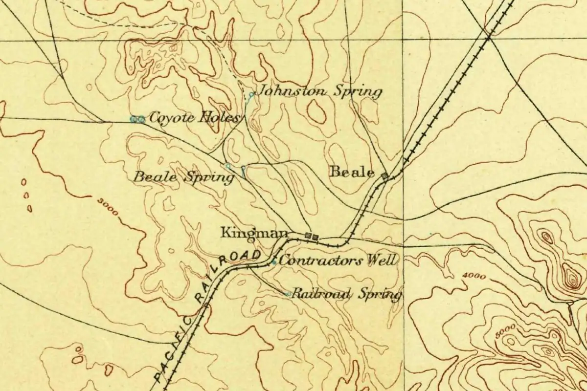
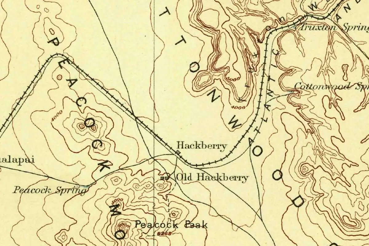
The U.S. Geological Survey’s 1886 map at the top of this page shows two of them. Hackberry is a single square on the railroad, the line marked “Atlantic” as it curves through the hills. Old Hackberry is a few squares just to the south, near the foot of the Peacock Mountains. The map doesn’t explain the split beyond that one word, “Old.” By 1935, Barnes was listing Hackberry as a town on the Santa Fe railroad.
Across the tracks from Route 66
If you’d driven US 66 in 1940 with the WPA’s new Arizona guide in your lap, it wouldn’t have told you anything about Hackberry. Its Tour 2 goes from Valentine, at mile 81.1, straight to Kingman, at mile 114.5, without a word about the place in between.
Jack Rittenhouse’s Guide Book to Highway 66 didn’t skip it in 1946. He gave Hackberry 94 people and an altitude of 3,552 feet, and he made a point worth knowing: “The town of Hackberry lies down in the valley across the railroad tracks”. On the highway side, he counted three gas stations and a lunchroom. He also noted several large tanks in town holding diesel oil for the railroad’s locomotives.
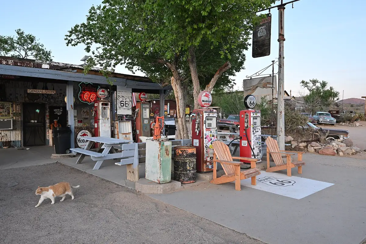
Nearly 60 years later, the photographer Carol M. Highsmith made the same distinction. The note with her September 25, 2004, photo of the Hackberry General Store, now at the Library of Congress, says “The actual town of Hackberry lies across the tracks from Route 66, but the Hackberry General Store is right on the old road.” The same note tells the name story in short form: “A large Hackberry tree grew by the spring and gave the town its name.” It leaves out the mine, which Hodge and Barnes both put in the middle. It also says the ore played out “but the town of Hackberry hung on.”
Hackberry sits about 22 miles (36 km) northeast of Kingman in a straight line. None of the sources we read says what became of the tree. You’ll see a big leafy one in front of the store in the photo below, but nothing we found says it’s a hackberry, let alone the same one. As far as our sources go, the tree behind the name lives on only on paper, in Hodge’s book, Barnes’s gazetteer and a photo caption.
Quick answers
Why is Hackberry, Arizona, called Hackberry?
Because of the Hackberry mine, Barnes says. Hodge wrote in 1877 that the prospectors who found it in October 1874 named it “in honor of a large hackberry tree near a spring of the same name.”
Who named the Hackberry mine?
William Ridenour, S. Crozier and two partners, according to Hodge. A Tucson paper in May 1875 also credited the find to “Ridenour & Co.”
Is the Hackberry General Store the old town?
No. Rittenhouse’s 1946 guide and a 2004 Library of Congress photo note both put the town across the railroad tracks from Route 66, while the store sits on the old road.
Is Hackberry a ghost town?
Not by our sources. The 2004 Library of Congress note says the town “hung on” after the ore played out, and Rittenhouse counted 94 people in 1946. We didn’t find a recent population figure.
Key dates
- 1874In October, William Ridenour, S. Crozier and two partners find a lode and name it the Hackberry Mine, for a large hackberry tree near a spring.
- 1875The Hackberry mine is in the Arizona papers by April; in May a Tucson paper credits the find to "Ridenour & Co."
- 1876A five-stamp mill near the Hackberry spring is finished in March.
- 1877Hiram C. Hodge calls Hackberry "a new and prospering mining town" of about 100 people.
- 1878A Hackberry post office opens on July 9, with Alonzo E. Davis as postmaster, according to Barnes.
- 1886A U.S. Geological Survey map shows Hackberry on the railroad and Old Hackberry just to the south.
- 1946Jack Rittenhouse's Route 66 guide gives Hackberry 94 people and puts the town across the tracks from the highway.
- 2004Carol M. Highsmith photographs the Hackberry General Store on the old road.
Getting there
Open Hackberry in Google Maps
Opens in a new tab. The pin is the center of Hackberry in the USGS place-name record.
The closest airports, Amtrak stations and intercity bus stops, measured in a straight line from the center of Hackberry.
Airports
- Grand Canyon West (1G4) Peach Springs 43 mi 69 km
- Laughlin/Bullhead International (IFP) Bullhead City 49 mi 79 km
- Harry Reid International (LAS) Las Vegas 94 mi 151 km
Amtrak trains
- Kingman station (KNG) 22 mi 36 km
- Needles station (NDL) 62 mi 99 km
Intercity buses
- Greyhound Kingman McDonald's 19 mi 30 km
- Vegas Airporter Amtrak Connecting Service · Kingman 22 mi 36 km
- FlixBus Kingman N 23 mi 37 km
Distances are as the crow flies, not by road. We don't list schedules or fares because they change; check with the airline, Amtrak or the bus company before you go. Official data (FAA commercial service airports (2025), FAA airport locations, Amtrak stations and Intercity Bus Atlas) from the FAA and the U.S. Bureau of Transportation Statistics, checked Nov 11, 2026.
Sponsored
Staying in Hackberry?
Compare hotels in Hackberry, Arizona, on Expedia.
See hotels in HackberryWe may earn a commission if you buy through this link. It never changes what we write. Read our affiliate disclosure
Historical Sources & References
- Hiram C. Hodge, Arizona as It Is; or, The Coming Country (1877). pp. 87-88: the Peacock Mountains “about twenty-five miles east of the Cerbat Range”; the October 1874 discovery by William Ridenour, S. Crozier “and two others parties,” named “in honor of a large hackberry tree near a spring of the same name”; the tree’s “shelter and shade”; the earlier trip toward the Grand Canyon and the arrival at Mineral Park; the Hackberry and Hackberry South claims; the five-stamp mill “near the Hackberry spring,” finished in March 1876. pp. 89-90: silver bullion and the author’s “personal examination.” pp. 146-147: Hackberry, “a new and prospering mining town,” 30 miles east of Mineral Park, population about 100, with “a few stores, restaurants, and saloons.”
- Will C. Barnes, Arizona Place Names (1935). p. 194, entry “Hackberry”: town on the A. T. & S. F. railroad on Truxton Wash, east side of the Peacock Mountains; “For the Hackberry mine which took its name from a large hackberry tree near a spring where the camp was”; “As nearly as the author can work it out this is Beale’s ‘Garden Spring’”; post office established July 9, 1878, Alonzo E. Davis, postmaster. p. 40, entry “Beale Spring”: Lieut. E. F. Beale, “the explorer,” and his wagon-road survey from Fort Smith to the Colorado River, 1858-59. p. 173, entry “Gardiner Spring”: Beale’s “After one of my men who showed it to me,” not far from Truxton Spring, “See Hackberry.” University of Arizona Repository scan.
- “Letter from Hardyville,” Arizona Weekly Miner (April 2, 1875). p. 1: a new mill at Mineral Park “will also work ore from the Hackberry mine.” The earliest mention of the name we found in Chronicling America.
- Arizona Citizen (May 15, 1875). p. 1: “a lode was located last Fall by Ridenour & Co., and named the Hackberry.”
- Writers’ Program, Arizona: A State Guide (1940). Tour 2 (US 66), pp. 323-324: Valentine at 81.1 miles, then Kingman at 114.5 miles, with no entry for Hackberry.
- Jack D. Rittenhouse, A Guide Book to Highway 66 (1946). Entry “Hackberry”: population 94, altitude 3,552 feet; “The town of Hackberry lies down in the valley across the railroad tracks”; the diesel tanks; three gas stations and a lunchroom on US 66. Read through archive.org’s full-text search; page number not seen.
- Carol M. Highsmith, “Hackberry General Store, Route 66, Hackberry, Arizona” (September 25, 2004), Library of Congress. Catalog note: the town was founded after prospectors found ore in the 1870s; “A large Hackberry tree grew by the spring and gave the town its name”; the ore played out “but the town of Hackberry hung on”; the town lies across the tracks, the store “right on the old road.”
- U.S. Geological Survey, Diamond Creek sheet (1886). The map at the top of this page, the oldest in the USGS historical collection that shows Hackberry, with Old Hackberry to the south.
- GNIS feature 5466, Hackberry (U.S. Geological Survey). The populated-place entry for Hackberry in Mohave County, on the Hackberry map sheet, with its coordinates.
Sponsored
Gear up for your next road trip
Explore rooftop tents, vehicle awnings and outdoor gear from TOPOAK Overland.
Shop TOPOAK overlanding gearWe may earn a commission if you buy through this link. It never changes what we write. Read our affiliate disclosure
Spot something wrong, or know more? Tell us here. You can also email us or use our contact page. Corrections are noted here with their date, never made silently.