Why Is It Called Siesta Key? A 1907 Sales Pitch
Harry L. Higel and partners in the Siesta Land Company, formed in 1907, named their new town on the north end of the island Siesta. The name spread to the whole key. Federal mapmakers still called it Sarasota Key, until the U.S. Board on Geographic Names switched to Siesta Key in 1952, announcing it in 1954.
Siesta Key, Florida, takes its name from Siesta, a town platted in 1907 by Harry Higel’s land company; the island was Sarasota Key until the 1950s. For decades you could pick either name and find a map to back you up.
Why is it called Siesta Key?
It started as a real estate name. Karl H. Grismer, in The Story of Sarasota (1946), credits a local promoter, Harry L. Higel, whom he calls “A fiery, outspoken man”: “It was Higel who gave Siesta Key its name—it had formerly been called Sarasota Key.” In 1907, Grismer writes, Higel formed the Siesta Land Company with Capt. Louis Roberts, who ran the Roberts Hotel on the key, and E. M. Arbogast, a winter visitor from Marlington, West Virginia. The three “platted the town of Siesta” and started advertising.
The ads didn’t hold back. Grismer quotes one that called Siesta a new town in “the prettiest spot in the world,” with streets laid out to the Gulf, where “surf bathing and shell gathering has no equal.” Later in the book, telling Roberts’ story, he explains the word itself: the company platted “the subdivision of Siesta—‘a wonderful place to rest.’”
Sarasota County’s own history of the beach pavilions tells the 1907 part the same way. In its account, the partners’ company laid out “Siesta on the Gulf” on the island’s northern tip, dredged the bayous and put in docks, while Higel kept the Siesta post office and put up a hotel, the Higelhurst.
It didn’t take off right away. Grismer says the panic of 1907 “killed the Siesta venture for a time,” and the town was platted again in 1912. The county report adds that the 1910 census found just 31 people on the key.
Sarasota Key or Siesta Key?
At first, Siesta was only the north end. Grismer says that after the company was formed, Roberts renamed his place the Siesta Hotel, “and the name of the north end of Sarasota Key also was changed to Siesta.” The island as a whole kept the older name it shared with Sarasota and its bay. Grismer adds that a government map of 1839, drawn for Gen. Zachary Taylor, had called it Clam Island, and that later federal maps used Sarasota Key.
In 1922 the federal government made the old name official. Asked by the Hydrographic Office, the U.S. Geographic Board approved “Sarasota” for the key south of Big Sarasota Pass on February 1, 1922. It turned down “Little Sarasota Key,” a local name it said came from the bay to the east, not the island’s size, calling it “a misnomer.” The board pointed to Coast and Geodetic Survey records using Sarasota Key since 1883.
So in 1946 Grismer could write that the whole island “is called Sarasota Key on government maps and Siesta Key on the county map,” and then shrug: “if you like one name better than the other, take your choice and you will have proof that you are right.”
The local name won anyway. The county report says “Siesta” gradually spread to the whole key. The Board on Geographic Names’ decision 659 describes Siesta Key as an island about 6.5 miles (10.5 km) long between Big Sarasota Pass and Midnight Pass, lists “Not: Little Sarasota Key, Sarasota Key,” and notes “1922 BGN decision revised.” Stamps on the card show it was approved in September 1952, and it was promulgated in June 1954. A 1974 New College report puts the change on July 3, 1952, without naming a source for that day.
It’s not the only island where the board had to choose a name. In 1940 it ruled on Jekyll Island, Georgia, picking two l’s over the old Jekyl that maps had used for generations.
Siesta Key history: Roberts, Higel and a bridge
Louis Roberts came early, and he stayed. Grismer says Roberts, born in Key West, sailed up the coast in a small fishing boat in 1878, married Ocean Hanson, and filed a homestead claim on the key nearly across the bay from her family’s land. He fished, raised a family, began taking in winter guests about 1900, and about 1906 started calling his enlarged house the Roberts Hotel.
The real change came with a bridge. Grismer writes that the Siesta Key bridge was finished on March 2, 1917, though it wasn’t formally opened until May 1. Before that, none of the keys off Sarasota had a direct link to the Florida mainland, he says, and the county report says it was the bridge that finally brought residents and tourists out to the beaches. The same report says the county’s first pavilion at Siesta Beach opened with a dedication in spring 1960.
Another Gulf beach owes its name to a developer, too. In Gulf Shores, Alabama, George C. Meyer named the beach after Miami Shores, his widow said, and got a mapmaker to drop the older label.
Siesta Key on the 1944 map
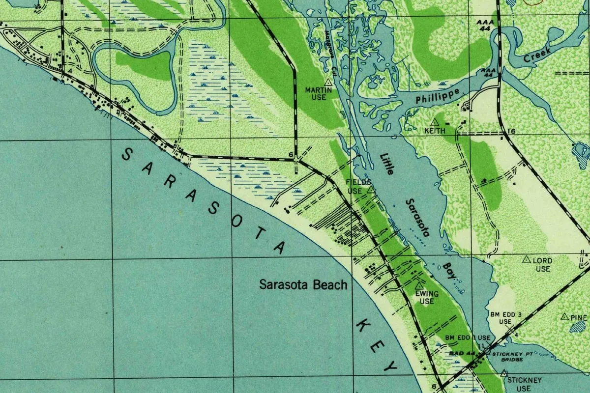
The map at the top was cropped from the Sarasota quadrangle, 7½-minute series, at 1:31,680. It was made by the Coast and Geodetic Survey under the Army’s Chief of Engineers in 1942, with planimetry from 1942 air photos and field work in 1944, and the sheet is marked “Edition of 1944.”
In the crop, “Sarasota Key” is spelled out in widely spaced letters along the Gulf, the same name Grismer was talking about two years later. Little Sarasota Bay and Phillippe Creek are on the mainland side, and a bridge marked Stickney Pt Bridge crosses to the mainland. Off to the north, beyond the crop, the sheet gives the key’s northern tip its own label, Siesta, next to a bridge marked Siesta Br.
Quick answers
Who named Siesta Key?
Harry L. Higel, according to Grismer’s 1946 history, through the Siesta Land Company he formed in 1907 with E. M. Arbogast and Louis Roberts.
What does Siesta mean?
Rest. Grismer glosses the name of the 1907 subdivision, Siesta, as “a wonderful place to rest.”
When did Sarasota Key become Siesta Key?
In 1952, when the Board on Geographic Names approved the change, revising its 1922 ruling; the decision was promulgated in June 1954.
Key dates
- 1839A government map made for Gen. Zachary Taylor calls the island Clam Island, Grismer writes.
- 1878Louis Roberts of Key West arrives; he and his wife later homestead on what was then Sarasota Key.
- 1907Harry Higel, Louis Roberts and E. M. Arbogast form the Siesta Land Company and plat the town of Siesta.
- 1912After the panic of 1907 stalls the venture, the town of Siesta is platted again.
- 1917The first bridge from the mainland is finished on March 2 and formally opened on May 1.
- 1922The U.S. Geographic Board adopts Sarasota for the key and rejects Little Sarasota Key.
- 1944The Sarasota quadrangle letters the island Sarasota Key and its north end Siesta.
- 1952The Board on Geographic Names approves Siesta Key, revising its 1922 decision.
- 1954The Siesta Key decision is promulgated in June.
- 1960The first county pavilion at Siesta Beach is dedicated in the spring.
Things to do in Siesta Key, Florida
Siesta Beach
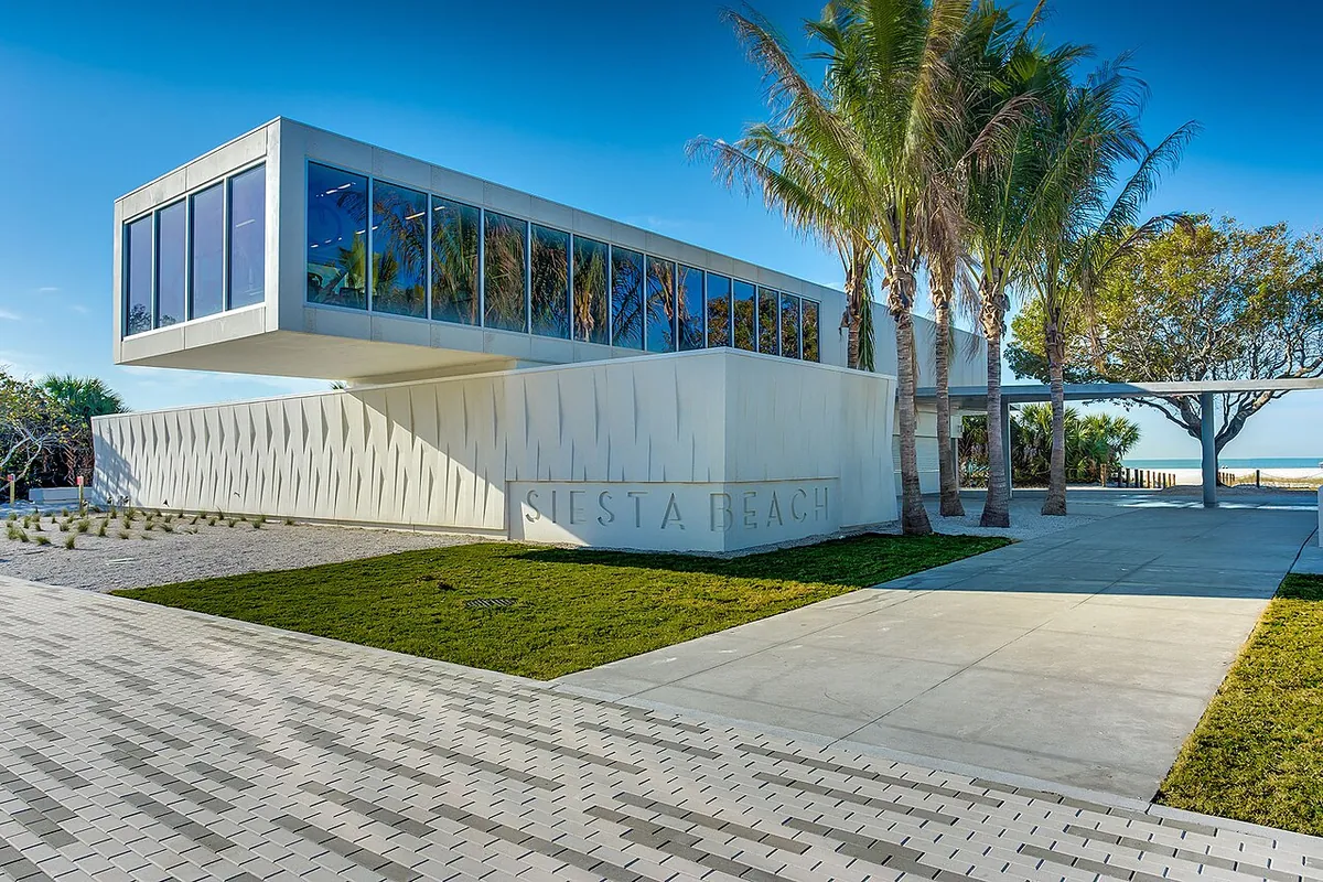
The county's big public beach, known for sand that's nearly all quartz. A 2016 renovation added a playground, an esplanade about half a mile (0.8 km) long, and a renovated pavilion from the Sarasota School of Architecture.
Turtle Beach Campground
A small county campground on Siesta Key, with 39 RV and tent sites a short walk from Turtle Beach. The county says few campgrounds in the state put you right on the sand like this.
Siesta Key Village
Siesta Village, the island's cluster of boutiques, bars and restaurants, for shopping and dinner after a day on the sand.
Point of Rocks
The far south end of Crescent Beach, a quieter spot to unwind away from the crowds, and a spot where you can snorkel or fish.
Nora Patterson Bay Island Park
A city park tucked under the north bridge to Siesta Key, looking across to downtown Sarasota, with places to sit, eat outside, fish or walk.
Getting there
Open Siesta Key in Google Maps
Opens in a new tab. The pin is the center of Siesta Key in the USGS place-name record.
The closest airports, Amtrak stations and intercity bus stops, measured in a straight line from the center of Siesta Key.
Airports
- Sarasota/Bradenton International (SRQ) 6 mi 10 km
- St Pete-Clearwater International (PIE) 43 mi 69 km
- Tampa International (TPA) 47 mi 75 km
Amtrak trains
- Tampa station (TPA) 45 mi 73 km
- Lakeland station (LAK) 63 mi 102 km
Intercity buses
- Amtrak Chartered Vehicle Amtrak Connecting Service · Sarasota Amtrak Bus Stop 6 mi 10 km
- FlixBus Sarasota Cattlemen Bus Station 6 mi 10 km
- Greyhound St Petersburg Psta Transit Center 38 mi 61 km
Distances are as the crow flies, not by road. We don't list schedules or fares because they change; check with the airline, Amtrak or the bus company before you go. Official data (FAA commercial service airports (2025), FAA airport locations, Amtrak stations and Intercity Bus Atlas) from the FAA and the U.S. Bureau of Transportation Statistics, checked Nov 18, 2026.
Sponsored
Staying in Siesta Key?
Compare hotels in Siesta Key, Florida, on Expedia.
See hotels in Siesta KeyWe may earn a commission if you buy through this link. It never changes what we write. Read our affiliate disclosure
Historical Sources & References
- Karl H. Grismer, The Story of Sarasota (1946). Higel and the Siesta Land Company, the ads and the 1912 replat (p. 152); the bridge of 1917 (p. 182); Roberts, “a wonderful place to rest,” and the two names on the maps (p. 183); Clam Island and Sarasota Key (pp. 23-24). Pages 24, 152 and 183 checked against the images.
- United States Geographic Board, decision card “Sarasota” (1922). Approved February 1, 1922; Little Sarasota Key rejected; Coast Survey use since 1883.
- U.S. Board on Geographic Names, decision 659, “Siesta Key”. The island’s description, the rejected names, the 1922 decision revised; approval stamps of September 1952 and promulgation in June 1954.
- Sarasota County, “Siesta and Nokomis Beach Pavilions: Historic Context”. The older names, the 1907 company and “Siesta on the Gulf,” the 1910 census, the bridge, 1952 and the 1960 pavilion.
- John B. Morrill and others, A Report on the Hydrography and Biology of Two Man-Made Canal Systems on Siesta Key (New College, 1974), p. 8. The 1912 “Siesta Subdivision” and the date of July 3, 1952.
- Sarasota County Parks: Siesta Beach and Turtle Beach Campground; Visit Sarasota County: things to do in Siesta Key and Nora Patterson Bay Island Park. The details in the things-to-do list.
- U.S. Geological Survey, GNIS features 1802950 (the community) and 291098 (the island). The island’s variant names Little Sarasota Key and Sarasota Key.
- Sarasota quadrangle, edition of 1944. The sheet the map at the top was cropped from.
Spot something wrong, or know more? Tell us here. You can also email us or use our contact page. Corrections are noted here with their date, never made silently.