Why Is It Called St. Simons Island? San Simón and an S
The island is named for San Simón, a Spanish-era settlement whose name the English turned into St. Simon. Sources disagree on what San Simón was: the New Georgia Encyclopedia calls it a refugee village, and a 2002 state preservation newsletter calls it a mission. The federal names board chose Saint Simon in 1891 and didn't add the s until 1943.
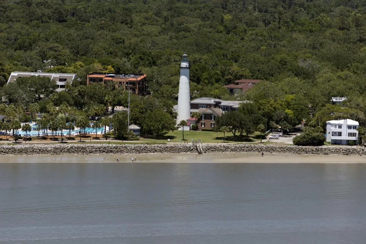
St. Simons Island, Georgia, takes its name from San Simón, a settlement from the Spanish era; the final s didn’t become official until 1943. Where the name came from is settled. What San Simón actually was, and how to spell the English version, took longer.
Why is it called St. Simons Island, Georgia?
The Coastal Georgia Historical Society, which runs the island’s lighthouse museum, puts it plainly in a 2020 article from its archives: St. Simons “derives from anglicizing the Spanish name of a 17th century settlement.” The New Georgia Encyclopedia names the place: San Simón. In English it became St. Simon, and some form of that name has stuck to the island ever since.
It wasn’t the first name here. The New Georgia Encyclopedia says by 1500 the Guale had a lasting settlement of some 200 people on the island, which they called Guadalquini. The society’s article lists other names that have been given to the region, among them Altamaha, Guale, Asao and Tolomato.
The Spanish didn’t stay. A Georgia Historical Society marker on the island says missionaries worked this coast from 1568, Jesuits first and then Franciscans, and that the missions were moved farther south in 1686. The encyclopedia says pirate raids in 1684 all but emptied the island’s missions and villages, and that Spain was gone from St. Simons by 1702. In 1736 James Oglethorpe founded Fort Frederica on the island; that year he also sailed south from here and named Amelia Island, in what is now Florida. On July 7, 1742, the National Park Service says, the British beat the Spanish at Gully Hole Creek and again at Bloody Marsh, which ended Spain’s last push into the colony.
St. Simons Island history: San Simón, a village or a mission
This is where the accounts split.
The New Georgia Encyclopedia describes two Spanish missions on the island in the 1600s, San Buenaventura de Guadalquini at the south tip and Santo Domingo de Asao at the north tip. San Simón isn’t one of them. Inland, the encyclopedia says, were “the pagan refugee villages of San Simón, the island’s namesake, and Ocotonico.” In that telling, San Simón was a village of people who hadn’t converted.
A 2002 newsletter from the Historic Preservation Division of Georgia’s Department of Natural Resources tells it another way. It says Creek Indians named their village on the island Asao, and that “By the 1500s, Spanish explorers had established three missions on Asao, and one of these missions was named San Simon.”
So one source has a village and the other a mission, nor do they agree on the century: the encyclopedia and the historical society point to the 1600s, the newsletter to the 1500s. The encyclopedia and the historical society both tie the island’s name to San Simón; the newsletter names the mission without saying so outright. None of them says which Simon was meant.
For most of its English history the island didn’t have a fixed spelling. The historical society’s article lists the versions on maps from 1737 to 1925: Great St. Simon’s Isle, St. Simon’s Island, St. Simon Island, St. Simons Island and even St. Symons Island.
The federal government tried to settle it. In 1891, the society says, the U.S. Board on Geographic Names declared the island Saint Simon Island, no s. By the 1930s it was clear that people living there said “Simons,” so the board met on it again in 1938. Its report included a statement from Mrs. Edwin Fendig, president of the Cassina Garden Club: “Aside from the fact that it has always been known as St. Simons, the present residents and property owners still prefer that name.” She added that “the name of a place is most vital to the people who live in that place.” The board left the s off anyway.
Five years later, in 1943, it reversed itself. Saint Simons Island has been the official form since then, though “St.” is the usual short form. The same board had dropped the h from Pittsburgh under its 1890 rule for names ending in “burgh,” and that city’s h wasn’t back for good until the board’s report of 1921.
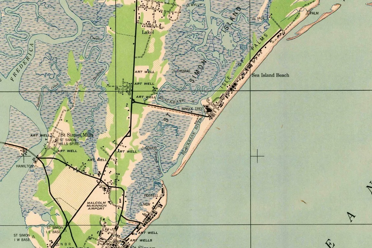
St. Simons Island on the 1945 map
Our crop is from a 15-minute sheet at 1:62,500, the Brunswick quadrangle, labeled “First Edition (AMS 1), 1945.” It was an Army Map Service job done for the Corps of Engineers, drawn from 1942 aerial photographs, with relief from the engineers’ Brunswick survey of 1912. Jekyll Island, the next island south, sits on the same sheet.
The sheet was printed two years after the board’s reversal, and it still spells the name without the s. “St Simon Island” is lettered in big spaced type across the marsh, and the crop also shows St Simon Mills, Hamilton, the Malcolm McKinnon Airport, the Frederica River at the edge, and a town labeled St Simon at the bottom. Toward the ocean are the Blackbank River, Isle of Palms and Sea Island Beach.
Quick answers
Who is St. Simons Island, Georgia, named after?
The island is named for San Simón, a Spanish-era settlement. Sources differ on whether it was a refugee village or a mission, and they don’t say which Simon it honored.
Why does St. Simons Island, Georgia, have an s?
Because the people living there used it. The U.S. Board on Geographic Names ruled for Saint Simon in 1891 and again in 1938, then switched to Saint Simons in 1943.
Is it Saint Simons or St. Simons Island, Georgia?
Both. Saint Simons Island is the official form since 1943, and St. Simons is the everyday way to write it.
Key dates
- 1568Jesuit missionaries, later followed by Franciscans, begin their missions on this coast, a state historical marker says.
- 1684Pirate raids all but empty the island's missions and villages, the New Georgia Encyclopedia reports.
- 1702Spain has fully pulled back from St. Simons, the encyclopedia says.
- 1736James Oglethorpe founds Fort Frederica on the island's west side.
- 1742July 7: the British beat the Spanish at Gully Hole Creek and then at Bloody Marsh, ending the invasion.
- 1891The U.S. Board on Geographic Names rules that the island is Saint Simon Island, with no final s.
- 1938The board takes up the s again, hears from the Cassina Garden Club's president, and still leaves it off.
- 1943The board reverses itself, and the official name becomes Saint Simons Island.
- 1945An Army map of the Brunswick area still letters the island St Simon.
- 2020The census counts 14,982 people living on the island.
Things to do in St. Simons Island, Georgia
St. Simons Lighthouse Museum
A museum of coastal Georgia history in the lighthouse keeper's dwelling, with exhibits on lighthouse technology and upstairs rooms set in 1907, when the keeper's family lived there without electricity or indoor plumbing.
World War II Home Front Museum
Housed in the island's 1936 Coast Guard station, whose crew rescued survivors on April 8, 1942, after a German U-boat torpedoed two American ships 13 miles (21 km) offshore.
Fort Frederica National Monument
The archeological remains of the British town and fort James Oglethorpe founded in 1736, reached from the visitor center by a walk of about a quarter mile (0.4 km) along Broad Street.
Bloody Marsh
The marsh where, on July 7, 1742, the British turned back the Spanish for the second time that day, after Gully Hole Creek, ending Spain's claims to Georgia. It has a scenic view and interpretive exhibits.
Cannon's Point Preserve
A preserve of more than 700 acres (283 ha) owned by the St. Simons Land Trust, with some of the island's last intact maritime forest, more than six miles (10 km) of shoreline, shell middens from 2500 BCE and the ruins of John Couper's plantation house.
Getting there
Open St. Simons Island in Google Maps
Opens in a new tab. The pin is the center of St. Simons Island in the USGS place-name record.
The closest airports, Amtrak stations and intercity bus stops, measured in a straight line from the center of St. Simons Island.
Airports
- Brunswick Golden Isles (BQK) 7 mi 11 km
- Jacksonville International (JAX) 54 mi 86 km
Amtrak trains
- Jesup station (JSP) 41 mi 66 km
- Savannah station (SAV) 61 mi 98 km
Intercity buses
- FlixBus Brunswick Perry Ln Rd/Venture Dr 9 mi 14 km
- Greyhound Kingsland Hospitality Ave 34 mi 55 km
Distances are as the crow flies, not by road. We don't list schedules or fares because they change; check with the airline, Amtrak or the bus company before you go. Official data (FAA commercial service airports (2025), FAA airport locations, Amtrak stations and Intercity Bus Atlas) from the FAA and the U.S. Bureau of Transportation Statistics, checked Nov 21, 2026.
Sponsored
Staying in St. Simons Island?
Compare hotels in St. Simons Island, Georgia, on Expedia.
See hotels in St. Simons IslandWe may earn a commission if you buy through this link. It never changes what we write. Read our affiliate disclosure
Historical Sources & References
- Mary Koon, “St. Simons Island,” New Georgia Encyclopedia. Guadalquini, the two missions, “the pagan refugee villages of San Simón, the island’s namesake, and Ocotonico,” the raids of 1684, Spain gone by 1702, and the 2020 census.
- Georgia Historic Preservation Division, Reflections (September 2002). Asao and “one of these missions was named San Simon.”
- Coastal Georgia Historical Society, “What’s in a Name? Adding an ‘s’ to St. Simon” (2020). The anglicized Spanish name, the map spellings of 1737-1925, the board’s rulings of 1891, 1938 and 1943, and Mrs. Fendig’s statement.
- Georgia Historical Society, “Old Spanish Garden”. Missions from 1568, moved south in 1686.
- Coastal Georgia Historical Society, St. Simons Lighthouse Museum and World War II Home Front Museum; National Park Service, Fort Frederica and Bloody Marsh; St. Simons Land Trust, Cannon’s Point Preserve. Fort Frederica’s founding, the battle of 1742 and the details in the things-to-do list.
- U.S. Geological Survey, GNIS feature 356512. The island’s federal record.
- Brunswick quadrangle, Army Map Service, First Edition (AMS 1), 1945. The sheet the map at the top was cropped from.
Spot something wrong, or know more? Tell us here. You can also email us or use our contact page. Corrections are noted here with their date, never made silently.