Mesilla, New Mexico: A Little Table on the Rio Grande
Mesilla is a Spanish word that Henry Gannett, compiling name origins for the Geological Survey, rendered in 1905 as "little table-land." The National Park Service says settlers who wanted to stay in Mexico after 1848 crossed the Rio Grande and "settled on a small rise in the river valley," and the settlement became known as Mesilla, or "little table."
Mesilla, New Mexico, has a Spanish name for a little tableland, given to a settlement on a small rise in the Rio Grande valley that was Mexican in 1848. The people who built it crossed the river on purpose, to stay in Mexico. Within six years, the border moved to them.
A little table, in three translations
The word itself is the part everyone agrees on. The oldest of the three versions is Henry Gannett’s, from 1905: “A Spanish word meaning ‘little table-land.’” The same entry covers a Mesilla in Butte County, California.
The National Park Service’s management plan for the El Camino Real de Tierra Adentro National Historic Trail ties the word to the ground. It says the settlers “settled on a small rise in the river valley,” and that “the settlement, known as Mesilla (little table), included about half the population of Doña Ana.” The revised 1962 edition of the WPA guide to New Mexico, first published in 1940, uses a third version, “Mesilla (little tableland),” for the land grant of 1853.
So you get “little table-land,” “little table” and “little tableland,” depending on the source. They’re all saying the same thing. If “tableland” rings a bell, Mesa, Arizona, was named for the tableland its founders settled in 1878.
Crossing the river to stay in Mexico
The Park Service dates Mesilla’s founding to 1848, the year of the Treaty of Guadalupe Hidalgo. According to the management plan, the treaty left the area west of the Rio Grande in Mexico, while Las Cruces and Doña Ana, on the east bank, were in American territory. As Anglo-Americans arrived to claim land, many Mexican residents moved away. “Those who preferred to remain in the area but on Mexican soil crossed the river” and founded Mesilla.
In 1853 the Mexican government issued the Mesilla Civil Colony Land Grant. The Park Service’s article on the town says one of its pioneering settlers, Valentin Maese, put up a two-room home just east of what would become the plaza in 1849. His jacal of vertical logs and adobe plaster stood with others around the plaza’s edge “as a means of community defense.”
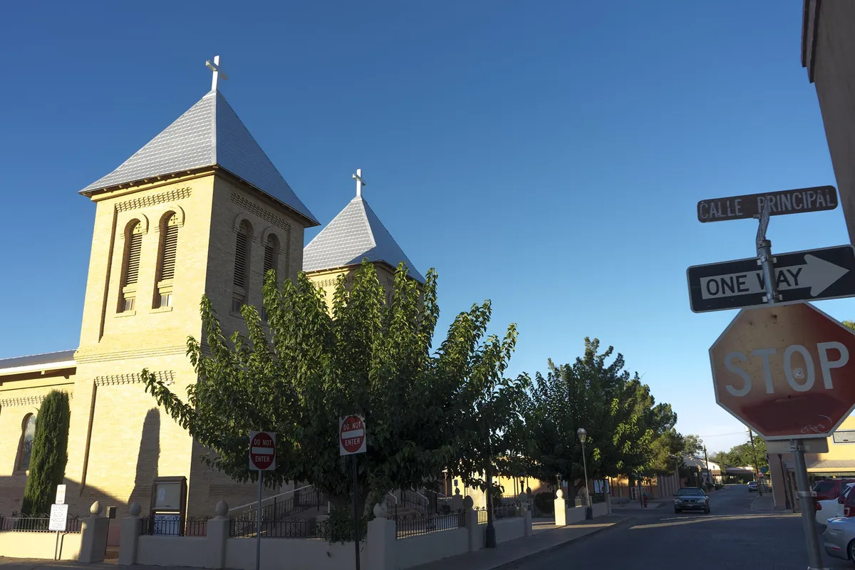
The plaza’s church changed with the town. A simple church went up on the south side when the village was established, the Park Service says, and by 1857 an adobe church stood at the north end. In 1906 the yellow-brick church of San Albino replaced it, and in 2008 it was designated one of two basilicas in New Mexico.
The day the flag changed
The border didn’t stay put. The Gadsden Purchase of 1854 bought a strip of land south of New Mexico and Arizona from Mexico, and Mesilla’s residents found themselves in the United States. On November 16, 1854, the management plan says, “the treaty was symbolically formalized in the plaza at Mesilla.” The Mexican flag came down and the American flag went up, with officials and soldiers from both governments on hand.
The purchase carried the name of James Gadsden, the same man honored by Gadsden, Alabama. Mesilla became a stop on Butterfield’s Overland Mail in 1857, according to the WPA guide, or in 1858, according to the Park Service’s management plan, and in July 1861 Confederate Lt. Col. John Baylor made it the capital of a Confederate Territory of Arizona. The town’s own history says Billy the Kid was tried and sentenced there in 1881. That same year, the railroad was routed through neighboring Las Cruces instead.
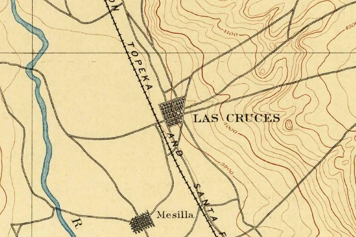
Mesilla on the 1891 map
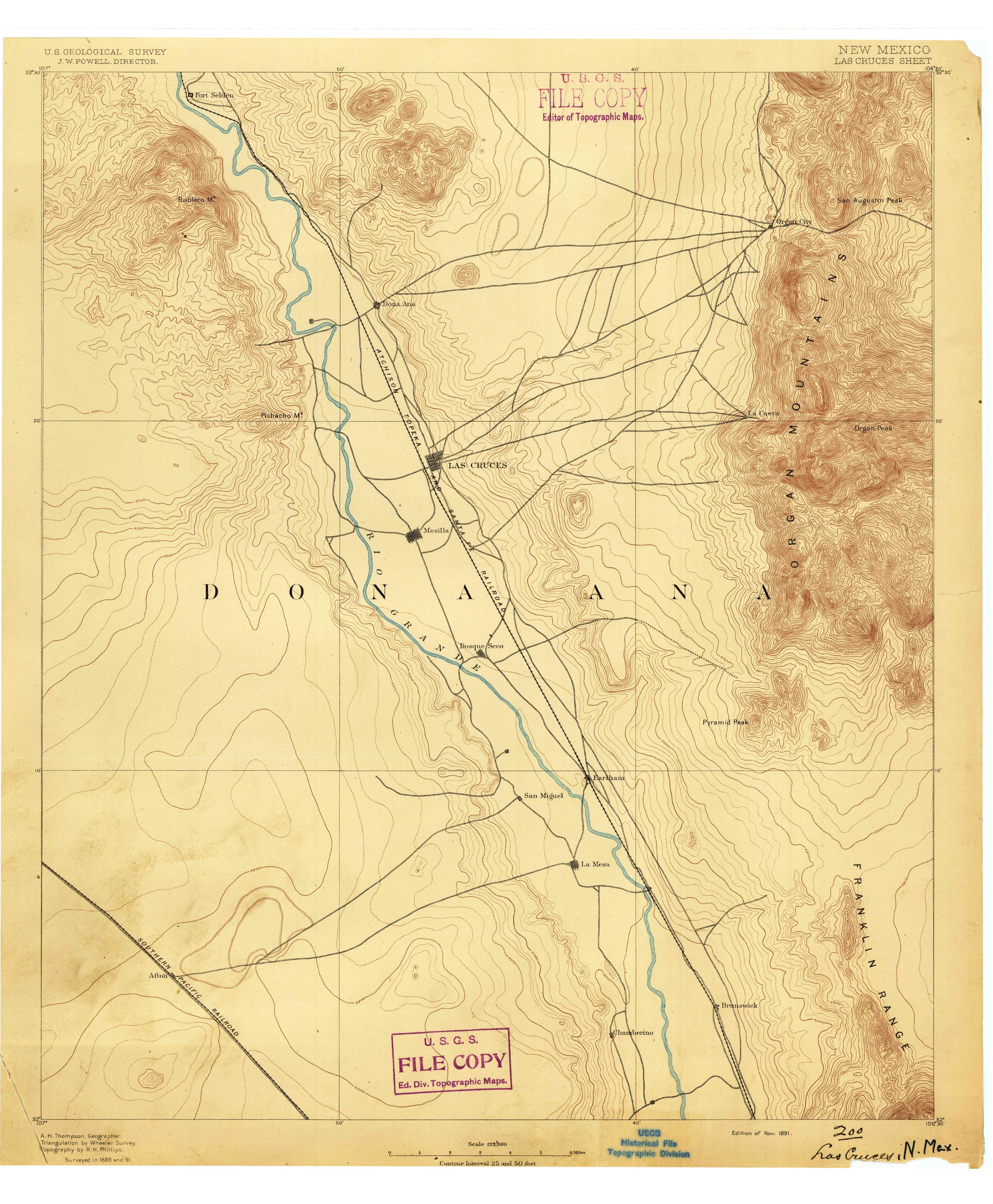
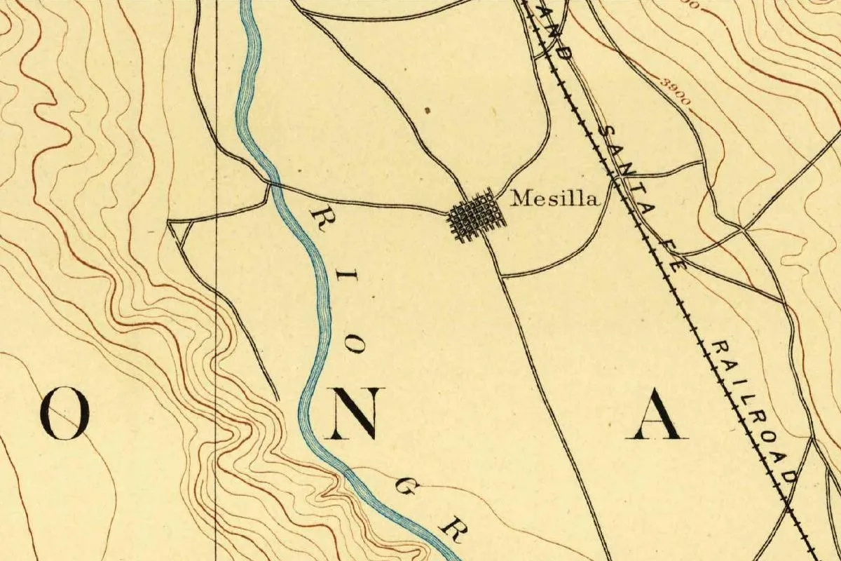
The map at the top of this page is the Geological Survey’s Las Cruces sheet, surveyed in 1889 and 1891 and issued in November 1891. It shows you Mesilla as a small, tight grid of streets where several roads meet. The Santa Fe railroad runs past to the east. Las Cruces, which the Park Service puts two miles (3 km) to the northeast, is on the same sheet, labeled with its own grid just north of this detail.
The blue line of the Rio Grande winds along the west side of the town on this sheet. The founders, by the Park Service’s account, “crossed the river” from the American side in 1848. The same plan notes, in its entry on the nearby Bracito site, that “in 1864 floodwater caused the Río Grande to break away from its old channel and change course substantially.” It doesn’t say whether that flood moved the river at Mesilla itself. The 1962 WPA guide puts Old Mesilla at an altitude of 3,857 feet (1,176 m).
Quick answers
What does Mesilla mean?
“Little table-land,” in Gannett’s reading of the Spanish word. The National Park Service renders it “little table,” and the WPA guide “little tableland.”
Why is it called Mesilla?
For the ground it was built on, as the National Park Service tells it. The Park Service says the settlers “settled on a small rise in the river valley,” and the settlement became known as Mesilla.
When did Mesilla become part of the United States?
In 1854, with the Gadsden Purchase. The flag ceremony in the plaza took place on November 16, 1854.
Key dates
- 1848Mesilla is founded west of the Rio Grande, on land the Treaty of Guadalupe Hidalgo left in Mexico, according to the National Park Service.
- 1853The Mexican government issues the Mesilla Civil Colony Land Grant.
- 1854On November 16, the Mexican flag is lowered and the U.S. flag raised in Mesilla's plaza to mark the Gadsden Purchase.
- 1881Billy the Kid is tried in Mesilla, and the railroad is routed through Las Cruces instead, according to the town.
- 1906The yellow-brick church of San Albino replaces the adobe church on the plaza.
Things to do in Mesilla, New Mexico
Mesilla Plaza
The plaza that the National Park Service calls the social, spiritual and economic center of town since its founding in 1848, now paved and landscaped, with a replica 1930s-era bandstand and historic commercial buildings around its edges.
Basilica of San Albino
The yellow-brick church on the north end of the plaza, rebuilt in its present form in 1906 with what the Park Service describes as 'square belfries with pyramid towers' and arched stained-glass windows, and named a basilica on November 1, 2008.
Mesilla Mercado
The market held on the historic plaza, which the town calls one of America's oldest markets, dating to 1857, with handcrafted jewelry, original artwork and locally grown produce.
Double Eagle Restaurant
One of the oldest buildings on the plaza, a Territorial-style building with a central courtyard on the site of the two-room home Valentin Maese built for his family in 1849, according to the National Park Service.
Leonart-Maurin Store
A building on the southwest corner of the plaza that French émigré Augustin Maurin built between 1860 and 1863 of hand-fired brick from a local kiln, which the Park Service calls one of the earliest local-brick buildings in New Mexico.
Getting there
Open Mesilla in Google Maps
Opens in a new tab. The pin is the center of Mesilla in the USGS place-name record.
The closest airports, Amtrak stations and intercity bus stops, measured in a straight line from the center of Mesilla.
Airports
- El Paso International (ELP) 41 mi 65 km
Amtrak trains
- El Paso station (ELP) 40 mi 64 km
- Deming station (DEM) 56 mi 90 km
Intercity buses
- Limousine Express Las Cruces 2 mi 4 km
- Greyhound Las Cruces NM (LCR) 3 mi 4 km
- Limousine de Mexico El Paso (Limo Express) 40 mi 65 km
Distances are as the crow flies, not by road. We don't list schedules or fares because they change; check with the airline, Amtrak or the bus company before you go. Official data (FAA commercial service airports (2025), FAA airport locations, Amtrak stations and Intercity Bus Atlas) from the FAA and the U.S. Bureau of Transportation Statistics, checked Nov 17, 2026.
Sponsored
Staying in Mesilla?
Compare hotels in Mesilla, New Mexico, on Expedia.
See hotels in MesillaWe may earn a commission if you buy through this link. It never changes what we write. Read our affiliate disclosure
Historical Sources & References
- Henry Gannett, The Origin of Certain Place Names in the United States (1905), p. 206. “A Spanish word meaning ‘little table-land.’”
- National Park Service, El Camino Real de Tierra Adentro Comprehensive Management Plan, Appendix E, pp. 187-188. The crossing of the river, “Mesilla (little table),” the land grant of 1853, the ceremony of November 16, 1854, and the flood of 1864 at Bracito.
- New Mexico: A Guide to the Colorful State, revised edition (1962), p. 260. “Mesilla (little tableland) Colony Grant,” the altitude of 3,857 feet (1,176 m), the Overland Mail of 1857 and Baylor in 1861. Checked against the page image.
- National Park Service, “Mesilla Plaza and Mesilla Historic District”. The founding in 1848, Valentin Maese’s house of 1849, San Albino in 1906 and 2008, and the two miles (3 km) to Las Cruces.
- Town of Mesilla, “History”; “Tours and Museums”; “Mercado and Farmers Market”. The flag raising of 1854, Baylor, Billy the Kid and the railroad in 1881, the basilica, and the market.
- GNIS feature 920645 (U.S. Geological Survey). Mesilla’s listing as a populated place in Doña Ana County, with its coordinates.
- U.S. Geological Survey, Las Cruces sheet (November 1891). The 1:125,000 sheet the map at the top was cropped from.
Sponsored
Put this 1891 map on your wall
The Geological Survey's 1891 Las Cruces sheet, which shows Mesilla on the Rio Grande, is in the public domain. Download the full-size scan for free, then have it printed on canvas with CanvasOnTheCheap.
Print a map on canvasDownload the full-size mapWe may earn a commission if you buy through this link. It never changes what we write. Read our affiliate disclosure
Spot something wrong, or know more? Tell us here. You can also email us or use our contact page. Corrections are noted here with their date, never made silently.