Punxsutawney, Pennsylvania: A Lenape Name for Sandflies
Punxsutawney comes from a Lenape (Delaware) name that the borough translates as 'town of the sandflies.' The Moravian missionary John Ettwein, camping there in 1772, wrote that the Indians called it 'the town of the ponkies,' after tiny biting gnats, and the historians A. Howry Espenshade and George P. Donehoo read the name the same way.
Long before the groundhog, Punxsutawney, Pennsylvania, was known for a much smaller pest: the borough says its Lenape name means “town of the sandflies.” If you’ve only heard the name on February 2, that may come as a surprise. The missionary who explained it in 1772 wasn’t thinking about the weather at all. He couldn’t even hold an evening service for the bugs.
A bad night in the swamp
In 1772 John Ettwein, a Moravian missionary, was leading a band of Christian Delaware Indians west from Wyalusing toward the Big Beaver River. A. Howry Espenshade, who tells the story in his 1925 book Pennsylvania Place Names, calls Ettwein’s journal “the best explanation of the name.” On July 19, 1772, Ettwein wrote that the camp couldn’t even hold a service, because the “ponkies” were so bad that the cattle crowded into the smoke of the fire to get away from them. Then he explained what the place was called:
“Hence the Indians call it ponsetunik, ‘the town of the ponkies.’ The word is equivalent to living dust and ashes, the vermin being so small as not to be seen, and their bite being as hot as sparks of fire or hot ashes.” (Espenshade, p. 191)
George P. Donehoo quotes the same entry in his 1928 history of Pennsylvania’s Indian villages and place names, with a different spelling: “Ponks-utenink, i.e., ‘the town of the Ponkis.’” He took it from an earlier writer, Hanna, not from the diary itself. So these are two printings of one witness, not two separate witnesses. Ettwein, at least, was writing on the spot.
Sandflies, gnats or punkies
Every source here agrees the name is about a tiny biting insect. They just disagree on what to call it. Espenshade says the name came from the “punkies,” or gnats, that annoyed the early settlers, and he points out that the word made it into English: the Standard Dictionary of his day defined a punky as “a species of minute, annoying gnats.” Donehoo calls the name “a corruption of Ponks-uteney, ‘gnat town,’” and cites the missionary John Heckewelder, who wrote that the place was full of gnats, or sand-flies.
Henry Gannett, who sorted out the origins of thousands of American names for the Geological Survey, gave it a single line in 1905: “An Indian word meaning ‘sand-fly place.’” The borough says the name is from the language of the Lenape people and means “town of the sandflies.” The National Weather Service’s Mount Holly office writes the Lenape original as “ponksad-uteney,” and SAH Archipedia’s architectural guide gives “Ponks-ad-u-te-ny” along with “town of ponkies,” which it glosses as “floating ashes.”
The hermit’s ashes
Ettwein had already tied the word to ashes, and he heard a story on the spot to explain why. As Espenshade quotes him, the Indians told of a hermit and sorcerer who had long terrified everyone around. When he was finally killed, his bones were burned, and the ashes were blown into the swamp, “where they became living things, and hence the ponkies.” Donehoo tells it from Heckewelder’s version: the chief who killed the magician burned his bones, and the ashes turned into “Ponksak,” sand-flies.
The ashes stuck to the place for a while. Espenshade writes that “The Moravians called the place Ash-town, and sometimes the early settlers spoke of it as Gnat-town.” Donehoo collects older spellings. In 1755 Marie LeRoy and Barbara Leininger, two young women taken captive below Shamokin, were marched through “Puncksetonay or Eschentown” on the way to Kittanning. In 1758 the envoy Christian Frederick Post passed “Ponchestanning (an Old town that lies on the same Creek).”
Was there ever a village?
Here the sources part ways, and it’s worth saying so. The National Weather Service says that in 1723 the Delaware Indians settled Punxsutawney, as a campsite halfway between the Allegheny and Susquehanna rivers. Donehoo wasn’t convinced. “While it is stated by most writers, Post included, that there was a village at this point, it is doubtful,” he wrote. Why would anyone live where the sand-flies were that bad? The Indians knew the place for its insects, he argued, “and no doubt these were the only occupants of the place.”
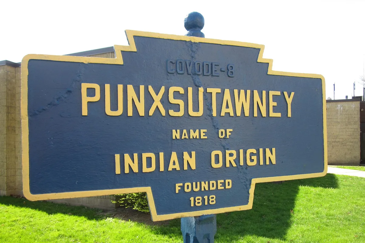
The town on today’s map came later. The borough says the Rev. David Barclay bought 327 acres in 1819, the original site of Punxsutawney, and that when the town site was recorded in 1821, in what was then Indiana County, Barclay and his son-in-law John W. Jenks set aside “a parcel of land for public use.” SAH Archipedia dates Barclay’s grid to about 1818, which matches the “Founded 1818” on the keystone marker in the photo below. The borough says Punxsutawney became a borough in 1850; SAH Archipedia says 1851.
Plenty of other places across the old Lenape homeland kept names from that language. Hoboken, New Jersey, may carry a Lenape word for a tobacco pipe, though that one is still argued over, and Muncie, Indiana, is named for the Munsee, a division of the Delaware people who had a town where the city now stands.
Then came the groundhog
The National Weather Service says that in 1886 Clymer H. Freas, city editor of the Punxsutawney Spirit, dubbed a group of local groundhog hunters the Punxsutawney Groundhog Club and proclaimed the local groundhog the one official forecaster. SAH Archipedia also counts the ceremony from 1886, while the borough dates the town’s fame to 1887, and the club itself says only that it formed in the 1880s. The borough adds that the 1993 movie Groundhog Day spread the tradition further, though SAH Archipedia notes that the movie was filmed in Woodstock, Illinois.
The borough puts Punxsutawney about 90 miles (145 km) northeast of Pittsburgh, on Mahoning Creek in Jefferson County. Espenshade’s 1925 book ranges over the whole of Pennsylvania, and Punxsutawney is one of the Indian names where he quotes a witness who was standing in the swamp.
Punxsutawney on the 1906 map
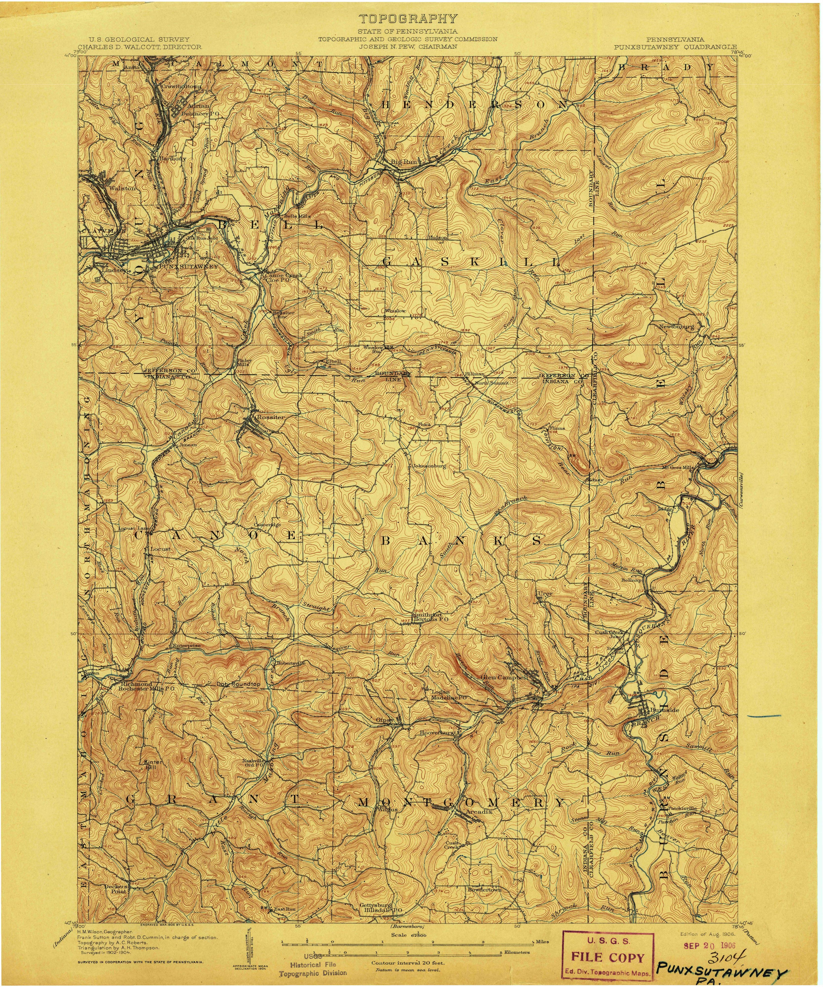
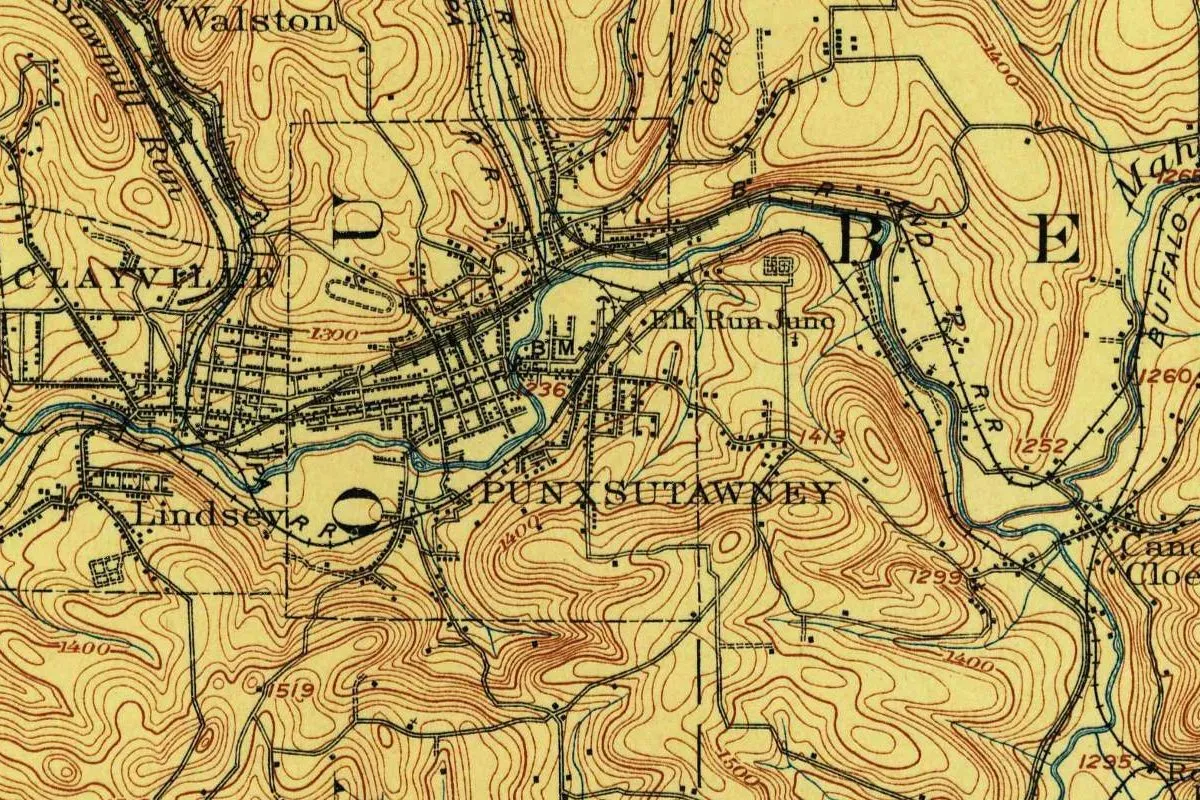
The map at the top comes from the Geological Survey’s Punxsutawney sheet, surveyed in 1902-1904 in cooperation with the State of Pennsylvania, engraved in March 1906 and issued as the edition of August 1906. The copy scanned here is that first edition, stamped into the Survey’s files in September 1906, with no later printing. The town sits in the northwest corner of the sheet. You’ll find “PUNXSUTAWNEY” printed below a tight grid of streets along a winding blue creek, a bench mark of 1,236 feet (377 m), Clayville and Lindsey to the west, Walston to the north and “Elk Run Junc” to the east, rail lines marked “R R,” and brown contour lines climbing to 1,413 and 1,519 feet (431 and 463 m) on the hills around it.
Quick answers
What does Punxsutawney mean?
The borough says the Lenape name means “town of the sandflies.” Henry Gannett (1905) gave “sand-fly place,” and the missionary John Ettwein wrote in 1772 that the Indians called it “the town of the ponkies,” after tiny biting gnats.
What language is Punxsutawney from?
From the language of the Lenape, or Delaware, people, according to the borough, the National Weather Service and SAH Archipedia.
What is a ponkie, or punky?
A tiny biting gnat. Espenshade quotes the Standard Dictionary: “a species of minute, annoying gnats.” Ettwein said they were so small you couldn’t see them and their bite felt like hot ashes.
When did Groundhog Day start in Punxsutawney?
The National Weather Service and SAH Archipedia say 1886; the borough dates the town’s fame to 1887. The Groundhog Club says it was formed in the 1880s.
Key dates
- 1755Captives Marie LeRoy and Barbara Leininger are taken through a place their narrative calls Puncksetonay or Eschentown.
- 1758Christian Frederick Post passes Ponchestanning, "an Old town," on his way back from the Ohio.
- 1772John Ettwein, leading Moravian converts west, writes on July 19 that the Indians call the swamp "the town of the ponkies."
- 1819The Rev. David Barclay buys 327 acres, the original site of Punxsutawney, the borough says.
- 1821The town site is recorded in Indiana County, with a parcel set aside for public use.
- 1850Punxsutawney becomes a borough, by the borough's own account; SAH Archipedia gives 1851.
- 1886Newspaper editor Clymer H. Freas names the Punxsutawney Groundhog Club, the National Weather Service says.
- 1906The Geological Survey issues its Punxsutawney sheet, surveyed in 1902-1904.
Things to do in Punxsutawney, Pennsylvania
Punxsutawney Weather Discovery Center
A center on North Findley Street that bills Punxsutawney as "The Weather Capital of the World" and sets out to teach the science and folklore of weather.
Lattimer House museum
The historical and genealogical society's museum complex, where the Lattimer House is open, with collections of quilts, clothing and decorative arts and service uniforms, and galleries on the area's photographers, painters and crafters.
Barclay Square Memorial Park
The town's central square, turned from "wasteland" into a park in 1902, with two cannons placed in 1910 and a native-stone bandstand dedicated in 1932 to veterans of all wars.
Mahoning Shadow Trail
A 15-mile (24 km) trail on the old Pennsylvania & North Western rail line, opened in 2002 and 2004, that follows Mahoning Creek into town and passes the remains of old coke ovens.
Phantastic Phils
More than 40 six-foot fiberglass groundhog statues, each painted by local artists, set around town since the first one, Phillage, went up in 2004. The borough offers a map for a walking tour.
Getting there
Open Punxsutawney in Google Maps
Opens in a new tab. The pin is the center of Punxsutawney in the USGS place-name record.
The closest airports, Amtrak stations and intercity bus stops, measured in a straight line from the center of Punxsutawney.
Airports
- John Murtha Johnstown/Cambria County (JST) 44 mi 71 km
- Arnold Palmer Regional (LBE) Latrobe 52 mi 83 km
- Pittsburgh International (PIT) 73 mi 118 km
Amtrak trains
- Altoona station (ALT) 42 mi 68 km
- Johnstown station (JST) 43 mi 68 km
Intercity buses
- Fullington Trailways Punxsutawney under 1 mi 0.4 km
- Greyhound Ebensburg PA (EBN) 34 mi 55 km
- OurBus Slippery Rock, PA (Maltby Avenue, Near Miller Auditorium Old main Loop Slippery Rock, PA 16057, USA) 57 mi 92 km
Distances are as the crow flies, not by road. We don't list schedules or fares because they change; check with the airline, Amtrak or the bus company before you go. Official data (FAA commercial service airports (2025), FAA airport locations, Amtrak stations and Intercity Bus Atlas) from the FAA and the U.S. Bureau of Transportation Statistics, checked Nov 18, 2026.
Sponsored
Staying in Punxsutawney?
Compare hotels in Punxsutawney, Pennsylvania, on Expedia.
See hotels in PunxsutawneyWe may earn a commission if you buy through this link. It never changes what we write. Read our affiliate disclosure
Historical Sources & References
- A. Howry Espenshade, Pennsylvania Place Names (1925), pp. 191-192. The punkies, John Ettwein’s journal entry of July 19, 1772, the hermit’s ashes, Ash-town and Gnat-town, and the dictionary definition of punky. Checked against the page image.
- George P. Donehoo, A History of the Indian Villages and Place Names in Pennsylvania (1928), pp. 163-164. “Ponks-uteney, ‘gnat town,’” Heckewelder’s account, Ettwein’s entry as quoted by Hanna, Post’s Ponchestanning of 1758, LeRoy’s Puncksetonay or Eschentown of 1755, and Donehoo’s doubt that there was ever a village.
- Henry Gannett, The Origin of Certain Place Names in the United States (1905), p. 255. “An Indian word meaning ‘sand-fly place.’”
- Borough of Punxsutawney, “About Punxsutawney”; Barclay Square Memorial Park. The Lenape name and “town of the sandflies,” the borough of 1850, the fame of 1887, the distance from Pittsburgh, and Barclay’s 327 acres of 1819 and the town site of 1821.
- National Weather Service, Mount Holly, “Groundhog Day History”. “Ponksad-uteney,” the Delaware settlement of 1723, and Clymer H. Freas in 1886.
- Lu Donnelly et al., “Punxsutawney and Vicinity,” SAH Archipedia. Barclay’s grid of about 1818, the borough of 1851, “town of ponkies” and “Ponks-ad-u-te-ny,” the ceremony since 1886, and Woodstock, Illinois.
- Punxsutawney Groundhog Club, “About”. The club formed in the 1880s.
- Weather Discovery Center; historical society exhibits; Mahoning Shadow Trail; Phantastic Phils. The details in the things-to-do list.
- U.S. Geological Survey, GNIS feature 1214004. The official name, Jefferson County and coordinates of the borough, as the government’s names database carries them.
- Punxsutawney sheet, surveyed 1902-1904, edition of August 1906. The sheet the map at the top was cropped from, with topography by A. C. Roberts and H. M. Wilson as geographer.
Sponsored
Put this 1906 map on your wall
The 1906 Punxsutawney quadrangle, surveyed in 1902-1904 by the Geological Survey with the State of Pennsylvania, is in the public domain. Download the full-size scan for free, then have it printed on canvas with CanvasOnTheCheap.
Print a map on canvasDownload the full-size mapWe may earn a commission if you buy through this link. It never changes what we write. Read our affiliate disclosure
Spot something wrong, or know more? Tell us here. You can also email us or use our contact page. Corrections are noted here with their date, never made silently.