Waxahachie, Texas: What Does the Name Mean?
Waxahachie took its name from Waxahachie Creek in 1850. The Handbook of Texas says the word means "cow" or "buffalo," Ellis County calls it a Tejas word for "buffalo creek," and the city's design guidelines mention an Alabama-Coushatta term for "calf's tail." The Ellis County Museum says the cow story has never been proved.
Waxahachie, Texas, is named for the creek that runs past it, but nobody has pinned down which language the word comes from or what it means. Cow, buffalo, calf’s tail and a name carried over from South Carolina have all been offered, and you’ll find each one below with the source that gives it.
The creek first
The city’s own history starts with the stream. The Handbook of Texas entry on Waxahachie Creek says it rises near Midlothian and runs for 23½ miles (38 km), passing along the south side of the city on the way to Chambers Creek. The city’s Residential Design Guidelines of 2021, which reprint a 2019 historic survey by HHM & Associates, say “the town was dubbed Waxahachie after the creek that ran through the south side of the developing town.”
That happened in 1850. In August 1850, Margaret L. Felty writes in the Handbook, Waxahachie became the seat of the new Ellis County, built on land that Emory W. Rogers, one of the first settlers, gave for it. Ellis County’s courthouse page puts the gift at 62 acres (25 ha) along the creek. The first courthouse went up that year.
Cow, buffalo or calf’s tail
The meaning is where things come apart. Felty’s entry says “the name comes from an Indian word meaning ‘cow’ or ‘buffalo’,” without naming the language. Ellis County is more specific: “The voters were told by the state legislature to name the county seat, ‘Waxahachie’ a Tejas Native American word for ‘buffalo creek.’” Henry Gannett’s 1905 note for the Geological Survey tied it to livestock, saying the town was “so named because of the large number of cattle in the vicinity” and that the word meant “cow town” or “cow creek.”
The city’s design guidelines hedge. “Existing historical records do not reflect which specific Native American tribe named the creek,” they say, and while many people believe it means “buffalo creek” or “cow creek,” “others state it specifically means ‘buffalo droppings.’” They add one more: “Some believe that it comes from the Alabama‐Coushatta people’s term waakasi hachi, meaning ‘calf’s tail.’”
The Ellis County Museum is the most skeptical. As Nataly Keomoungkhoun reported in The Dallas Morning News in 2021, a museum excerpt says the name was known for years as a Native word for “cow creek” or “cow chips,” but that no reliable source has ever backed that up.
A South Carolina theory
The same 2021 story carries a different idea, from John Hamilton, a member of the museum’s board. As the paper reported his research, he concluded that the town was named by Gen. Edward H. Tarrant. Tarrant was born in Bamberg, South Carolina, “a town on the Coosawhachie and Salkahachie rivers,” and Hamilton found that “hachie” or “hatchie” was commonly used for rivers across the Carolinas, Tennessee, Alabama and Mississippi. He thinks Tarrant joined that word to the name of the Waxhaw, a tribe from South Carolina. Even the paper notes that why Tarrant would do that “remains unknown.”
The “hatchie” ending turns up as far away as Calera, Alabama, which the Encyclopedia of Alabama says started out as Buxahatchie. And Waxahachie isn’t the only town whose “buffalo” is up for debate; Buffalo, New York, has bison, basswood and a mistranslation among its candidates.
The paper also talked to two people about the area’s Native history. Scott Langston of Texas Christian University said the Waxahachie area falls between lands where the Wichita and Caddo lived, and the museum notes that the Tonkawa came through in the 1800s. Diana Parton, a Caddo descendant, wasn’t familiar with the Waxhaw. She said Tarrant might have seen similarities between them and the peoples who lived there at the time, or “maybe he was honoring them.”
The Gingerbread City
Whatever the word means, the town grew around the creek. The Handbook says the town was incorporated April 28, 1871, and its short railroad, the Waxahachie Tap, began running to Garrett in September 1879. The Texas Historical Commission says the cornerstone of James Riely Gordon’s courthouse went down on July 4, 1895, and that the building was finished in 1897. The county’s courthouse page adds that no other state has as many historic courthouses as Texas, which counts 225. The Chautauqua Auditorium followed in 1902.
Felty says Waxahachie is called the Gingerbread City for its houses and buildings from before 1900, and that four movies were filmed there in the 1980s.
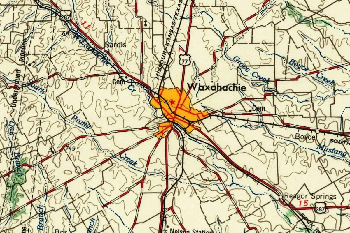
Waxahachie on the 1958 map
The map at the top of this page is the Dallas sheet, NI 14-12, at 1:250,000. Its margin says it was “Prepared by the Army Map Service (AJEE), Corps of Engineers, U. S. Army” and “Compiled in 1954 by photogrammetric methods,” from aerial photography of 1952-1953. The printer’s line reads “PRINTED BY ARMY MAP SERVICE, CORPS OF ENGINEERS, 1-58,” so this copy was printed in January 1958, and the Survey’s file copy carries a February 4, 1958, stamp noting it was printed by the Army Map Service for the Geological Survey.
In the detail, you can see Waxahachie as an orange patch with a red star, and the creek that gave it its name labeled Waxahachie Cr on the northwest side, near Sardis. South Prong Creek, Grove Creek and Boyce Creek are close by, along with Ike, Boyce, Reagor Springs and Nelson Station. The Missouri-Kansas-Texas line runs through town, and shields for routes 287 and 77 mark the highways on either side of it.
Quick answers
What does Waxahachie mean?
The sources don’t agree. The Handbook of Texas says “cow” or “buffalo,” Ellis County says a Tejas word for “buffalo creek,” Gannett said “cow town” or “cow creek,” and the city’s guidelines add “calf’s tail” in Alabama-Coushatta.
Is Waxahachie named after a creek?
Yes, by the city’s design guidelines, which say the town “was dubbed Waxahachie after the creek.” The Handbook of Texas notes only that the creek shares the name.
How do you pronounce Waxahachie?
The Dallas Morning News gives it as walks-uh-HATCH-ee.
Key dates
- 1850Waxahachie is laid out in August as the seat of the new Ellis County, on land given by Emory W. Rogers; the first courthouse goes up.
- 1871The town is incorporated on April 28.
- 1879The Waxahachie Tap Railroad to Garrett goes into operation in September.
- 1895The cornerstone of James Riely Gordon's courthouse is laid on July 4.
- 1897The courthouse, the fourth on the square, is finished.
- 1902The octagonal Chautauqua Auditorium is built for the town's yearly assemblies.
- 1905Henry Gannett's note for the Geological Survey gives Waxahachie as an Indian word for "cow town" or "cow creek."
Things to do in Waxahachie, Texas
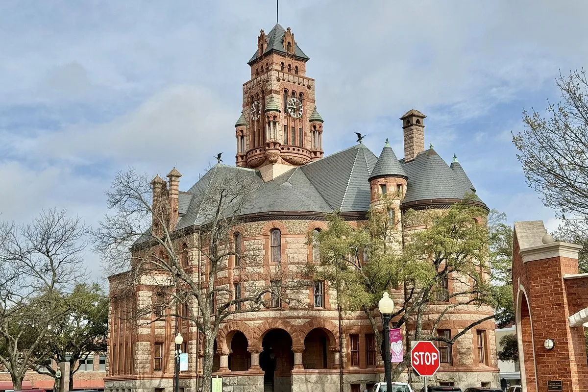
Ellis County Courthouse
James Riely Gordon's red sandstone and granite courthouse of 1897, the fourth on the square, with carved faces on its stonework and a clock tower; the county's page offers a walking guide around it.
Ellis County Museum
The county's history museum, in a building from 1889 that it calls the oldest in downtown Waxahachie, with displays on Ellis County and its people and an area for children.
Chautauqua Auditorium
An eight-sided open-air hall from 1902, restored in 1975, in the 23-acre (9.3 ha) Getzendaner Memorial Park; the visitors bureau says it's the only original Chautauqua building known to survive in Texas.
Nicholas P. Sims Library
The public library paid for by Nicholas P. Sims's estate and built in 1903-1904 on land from W. H. Getzendaner, the town's first mayor; the library calls it "one of the first public libraries built in Texas."
Getting there
Open Waxahachie in Google Maps
Opens in a new tab. The pin is the center of Waxahachie in the USGS place-name record.
The closest airports, Amtrak stations and intercity bus stops, measured in a straight line from the center of Waxahachie.
Airports
- Dallas Love Field (DAL) 32 mi 51 km
- Dallas-Fort Worth International (DFW) 37 mi 59 km
Amtrak trains
- Dallas station (DAL) 27 mi 43 km
- Cleburne station (CBR) 31 mi 50 km
Intercity buses
- FlixBus Downtown Dallas / Deep Ellum 28 mi 45 km
- Greyhound Arlington Andrews Street 29 mi 47 km
Distances are as the crow flies, not by road. We don't list schedules or fares because they change; check with the airline, Amtrak or the bus company before you go. Official data (FAA commercial service airports (2025), FAA airport locations, Amtrak stations and Intercity Bus Atlas) from the FAA and the U.S. Bureau of Transportation Statistics, checked Nov 18, 2026.
Sponsored
Staying in Waxahachie?
Compare hotels in Waxahachie, Texas, on Expedia.
See hotels in WaxahachieWe may earn a commission if you buy through this link. It never changes what we write. Read our affiliate disclosure
Historical Sources & References
- Margaret L. Felty, “Waxahachie, TX,” Handbook of Texas Online. The “cow” or “buffalo” meaning, the county seat of 1850 and Emory W. Rogers, incorporation in 1871, the Waxahachie Tap, the courthouse, the Chautauqua and the Gingerbread City.
- “Waxahachie Creek,” Handbook of Texas Online. The creek’s source, length and course.
- City of Waxahachie, Residential Design Guidelines (2021), p. 9. The town named for the creek, the unknown tribe, the buffalo and cow readings, and waakasi hachi.
- Ellis County, “Our Historic Court House”. The Tejas word for “buffalo creek,” the 62 acres and the courthouse.
- Nataly Keomoungkhoun, “Curious Texas,” The Dallas Morning News (2021). The pronunciation, the museum’s doubts about “cow creek,” John Hamilton’s Tarrant theory, and the comments of Scott Langston and Diana Parton.
- Henry Gannett, The Origin of Certain Place Names in the United States (1905), p. 318. The cattle and “cow town” or “cow creek.”
- Texas Historical Commission, Ellis County Courthouse. The cornerstone of 1895 and the completion in 1897.
- Ellis County Museum, Chautauqua Auditorium and Nicholas P. Sims Library. The places listed above.
- Waxahachie’s GNIS entry, feature 1349560 (U.S. Geological Survey). The city’s listing as a populated place in Ellis County, with its coordinates.
- Army Map Service, Dallas sheet NI 14-12 (compiled 1954, printed January 1958). The 1:250,000 sheet the map at the top was cropped from.
Spot something wrong, or know more? Tell us here. You can also email us or use our contact page. Corrections are noted here with their date, never made silently.