Thurmond, West Virginia: A Surveyor Paid in Land
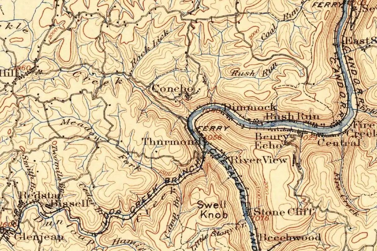
In 1873 William Dabney Thurmond took 73 acres of New River Gorge bottomland as pay for a survey, and Thurmond, West Virginia, still carries his name. The Chesapeake and Ohio opened its main line through the gorge that same year, and that’s what made the land worth having.
A surveyor’s fee
The National Park Service tells it simply: “Thurmond is named for William Dabney Thurmond, who received the 73-acre site in 1873 as payment for a surveying job.” e-WV, the West Virginia Humanities Council’s encyclopedia, adds that he’d been commissioned to survey land on the north side of the New River, took the 73 acres as his pay and built the town there over the following years. The state’s Blue Book, in its list of municipalities, describes the town as “named for Captain W. D. Thurmond, who owned the land upon which the town is located.”
He was a captain because of the Civil War. The encyclopedia says he served with Thurmond’s Rangers, irregular Confederate troops led by his brother Philip, and, according to his family, stayed an “unreconstructed Rebel” for the rest of his long life. He was also a strict Baptist, and while he owned almost all of the town, he didn’t allow rowdy living inside its limits. The saloons that gave Thurmond its reputation sat outside them, mostly across the river.
The railroad for a street
What made the land worth anything was the C&O. The Park Service says a freight station went up ten years after the main line opened, then a bridge to the coal mines across the river, and the land next to the town became an assembly yard for the gorge’s rail traffic. The town had to climb the slope behind. It had no streets or cars until 1921.
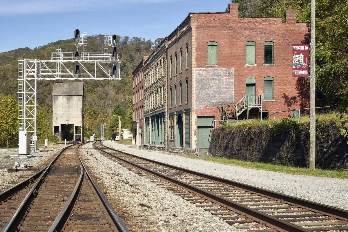
J. T. Peters and H. B. Carden, writing about Fayette County in 1926, describe the business district “crouched in the narrow confines between the river’s bank and the mountain, with the Chesapeake & Ohio railroad for a street.” Then they brag a little:
“…yet when it comes to producing revenue, the Chesapeake & Ohio railroad company would not exchange Thurmond for three or four Cincinnatis, half a dozen Richmonds, or a score of Charlestons.”
In one boast, you get the whole story of the name. A surveyor’s fee of 73 acres became, in the encyclopedia’s words, “a major revenue producer for the C&O,” thanks to coal. In 1910, the year Captain Thurmond died, four million tons of coal shipped from there, the Park Service says.
Storefronts on the main line
If you visit, you’ll see what Peters and Carden meant: the old storefronts still face the tracks, with no street in between. The Park Service says the depot, rebuilt in 1904 after the first one burned in 1899, still stands.
One loose end you might trip over is the date the town incorporated. Peters and Carden give January 1, 1900, and the Blue Book says 1903. Neither changes who it’s named for.
Quick answers
Who was Thurmond, West Virginia, named after?
William Dabney Thurmond, a surveyor and Confederate captain. The Park Service says he received the 73-acre site in 1873 as payment for a surveying job.
How did W. D. Thurmond get the land?
As his fee. e-WV says he was hired in 1873 to survey land on the north side of the New River and accepted 73 acres as his pay.
Why did Thurmond have no streets?
Because there was no room. The town sat on a narrow strip between the river and the mountain, with the C&O tracks in front of the stores, and the Park Service says it had no streets or cars until 1921.
Key dates
- 1873W. D. Thurmond takes 73 acres as pay for a survey, and the C&O opens its main line to the Ohio River.
- 1904The Thurmond depot is rebuilt after the first one burned in 1899.
- 1910Four million tons of coal ship from Thurmond, and Captain Thurmond dies.
- 1921Thurmond finally gets streets and cars.
Getting there
Open Thurmond in Google Maps
Opens in a new tab. The pin is the center of Thurmond in the USGS place-name record.
The closest airports, Amtrak stations and intercity bus stops, measured in a straight line from the center of Thurmond.
Airports
- West Virginia International Yeager (CRW) Charleston 40 mi 64 km
- Roanoke/Blacksburg Regional (Woodrum Field) (ROA) 75 mi 120 km
Amtrak trains
- Thurmond station (THN) under 1 mi 0.6 km
- Prince station (PRC) 7 mi 12 km
Intercity buses
- Greyhound Beckley Intermodal Parking Garage 14 mi 23 km
- Barons Bus Lines Beckley 15 mi 24 km
Distances are as the crow flies, not by road. We don't list schedules or fares because they change; check with the airline, Amtrak or the bus company before you go. Official data (FAA commercial service airports (2025), FAA airport locations, Amtrak stations and Intercity Bus Atlas) from the FAA and the U.S. Bureau of Transportation Statistics, checked Nov 6, 2026.
Sponsored
Staying in Thurmond?
Compare hotels in Thurmond, West Virginia, on Expedia.
See hotels in ThurmondWe may earn a commission if you buy through this link. It never changes what we write. Read our affiliate disclosure
Historical Sources & References
- National Park Service, “Thurmond: A Town Born from Coal Mines and Railroads”. “Thurmond is named for William Dabney Thurmond, who received the 73-acre site in 1873 as payment for a surveying job”; the C&O main line the same year; the freight station, the bridge and the assembly yard; four million tons of coal in 1910; no streets or cars until 1921; the depot burned in 1899 and rebuilt in 1904.
- J. T. Peters and H. B. Carden, History of Fayette County, West Virginia (1926). The business section “with the Chesapeake & Ohio railroad for a street” and the comparison with Cincinnati, Richmond and Charleston (p. 648); incorporation on January 1, 1900 (p. 650); W. D. Thurmond, “a captain in the Confederate forces” (p. 540).
- West Virginia Blue Book 2012, Municipal Register, p. 747. “Incorporated in 1903 by Circuit Court and named for Captain W. D. Thurmond, who owned the land upon which the town is located.”
- “W. D. Thurmond,” e-WV: The West Virginia Encyclopedia. The 1873 survey and the 73 acres taken as pay, Thurmond’s Rangers, the “unreconstructed Rebel” and his death in 1910. Also online: “Thurmond”, on the Captain’s strict rule inside town limits and the saloons across the river.
- GNIS feature 1555811 (U.S. Geological Survey). Thurmond’s official name record and map point, in Fayette County.
Spot something wrong, or know more? Tell us here. You can also email us or use our contact page. Corrections are noted here with their date, never made silently.