Chambless, California: A Route 66 Camp With a Family Name
Chambless, California, sits among the Mojave’s alphabet railroad stops, but its name is a family’s: James Albert Chambless homesteaded here in the 1920s. He and his children ran a roadside store and then a camp on Route 66, and the map kept their surname long after the gas pumps went dry.
C is for Cadiz
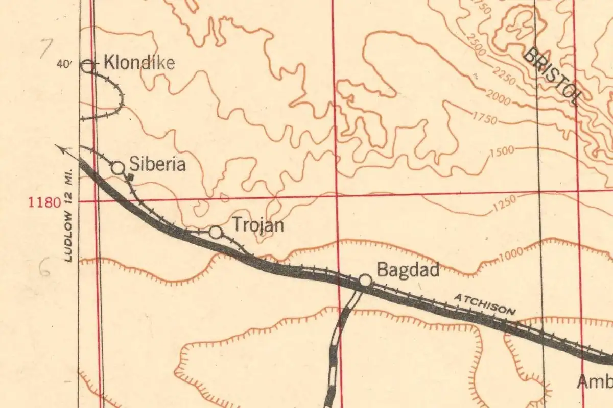
If you drive old Route 66 east from Amboy, the names start to look like a pattern. They are one, mostly. Erwin G. Gudde’s California Place Names says the railroad named its stations from Amboy to the Arizona line in alphabetical order in 1883: Amboy, Bristol, Cadiz, Danby, Edson, Fenner and Goffs. The C was Cadiz, a station the Atlantic and Pacific named in 1883, “perhaps after a town of the same name in the East,” according to the 1998 edition of Gudde.
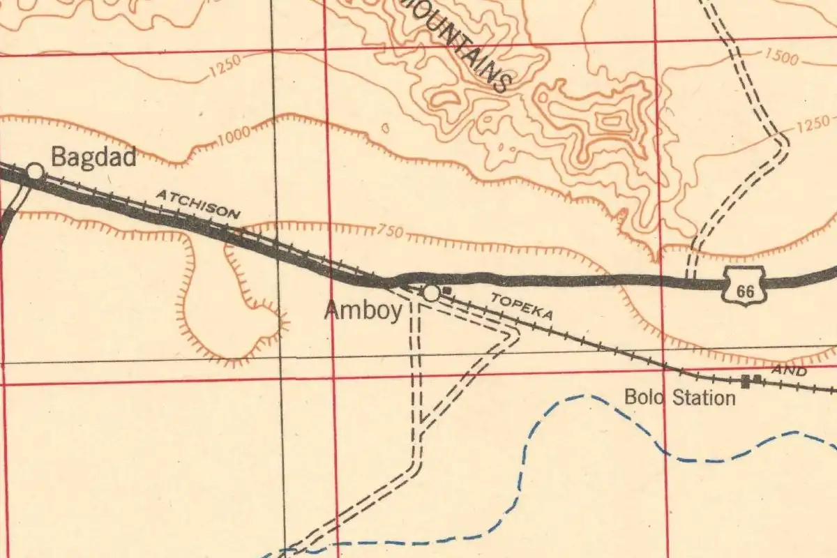
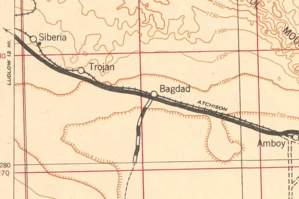
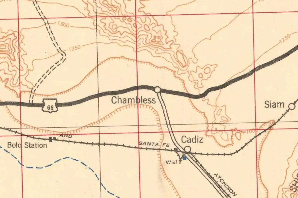
Chambless isn’t on that list, and it isn’t a railroad station. The 1942 Army map at the top of this page shows the difference. Cadiz sits on the Santa Fe tracks. Chambless sits on U.S. 66, right where the road to Cadiz turns south, about 3 miles (5 km) away by the federal map coordinates. Amboy is about 11 miles (18 km) to the west.
You also won’t find Chambless in the classic name books. A full-text search of Gudde (the 1969 and 1998 editions) and of Phil Townsend Hanna’s 1946 Dictionary of California Land Names didn’t turn up an entry for it. The story of the name comes from Route 66 histories instead, and all of them are fairly recent: the oldest we found is from 2000. We didn’t find a record from the family’s own time that says who the place was named for.
James Albert Chambless and the homestead
They tell it the same way, though the first two aren’t separate voices. A 2015 corridor plan for Route 66, prepared for the Bureau of Land Management and the California Historic Route 66 Association, says “the town of Chambless was named for homesteader James Albert Chambless,” who settled near the National Trails Road and Cadiz Road in the early 1920s. The association’s own page says the town takes its name from “James Albert Chambless and his family, who homesteaded here in the 1920s.”
Quinta Scott’s Along Route 66 (2000) fills in the family. Chambless was a widower who came west from Arkansas in the 1920s with his children, Melvane and Pearl, and settled near Amboy. When they saw a chance in the Cadiz Valley, Scott writes, each of them took a 160-acre desert homestead. They mined their land and opened a roadside business on the newly designated U.S. 66. Russell A. Olsen’s Route 66 Lost & Found (2011) also has a widower named James A. Chambless arriving from Arkansas with his two children in the 1920s.
The corridor plan puts the first store at the site in the late 1920s, after the old road was designated Route 66.
Moving with the highway
Then the road moved. When Route 66 was realigned in 1932, Scott says, the family moved with it and built Chambless Camp. The Route 66 association says the family sold the original store site and opened a new store and cabins on the newer path, the one Route 66 still uses. Olsen says Chambless built the small camp out of handmade blocks in 1932, hoping to cash in on the auto-tourist trade.
According to the corridor plan, Chambless added a gas station and motel in 1932, and a post office, a cafe and a row of concrete block cabins in 1939. We couldn’t confirm that post office in the Postal Service’s own Postmaster Finder, which has no entry under the name Chambless. Wells drilled into the Cadiz aquifer made it possible to plant trees, the plan says, and the shade made Chambless a popular stop. In the late 1930s, James married Fannie Gould, Scott writes, and she ran the place, “turning the camp into an oasis, complete with rose garden and fishpond.”
Mere dots on the desert’s face
The name shows up in print by the end of the decade. The WPA’s 1939 guide to California, driving west on US 66, didn’t give it much room:
“SUMMIT, 73.5 m., and CHAMBLESS, 76.5 m. (800 alt.), mere dots on the desert’s face, provide gas pumps, tourist camps, cafes.”
That “SUMMIT” is the pass 3 miles (5 km) east, which federal maps call Cadiz Summit. Seven years later, Jack Rittenhouse’s 1946 Guide Book to Highway 66 noticed the trees:
“CHAMBLESS. (Alt. 800’.) A wide-porched gas station, with a cafe and several tourist cabins. One of the few shady spots in the entire desert route.”
So a family surname had become a place you could find in a guidebook and on a federal map. The 1942 Army sheet prints it in the same lettering as Cadiz.
Road Runner’s Retreat and the bypass
About a mile (1.6 km) west of Chambless stands the tall sign of Road Runner’s Retreat, a later restaurant and gas station. Its sources don’t agree on its start. The Route 66 association says it opened in 1962; Route 66 News says Roy and Helen Tull built it in the early 1960s; the corridor plan says the late 1950s. It isn’t the Chambless family’s business, and it doesn’t explain the name.
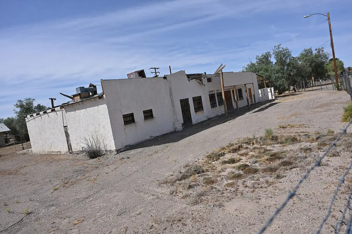
Interstate 40 ended the trade for both. A 1992 marker put up by the Billy Holcomb Chapter of E Clampus Vitus, at the corner of the National Trails Highway and Cadiz Road, says the old road “was bypassed by Interstate 40 in 1973.” The corridor plan says the Chambless businesses closed after I-40 opened in the early 1970s, and the Route 66 association’s page says Road Runner’s Retreat closed after I-40 bypassed the area in 1974. In 2015, the plan described the Chambless store and tourist cabins as vacant. In April 2024, Route 66 News reported that the Road Runner’s Retreat sign had been repainted, with its neon tubing next in line for restoration.
If you stop at the marker, it says it plainly: “Chambless, where you now stand, was a typical roadside stop.” The railroad’s alphabet gave Cadiz its letter. Chambless got its name the other way, from the people who sold the gas.
Quick answers
Is Chambless one of the Route 66 alphabet towns?
No. Gudde’s list of the 1883 railroad stations runs Amboy, Bristol, Cadiz, Danby, Edson, Fenner and Goffs. The C is Cadiz, about 3 miles south. Chambless is a highway stop named for a family.
Who was Chambless named after?
James Albert Chambless, according to a 2015 Route 66 corridor plan and the California Historic Route 66 Association, which helped prepare it. He homesteaded near the old National Trails Road and Cadiz Road in the 1920s and ran a store and then Chambless Camp. These sources are recent; we didn’t find a naming record from the time.
When did the Chambless family open Chambless Camp?
In 1932, when Route 66 was realigned, according to Scott and Olsen. The corridor plan says a first store stood at the site in the late 1920s.
Is Road Runner’s Retreat part of Chambless?
It’s a separate, later business about a mile west. It opened in the late 1950s or early 1960s, depending on the source, and its sign was repainted in 2024.
Key dates
- 1920sJames Albert Chambless, a widower from Arkansas, and his children settle near Amboy and take up desert homesteads; the federal corridor plan says early 1920s.
- 1932Route 66 is realigned and the family builds Chambless Camp on the new road, with a gas station and motel.
- 1939The WPA guide lists Chambless on US 66 with gas pumps, tourist camps and cafes. The corridor plan dates the Chambless post office to the same year.
- 1942The Army's Amboy map sheet labels Chambless on U.S. 66 at the road to Cadiz.
- 1946Jack Rittenhouse calls Chambless one of the few shady spots on the desert route.
- 1962Road Runner's Retreat opens about a mile west, according to the Route 66 association. Other sources say late 1950s or early 1960s.
- 1973Interstate 40 bypasses the old road, says the E Clampus Vitus marker at Chambless.
- 2024The Road Runner's Retreat sign is repainted.
Getting there
Open Chambless in Google Maps
Opens in a new tab. The pin is the center of Chambless in the USGS place-name record.
The closest airports, Amtrak stations and intercity bus stops, measured in a straight line from the center of Chambless.
Airports
- Laughlin/Bullhead International (IFP) Bullhead City 69 mi 112 km
- Palm Springs International (PSP) 75 mi 120 km
- Harry Reid International (LAS) Las Vegas 107 mi 173 km
Amtrak trains
- Needles station (NDL) 57 mi 91 km
- Palm Springs station (PSN) 73 mi 118 km
Distances are as the crow flies, not by road. We don't list schedules or fares because they change; check with the airline, Amtrak or the bus company before you go. Official data (FAA commercial service airports (2025), FAA airport locations, Amtrak stations and Intercity Bus Atlas) from the FAA and the U.S. Bureau of Transportation Statistics, checked Nov 11, 2026.
Sponsored
Staying in Chambless?
Compare hotels in Chambless, California, on Expedia.
See hotels in ChamblessWe may earn a commission if you buy through this link. It never changes what we write. Read our affiliate disclosure
Historical Sources & References
- California Historic Route 66 Needles to Barstow Corridor Management Plan, final draft (May 2015). Prepared for the Bureau of Land Management and the California Historic Route 66 Association. p. 91 and pp. 99-100: Chambless “named for homesteader James Albert Chambless,” who settled near the National Trails Road and Cadiz Road in the early 1920s; a store in the late 1920s; a gas station and motel in 1932; the post office, cafe and concrete block cabins in 1939; wells into the Cadiz aquifer; closing after I-40 in the early 1970s; the store and cabins vacant; Road Runner’s Retreat “built in the late 1950s.”
- California Historic Route 66 Association, “Chambless”. The name from “James Albert Chambless and his family, who homesteaded here in the 1920s”; the first store on the National Old Trails Road and the move to the new alignment in the early 1930s; Road Runner’s Retreat “just 1 mile west,” opened in 1962 and closed after I-40 bypassed the area “in 1974.”
- Quinta Scott, Along Route 66 (2000). p. 254 (by the book’s index): James Albert Chambless, a widower, and his children Melvane and Pearl, from Arkansas in the 1920s; the 160-acre homesteads; the business on the new U.S. 66; the 1932 move and Chambless Camp; Fannie Gould. Read in search excerpts.
- Russell A. Olsen, Route 66 Lost & Found (2011). pp. 379-380: James A. Chambless, a widower from Arkansas with two children, in the 1920s; Chambless Camp built of handmade blocks in 1932. Read in search excerpts.
- Federal Writers’ Project, California: A Guide to the Golden State (1939). Tour 12 (US 66), p. 611: Summit and Chambless, “mere dots on the desert’s face.”
- Jack D. Rittenhouse, A Guide Book to Highway 66 (1946). The Chambless entry: “One of the few shady spots in the entire desert route.” Read in search excerpts, without a page number.
- Erwin G. Gudde, California Place Names, 3rd ed. (1969). Entry “Amboy”: the stations from Amboy to the Arizona line named in alphabetical order, Amboy, Bristol, Cadiz, Danby, Edson, Fenner and Goffs. No entry for Chambless found. Also online: Gudde, 4th ed., revised by William Bright (1998), entry “Cadiz”: named in 1883 by the Atlantic and Pacific, “perhaps after a town of the same name in the East.” No entry for Chambless found. Both read in search excerpts, without page numbers.
- Phil Townsend Hanna, The Dictionary of California Land Names (1946). Searched for Chambless; no entry found.
- E Clampus Vitus, “Old Route 66” marker (1992), Historical Marker Database. At National Trails Highway and Cadiz Road: “Chambless, where you now stand, was a typical roadside stop”; bypassed by Interstate 40 in 1973.
- Ron Warnick, “Road Runner’s Retreat sign near Chambless is repainted,” Route 66 News (April 30, 2024). Roy and Helen Tull built the business in the early 1960s; it closed in the mid-1970s; the sign repainted in 2024.
- U.S. Postal Service, Postmaster Finder. Search “Chambless, California”: no entry. The nearby Cadiz office lists postmasters only from 1959.
- U.S. Army Corps of Engineers, Amboy sheet (1942). The map at the top of this page, the oldest in the USGS historical collection that covers Chambless.
- GNIS feature 240463, Chambless (U.S. Geological Survey). The Geographic Names Information System’s populated-place entry for Chambless, on the Cadiz map sheet, with its coordinates.
Sponsored
Gear up for your next road trip
Explore rooftop tents, vehicle awnings and outdoor gear from TOPOAK Overland.
Shop TOPOAK overlanding gearWe may earn a commission if you buy through this link. It never changes what we write. Read our affiliate disclosure
Spot something wrong, or know more? Tell us here. You can also email us or use our contact page. Corrections are noted here with their date, never made silently.