Why Is It Called Crested Butte? The Peak Came First
Crested Butte takes its name from a mountain. An 1881 guide to Colorado says the mining camp was named for Crested Butte Peak, which got its name from its crested look. The peak was already called Crested Butte in the federal survey's 1873 report, before the town existed, and none of these early sources says who coined it.
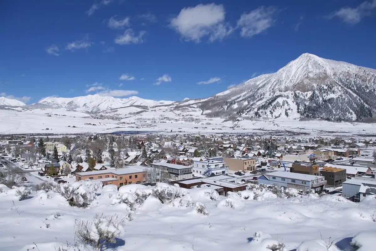
The mountain had the name first: Crested Butte, Colorado, is named for the lone peak above town, which was called that for its crested shape. When the mining camp showed up a few years later, it simply borrowed the biggest thing in view.
“The peculiar crested appearance”
George Crofutt’s 1881 travel guide to Colorado gave Crested Butte a short entry. It was a small mining camp of about 200 people, he wrote, with three stores, a hotel, a sampling works and “a score of saloons, restaurants and shops,” sitting where Slate and Coal Creeks meet. Then he explained the name:
“The town was named for Crested Butte Peak, half-mile to the eastward, which derived its name from the peculiar crested appearance which it presents.”
He went on about the summit’s “spires, castellated rocks, domes, and pinnacles,” so he clearly thought the shape was the point. One detail is off, though. Measured on a map today, the summit sits about 2.5 miles (4 km) northeast of downtown, not half a mile.
Two years later, John K. Hallowell, writing for a Denver mining museum, said the same thing in his own words: the railroad up the Slate River ended at “the town of Crested Butte, the place taking its name from the most prominent landmark at the entrance to this geological basin.”
On the survey’s list by 1873
The peak had its name before there was any town to hand it to. In 1873, Ferdinand V. Hayden’s federal survey of the territories worked through the Elk Mountains, and Hayden’s report for that year mentions “Gothic Mountain, 12,315, and Crested Butte, 11,838 feet high” as “immense dikes,” melted rock pushed up through the layers of shale above. The survey geologist A. C. Peale put the names in quotation marks, “Crested Butte” and “Gothic Butte,” and noted that “they are both isolated, and rise considerably higher than the surrounding country.”
Henry Gannett, the topographer in charge of the survey’s middle division in 1874, described the ridge between the East and Slate rivers as three separate mountains. The southern one, he wrote, “stands entirely alone, in the angle of the two streams, and rises 3,000 feet above the saddle north of it.”
So who first called it Crested Butte? The reports don’t say. You’ll sometimes read that Hayden named it and compared it to the crest of a helmet, but that line isn’t in his reports for 1873 or 1874, which use the name without explaining it. What the record does show is the name already in use during that 1873 season.
The same name, twice on one map
Thirty years later, Gannett wrote the name up himself. In 1905 his book for the U.S. Geological Survey, The Origin of Certain Place Names in the United States, put the whole story in two sentences: the town in Gunnison County was “named for a conical, gray peak which dominates the valley,” and “the mountain derives its name from its shape.”
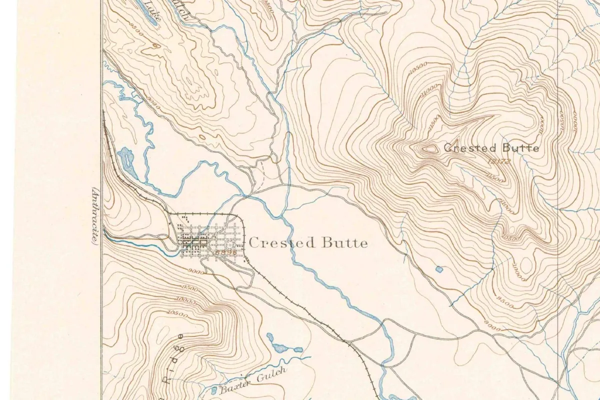
Both show up on the survey’s 1888 Crested Butte sheet. The little street grid by the Slate River is labeled Crested Butte, and so is the knot of tight contour lines off to the northeast. If you’ve ever been confused about whether someone means the town or the mountain, the mapmakers had the same problem.
It didn’t get simpler over time. The federal place-name database today lists a peak called Crested Butte, a town called Crested Butte and, up the slope, a second town called Mount Crested Butte. Three places in Colorado, one mountain’s name, and it all goes back to a peak somebody thought looked crested.
Quick answers
Why is Crested Butte called Crested Butte?
Because of the mountain. Crofutt’s 1881 guide says the town was named for Crested Butte Peak, which got its name from its “peculiar crested appearance,” and Gannett’s 1905 book says the same.
Did Hayden name Crested Butte?
Not that the record shows. The Hayden survey’s report for 1873 already uses the name Crested Butte for the peak, but it doesn’t say who chose it or why.
Which came first, the town or the mountain?
The mountain. Its name appears in the survey’s 1873 report; the mining camp named after it shows up in the 1881 guide.
Key dates
- 1873The Hayden survey's report for the year lists Crested Butte, 11,838 feet, beside Gothic Mountain in the Elk Mountains.
- 1874Henry Gannett describes Crested Butte as a peak that stands entirely alone between the East and Slate rivers.
- 1881Crofutt's guide calls Crested Butte a mining camp of about 200 people, named for Crested Butte Peak.
- 1883Hallowell writes that the railroad's terminus on the Slate River takes its name from the most prominent landmark.
- 1888The U.S. Geological Survey's Crested Butte sheet labels both the town and the peak Crested Butte.
Getting there
Open Crested Butte in Google Maps
Opens in a new tab. The pin is the center of Crested Butte in the USGS place-name record.
The closest airports, Amtrak stations and intercity bus stops, measured in a straight line from the center of Crested Butte.
Airports
- Gunnison-Crested Butte Regional (GUC) 23 mi 38 km
- Aspen-Pitkin County/Sardy Field (ASE) 25 mi 40 km
- Denver International (DEN) 141 mi 227 km
Amtrak trains
- Glenwood Springs station (GSC) 50 mi 81 km
- Grand Junction station (GJT) 86 mi 138 km
Intercity buses
- Bustang Outrider Bustang · Crested Butte under 1 mi 0.6 km
- Colorado Department of Transportation Bustang · West Glenwood Park & Ride 51 mi 83 km
- Greyhound Glenwood Springs W Glenwood Mall 52 mi 83 km
Distances are as the crow flies, not by road. We don't list schedules or fares because they change; check with the airline, Amtrak or the bus company before you go. Official data (FAA commercial service airports (2025), FAA airport locations, Amtrak stations and Intercity Bus Atlas) from the FAA and the U.S. Bureau of Transportation Statistics, checked Nov 13, 2026.
Sponsored
Staying in Crested Butte?
Compare hotels in Crested Butte, Colorado, on Expedia.
See hotels in Crested ButteWe may earn a commission if you buy through this link. It never changes what we write. Read our affiliate disclosure
Sponsored
Want the spooky side of Crested Butte?
The name has its story above. For the ghost stories, US Ghost Adventures runs walking ghost tours in Crested Butte.
See ghost tours in Crested ButteWe may earn a commission if you book through this link. It never changes what we write. Read our affiliate disclosure
Historical Sources & References
- George A. Crofutt, Crofutt’s Grip-Sack Guide of Colorado (1881), p. 89. The camp of about 200 people where Slate and Coal Creeks meet, and the line that the town “was named for Crested Butte Peak,” which “derived its name from the peculiar crested appearance which it presents.”
- John K. Hallowell, Gunnison, Colorado’s Bonanza County (1883), p. 7. The railroad up the Slate River ending at Crested Butte, “the place taking its name from the most prominent landmark.”
- F. V. Hayden, Annual Report of the U.S. Geological and Geographical Survey of the Territories for 1873 (1874), pp. 69 and 256. Hayden’s mention of “Gothic Mountain, 12,315, and Crested Butte, 11,838 feet high” (p. 69) and A. C. Peale’s description of “Crested Butte” and “Gothic Butte” as isolated peaks (p. 256). Also online: p. 256.
- F. V. Hayden, Annual Report for 1874 (1876), report of Henry Gannett, p. 419. Gannett’s description of Crested Butte as the southern of three mountains, standing “entirely alone, in the angle of the two streams.”
- Henry Gannett, The Origin of Certain Place Names in the United States (USGS, 1905), p. 95. The town “named for a conical, gray peak which dominates the valley,” and the mountain named “from its shape.”
- GNIS feature 188848 (U.S. Geological Survey). Crested Butte’s entry as a town in Gunnison County. The same database keeps the peak (feature 188762) and Mount Crested Butte (feature 197451) as separate records.
- U.S. Geological Survey, Crested Butte sheet (1:62,500), 1888. The 1888 sheet that labels both the town and the peak Crested Butte.
Spot something wrong, or know more? Tell us here. You can also email us or use our contact page. Corrections are noted here with their date, never made silently.