How Leadville, Colorado, Got Its Name in January 1878
Leadville is named for its lead ore. In January 1878, eighteen citizens met to organize a town and debated names like Carbonateville, Harrison and Agassiz. According to Frank Hall's 1890 history, J. C. Cramer proposed Leadville as the name most suggestive of the camp's wealth, and it was adopted unanimously.
Eighteen citizens at a January 1878 meeting picked the name Leadville, Colorado, for the lead ore around them, ore that was really valued for its silver. They turned down Carbonateville, Harrison and Agassiz to get there.
The heavy sand in California Gulch
Gold came first in this valley. The miners washing gravel in California Gulch kept complaining about what Frank Hall’s 1890 history calls “the heavy porphyry, heavy spar and sand that troubled them.” Two men running a new water ditch in the gulch, W. H. Stevens and Alvinus B. Wood, wanted to know what it was and had it analyzed. The result “proved it to be a rich carbonate of lead, carrying silver, properly a silver ore.”
In other words, the junk was the jackpot. Stevens and Wood located claims they called the Rock, the Stone and the Lime in June 1874 and started digging. In the summer of 1877, according to the 1881 History of the Arkansas Valley, Hallock and Cooper found the Carbonate Mine, which gave Carbonate Hill its name. By the end of that year Hall counts about 300 people in the camp, and a storekeeper named H. A. W. Tabor had merged his stores at Oro and Malta and moved to Leadville, “taking with him the post office.”
Carbonateville, Harrison, Agassiz or Leadville
What the camp didn’t have was a name everyone agreed on. Hall quotes the Leadville Chronicle on the meeting that settled it:
“There was high debate over the name. Mr. Mater suggested ‘Carbonateville.’ A. R. Meyer proposed ‘Harrison’ as a fitting compliment to the builder of the first smelter. A few others favored ‘Agassiz.’ Mr. J. C. Cramer proposed ‘Leadville’ as the name most distinctly suggestive of the new city’s source of wealth, and it was unanimously adopted.”
Carbonateville would have named the ore, and Harrison a smelter builder. Cramer’s pitch, as the paper reported it, was that Leadville pointed straight at the source of the money, and the room agreed.
The details depend on which book you open. Hall’s quote puts eighteen citizens in “a little wagon shop” on the corner of Pine and Chestnut streets on January 14, 1878, then adds a footnote that “other authorities assert that the meeting was held in Chas. Mater’s store.” The 1881 history is one of those authorities. It says eighteen citizens met “at the common rendezvous—the store of Charles Mater” on January 18 and, “after an animated debate, selected the name of ‘Leadville,’” then asked the governor to incorporate the town. It doesn’t name who suggested it.
Where Tabor fits in
If you’ve read about Leadville online, you’ve probably seen Horace Tabor get the credit. The local tourism timeline says that in 1878, “when the town petitioned for its first post office,” Tabor gave it its official name. It doesn’t cite a document for that.
The two older histories tell it differently. Both give the choice to the town meeting, and Hall’s quote hands the winning suggestion to Cramer. Tabor’s turn came right after: both books say he was elected the first mayor in 1878, with Mater and Cramer among the trustees. In April 1879, Hall says, the town was made a city of the first class. So Tabor ran the new town and brought it the post office. Naming it is the one part the old record gives to somebody else.
Lead, Leadville and one shared line
By 1905, Henry Gannett’s federal book on place names had boiled it down to a single entry shared by three towns: Lead, South Dakota, Lead Hill, North Carolina, and Leadville. All of them, he wrote, were “So named on account of the species of ore found within their limits.” That fits Leadville well. In Lead, two early histories say the name came from “leads,” the veins of ore, which is a different story.
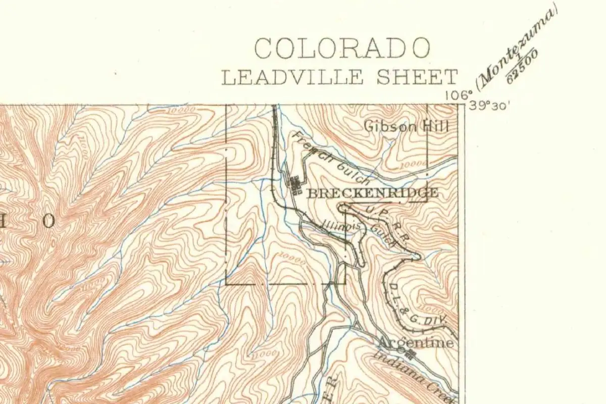
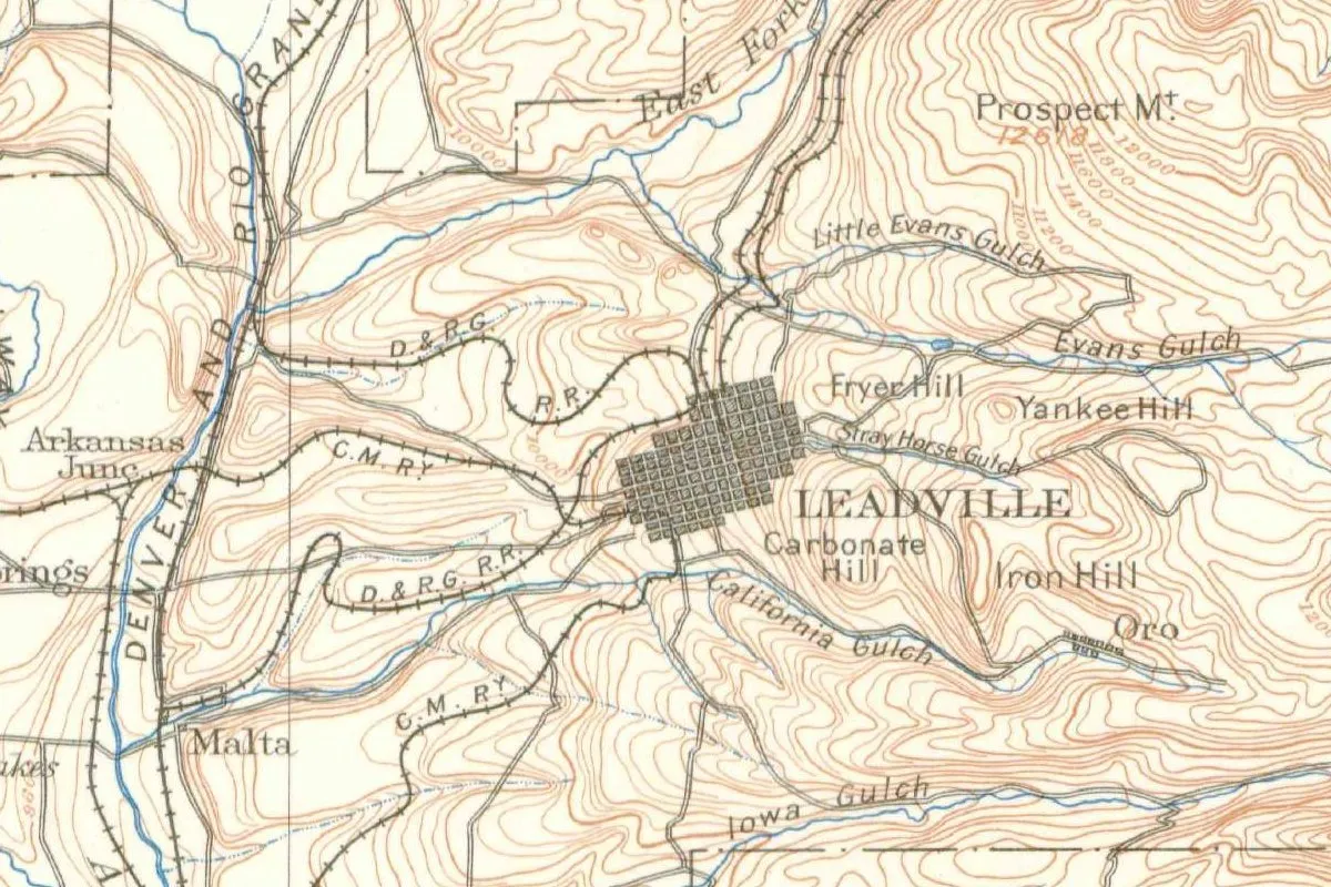
The 1889 survey map of the area shows how much the ore shaped the place. LEADVILLE sits in the middle of the sheet, with Fryer Hill, Carbonate Hill and Iron Hill to the east, Oro up California Gulch and Malta to the southwest. The silver paid the bills, but it’s the lead you hear every time somebody in Colorado says the town’s name.
Quick answers
Who named Leadville?
A meeting of eighteen citizens in January 1878. Frank Hall’s 1890 history, quoting the Leadville Chronicle, says J. C. Cramer proposed the name and it was adopted unanimously; a modern tourism timeline credits Horace Tabor instead.
Is Leadville named after lead?
Yes. The ore that started the boom was a lead carbonate carrying silver, and Cramer proposed it as the name “most distinctly suggestive” of that wealth, and the meeting adopted it, according to Hall.
What other names were suggested for Leadville?
Carbonateville, from Charles Mater; Harrison, after the builder of the first smelter, from A. R. Meyer; and Agassiz, which a few others favored.
Key dates
- 1874After the heavy sand in California Gulch tests as lead carbonate carrying silver, Stevens and Wood locate the Rock, Stone and Lime claims in June.
- 1877Summer: Hallock and Cooper discover the Carbonate Mine, which gives Carbonate Hill its name.
- 1878January: a meeting of eighteen citizens chooses the name Leadville. Hall dates it to the 14th, the 1881 history to the 18th.
- 1878H. A. W. Tabor is elected the town's first mayor.
- 1879April: Leadville becomes a city of the first class, according to Hall.
- 1889The U.S. Geological Survey's Leadville sheet prints LEADVILLE between Fryer Hill and Carbonate Hill.
Getting there
Open Leadville in Google Maps
Opens in a new tab. The pin is the center of Leadville in the USGS place-name record.
The closest airports, Amtrak stations and intercity bus stops, measured in a straight line from the center of Leadville.
Airports
- Aspen-Pitkin County/Sardy Field (ASE) 31 mi 50 km
- Eagle County Regional (EGE) 43 mi 69 km
- Denver International (DEN) 96 mi 155 km
Amtrak trains
- Winter Park station (WPR) 52 mi 84 km
- Fraser-Winter Park station (WIP) 54 mi 88 km
Intercity buses
- Bustang Outrider Bustang · Fairplay 16 mi 26 km
- OurBus Copper Mountain, CO (In front of the Copper Lodge at 509 Copper Rd, Copper, CO. Look for a van with Peak 1 Express written on it.) 19 mi 30 km
- Colorado Department of Transportation Bustang · Frisco Transit Center 26 mi 41 km
Distances are as the crow flies, not by road. We don't list schedules or fares because they change; check with the airline, Amtrak or the bus company before you go. Official data (FAA commercial service airports (2025), FAA airport locations, Amtrak stations and Intercity Bus Atlas) from the FAA and the U.S. Bureau of Transportation Statistics, checked Nov 13, 2026.
Sponsored
Staying in Leadville?
Compare hotels in Leadville, Colorado, on Expedia.
See hotels in LeadvilleWe may earn a commission if you buy through this link. It never changes what we write. Read our affiliate disclosure
Sponsored
Want the spooky side of Leadville?
The name has its story above. For the ghost stories, US Ghost Adventures runs walking ghost tours in Leadville.
See ghost tours in LeadvilleWe may earn a commission if you book through this link. It never changes what we write. Read our affiliate disclosure
Historical Sources & References
- Frank Hall, History of the State of Colorado, vol. 2 (1890), pp. 429-430, 446-447. Stevens and Wood’s analysis of the heavy sand as “a rich carbonate of lead, carrying silver” and the claims of June 1874 (pp. 429-430); the population of about 300 at the end of 1877, the Chronicle’s account of the January 14, 1878, meeting and the four names proposed, with the footnote about Mater’s store (p. 446); Tabor as first mayor and the city of the first class in April 1879 (p. 447). Also online: pp. 429-430.
- History of the Arkansas Valley, Colorado (O. L. Baskin & Co., 1881), pp. 218, 220, 225, 237. The Carbonate Mine and Carbonate Hill (p. 218); Tabor moving his store from Oro and “taking with him the post office” (p. 220); the meeting at Charles Mater’s store on January 18 that selected the name (p. 225); Tabor elected mayor, with Mater and Cramer as trustees (p. 237). Also online: p. 220.
- Henry Gannett, The Origin of Certain Place Names in the United States (USGS, 1905), p. 183. The shared entry for Lead, Lead Hill and Leadville, “So named on account of the species of ore found within their limits.”
- Leadville / Twin Lakes, “A Time Line of Leadville’s History”. The modern version that credits Horace Tabor with the name when the town petitioned for its first post office.
- GNIS feature 204683 (U.S. Geological Survey). Leadville’s record as a populated place in Lake County.
- U.S. Geological Survey, Leadville sheet (1:125,000), 1889. The 1889 sheet with Leadville, Fryer Hill, Carbonate Hill, Oro and Malta.
Spot something wrong, or know more? Tell us here. You can also email us or use our contact page. Corrections are noted here with their date, never made silently.