Washington, D.C. Names: White House, K Street and More
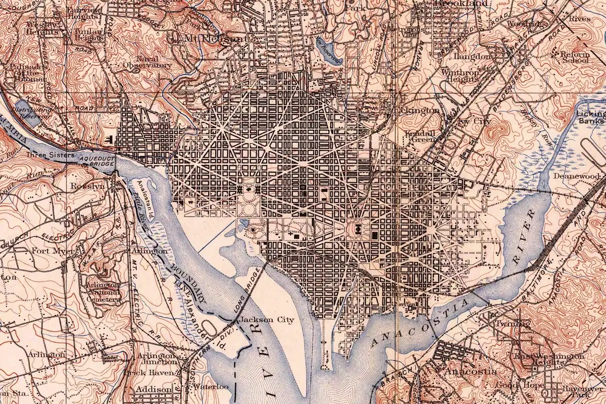
Washington, D.C. place names come from a 1791 street plan, the old farms and towns the city swallowed, and nicknames that stuck, like the White House. K Street is just the letter K in that plan, Capitol Hill used to be Jenkins Hill, and Foggy Bottom was the name of an unhealthy stretch of riverfront.
Planning a trip? Here’s where the names on your map came from. Most of the street names were set by a few lines in a 1791 letter, so they’re easy to decode. The neighborhood names are older or odder, and a couple of them, like the White House, have more than one story behind them.
Where Washington got its name
The city is named for George Washington, and the district around it is Columbia. The commissioners who ran the new capital announced both names in a letter of September 9, 1791. Our District of Columbia page goes through that letter, where the name Columbia came from, and what the letter leaves out.
Streets and avenues
K Street and the lettered streets
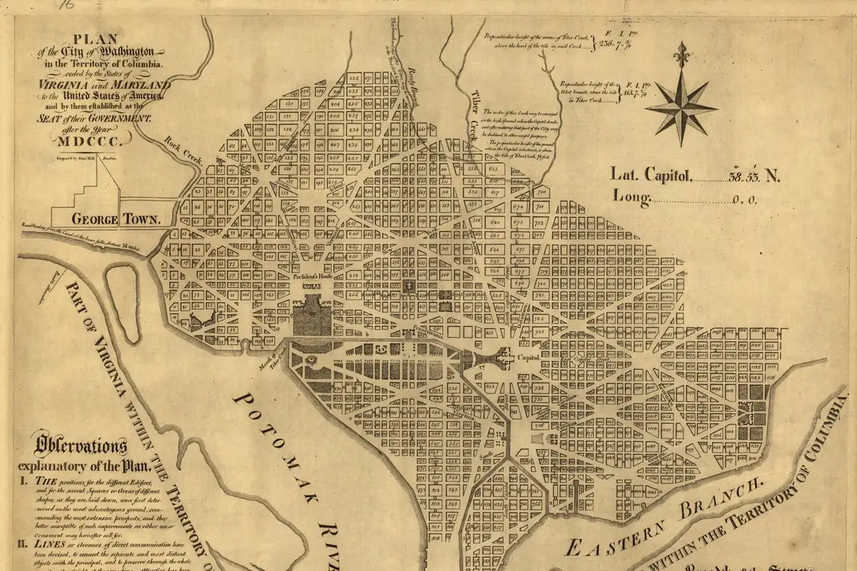
K Street is named for the letter K, and that’s the whole story. William Tindall’s 1914 history of the city prints the commissioners’ letter of September 9, 1791, to Pierre L’Enfant, the planner of the city. They wrote that they had “agreed the streets be named alphabetically one way, and numerically the other; the former divided into North and South letters, the latter into East and West numbers from the Capitol.” So the letters (A, B, C…) run one way and the numbers (1st, 2nd, 3rd…) the other, all counted out from the Capitol.
Pennsylvania Avenue and the state avenues
The big diagonal avenues are named for states. Wilhelmus Bryan’s 1914 history of the capital says no record mentions how the avenues were named, and the names aren’t on the L’Enfant map that survives, but they are on the engraved plan. Fifteen of them had the names of the states that had joined the union by 1792, the same names they still had in Bryan’s day, except that Georgia Avenue was later changed to Potomac Avenue. Bryan says Tennessee, Ohio, Louisiana and Indiana went on avenues that had no names on the map.
The Mall and the White House
The National Mall
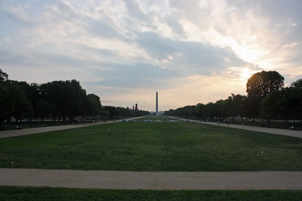
The Mall was first just “the walk.” Bryan says the engraved plan of the city showed “the walk, or, as it came to be called, the Mall,” along with the garden around the president’s house and Lafayette Square. That’s as far as the old books go: none we read explains where the word Mall came from.
The White House
The White House was officially the President’s House, and the old books we read give three different accounts of the nickname.
- It was painted, and called white, before 1814. Bryan quotes a 1798 report by James Hoban, who was in charge of building it, about “cleaning down and painting the wall of the building.” In a note, Bryan adds that people commonly supposed the name came from painting over the smoke stains after the British burned the building in 1814, but “the name was in current use prior to the destruction of the building.” He doesn’t show a document for that last part.
- It was painted white after the fire. Tindall doesn’t talk about the name, but he says that after the British destroyed the interior in 1814, the house was rebuilt within the original walls, “which like those of the Capitol were painted white to obliterate the marks of the fire.” That’s the version Bryan says “is commonly supposed.”
- It was named for Martha Washington’s old home. Rufus Rockwell Wilson wrote in 1902 that the mansion “was soon given the name of White House,” and that “tradition has it” the name honored Martha Washington, whose early home on the Pamunkey River in Virginia had the same name.
The one thing with a document behind it is Hoban’s 1798 report, which shows the walls were being painted long before the fire. Nobody we read pins down the first time someone called it the White House.
Capitol Hill and the Tiber
Capitol Hill
Capitol Hill used to be Jenkins Hill. Bryan says L’Enfant pointed to “Jenkins Hill, now known as Capitol Hill,” as the best spot for the public buildings. Tindall prints L’Enfant’s own report, which praises “the west end of Jenkins heights” as a spot that “stand as a pedestal waiting for a monument.” (Tindall adds “Capitol Hill” in parentheses so readers know which hill.)
Rome and the Tiber
Before there was a city, there was a farm called Rome. Bryan says a 400-acre tract by that name was surveyed for Thomas Pope on June 5, 1663, and later owned by Francis Pope. He quotes bits of the survey certificate, recorded in Maryland’s land records, which describes one of its lines running to:
“a bounded oak standing at the north of a bay or indent called Tiber.”
Bryan says that certificate “has perhaps made it the best known of all the ancient records of this locality.” Tindall prints the same certificate a little differently: in his copy the land is “Layd out for Francis Pope” and the line runs to “a bounded oak standing at the mouth of a bay or inlet called Tiber.” The two books don’t agree on which Pope or on the exact words.
Bryan says nobody can tell the exact spot from the description, but it’s held to have been inside the original bounds of Washington. Tindall says Francis Pope named his place Rome and called the small stream at the foot of his hill the Tiber. Then he adds a story: “It is told of this dreamer” that Pope had a vision of a splendid parliament house on the hill and called his land Rome “in prophetic honor of the great city to be.” Tindall writes the dream as something people told, and we can’t check it.
The creek at the foot of the hill had a plainer name too. Bryan says L’Enfant’s 1791 map calls it the Tiber, but at the time it was also known as Goose Creek.
Neighborhoods
Foggy Bottom
Foggy Bottom was the name of an unhealthy stretch of riverfront. Bryan, in the second volume of his history, describes how the river flats had a reputation as a cause of “chills and fevers,” and says that by the early 1850s “the section of the river front near the termination of G Street bore the name of Foggy Bottom.” When gasworks opened there in 1859, residents hoped the fumes would “disinfect the Foggy Bottom chill.” Elsewhere Bryan lists Foggy Bottom, “in the vicinity of the south end of New Hampshire Avenue,” among the city’s rough neighborhoods of the 1850s. He never spells out where the name came from.
Hamburg, or Funkstown
Part of the riverfront around today’s 19th to 23rd streets was a town before Washington existed. Bryan says Jacob Funk, a German living near Frederick, Maryland, divided his land into building lots in 1768, “making a town site called Hamburg, and also known as Funkstown.” Bryan says it ran from a little west of today’s 19th Street to west of 23rd Street. Tindall puts its east edge a bit farther east, about midway between 18th and 19th streets, and its north edge at about H Street. Both say it had 287 lots, and Tindall adds that it sat just above the mouth of Goose, or Tiber, Creek.
Georgetown
Georgetown is older than Washington. Bryan says a Maryland law of 1751 authorized laying out the town on land next to “the inspection house called George Gordon’s Rolling House,” and that the 60 acres picked for it were taken from land owned by two men, George Gordon and George Beall. Beall didn’t want to sell and accepted his lots with the words “God save King George!” In a footnote Bryan says “it is supposed” the town’s name carries on Beall’s. That’s a guess in his book, not a record, so treat it as one.
Kalorama
Kalorama was named by a poet. Bryan says Anthony Holmead sold part of his land in 1795 to Gustavus Scott, one of the city’s commissioners, and it later passed to Joel Barlow, “who gave it the name of Kalorama.” Rufus Rockwell Wilson calls Barlow a “patriot, poet, and man of affairs.”
Kendall Green
Kendall Green is named for the man who owned it. Bryan says Amos Kendall, a prominent figure in the Andrew Jackson administration, offered houses for sale on his property on the city’s northeast edge, and “Kendall Green, as he named the property,” was also called Kendallville. A few years later Kendall gave one of the houses to the new Columbia Institution for the deaf, dumb and blind, and as the school grew, “additional ground was occupied.”
Anacostia
Anacostia is a Native name. Bryan says the people who lived here before Europeans are “commemorated in the name Anacostia,” which the river also called the Eastern Branch still carries. The island in the Potomac across from Georgetown was once called Analostian or Anacostian Island, Bryan says, before it became Mason’s Island; the 1900 map at the top of this page labels it Analostan Island. Bryan also says a settlement south of the Eastern Branch was called Anacostia by the 1850s, and its post office later took the name Uniontown.
Names we’re still checking
You might be wondering about Dupont Circle, Logan Circle, Adams Morgan, Shaw, Penn Quarter, Embassy Row, Columbia Heights and the Navy Yard neighborhood. We haven’t yet found an old source we can show you that says how those names ended up on the map. Until we do, they stay off this page.
Quick answers
Why is it called the White House?
The old books disagree. Nobody knows for sure. Bryan (1914) says the name was already in use before the British burned the house in 1814, though “it is commonly supposed” the name came from painting over the fire damage; Wilson (1902) repeats a tradition that it was named for Martha Washington’s early home.
Why is it called K Street?
Because of the letter K. In 1791 the city’s commissioners decided the streets would be named alphabetically one way and numerically the other.
Why is it called Foggy Bottom?
Nobody we read explains it. Bryan says that by the early 1850s a stretch of riverfront near the end of G Street “bore the name of Foggy Bottom,” in an area known for damp river flats and “chills and fevers.”
Why is it called Capitol Hill?
It’s the hill the Capitol stands on. Before that it was Jenkins Hill, Bryan says, and L’Enfant picked it as the best spot for the public buildings.
Key dates
- 1663June 5: a tract of land called Rome is laid out for a member of the Pope family, with a line running to a bay called Tiber.
- 1751A Maryland law authorizes laying out the town of Georgetown on land owned by George Gordon and George Beall.
- 1768Jacob Funk divides his land into building lots and makes a town called Hamburg, also known as Funkstown.
- 1791September 9: the commissioners tell L'Enfant the streets will be named by letters one way and numbers the other.
- 1795Anthony Holmead sells part of his land; it later passes to Joel Barlow, who names it Kalorama.
- 1814The British burn the President's House, leaving the outer walls standing.
Sponsored
Planning a trip to Washington, D.C.?
Compare hotels in Washington, D.C. on Expedia.
See hotels in Washington, D.C.We may earn a commission if you buy through this link. It never changes what we write. Read our affiliate disclosure
Sponsored
Read up before your trip
Browse digital travel magazines on Magzter.
Browse travel magazinesWe may earn a commission if you buy through this link. It never changes what we write. Read our affiliate disclosure
Historical Sources & References
- Wilhelmus Bogart Bryan, A History of the National Capital, vol. 1 (1914). Anacostia and Analostian Island (pp. 47-48); the Rome survey of 1663 and the Tiber (p. 53); Goose Creek, the Tiber on L’Enfant’s map, Holmead and Kalorama (pp. 53-54); Georgetown, George Gordon and George Beall (pp. 58-59); Jacob Funk’s Hamburg, or Funkstown (p. 59); Jenkins Hill, now Capitol Hill (p. 136); the lettered and numbered streets and the state avenues (pp. 154-155); “the walk, or, as it came to be called, the Mall” (p. 185); the White House walls painted from the start, and the name in use before 1814 (p. 313 and note).
- Wilhelmus Bogart Bryan, A History of the National Capital, vol. 2 (1916). Foggy Bottom among the rough neighborhoods (p. 277); Foggy Bottom and the river flats (pp. 311-312); Kendall Green and Anacostia (p. 370).
- William Tindall, Standard History of the City of Washington (1914). Francis Pope’s Rome, the story of his dream and his survey certificate (p. 18); Hamburgh, or Funkstown (p. 65); L’Enfant’s report on “Jenkins heights” (p. 102); the commissioners’ letter of September 9, 1791 (p. 121); the walls painted white after 1814 (p. 435).
- Rufus Rockwell Wilson, Washington, the Capital City, vol. 1 (1902). The White House name and the Martha Washington tradition (p. 27); Joel Barlow, “patriot, poet” (p. 75).
- U.S. Geological Survey, Washington sheet (1900). The map at the top of this page, with Analostan Island, Anacostia and Kendall Green labeled.
Sponsored
Want a local to show you around?
Book a private tour of Washington, D.C., with a local guide on GoWithGuide. Each tour is just for your group, and you can change the plan with your guide before you go.
See private tours in Washington, D.C.We may earn a commission if you buy through this link. It never changes what we write. Read our affiliate disclosure
Sponsored
Live in the D.C. area with kids?
GetOut sells a yearly membership for family attractions around Washington, D.C., and Maryland. Check which places are included before you buy, and keep in mind it renews automatically every year unless you turn renewal off in your account.
See GetOut Maryland and D.C.We may earn a commission if you buy through this link. It never changes what we write. Read our affiliate disclosure
Spot something wrong, or know more? Tell us here. You can also email us or use our contact page. Corrections are noted here with their date, never made silently.