Why Is Boone, NC, Called Boone? A Frontiersman's Name
Boone is named for Daniel Boone, the frontiersman. Its post office, called Councill's Store since 1823, took the name Boone in 1850, a year after the legislature chose the spot as seat of the new Watauga County. John Preston Arthur's history of the county, published in 1915, ties the name to a hunting cabin Boone used near the courthouse.
Boone, North Carolina, is named for Daniel Boone, and a 1915 history says the town grew up a few hundred feet from a cabin he used on hunting trips. Before it was Boone, though, the place had a storekeeper’s name, and if you check the state’s laws, the town’s own name took a while to settle.
Why is Boone, NC, called Boone?
For Daniel Boone, the frontiersman. Reaching the B’s in the Geological Survey’s alphabet of names in 1905, Henry Gannett put the town in one entry with counties in six states plus one in West Virginia, then said it plainly: “Named for Daniel Boone; his name appears with different suffixes in many parts of the country.”
That’s the who. The why is local. John Preston Arthur’s A History of Watauga County, published in 1915, ties the name to a cabin. “When Watauga was formed,” he wrote, “the legislature called the county-seat Boone because of the location of Boone’s cabin within a few hundred feet of its court house.”
Arthur describes the cabin as a log shelter “in which Daniel Boone and his companions used to sleep when on their hunting trips through this section.” The cabin itself was long gone by his day, he says, but the chimney stones stayed in place until 1911 and everyone nearby knew them as part of “the old Boone cabin or hunting camp.”
Arthur didn’t insist on who built it. “Whether Boone actually built it is immaterial,” Arthur wrote. “He used it, as did all hunters and herders who found themselves in this locality near nightfall.” He also says Benjamin Howard’s herders kept their salt and cooking gear there, and he sums up the split: “The mountain was named for Howard and the cabin site for Boone.” That mountain is Howard’s Knob, right above town.
From Councill’s Store to Boone
The post office came first, and it wasn’t called Boone. The Town of Boone’s historical marker program says the earliest post office in the area was Councill’s Store, opened in 1823. Its keeper, Jordan Councill Jr. (1799-1875), is described by the town as “a prominent merchant, livestock trader, and slaveholder.” An 1839 map by David H. Burr shows the store.
The legislature created Watauga County in 1849 and, the town says, made Councill one of three commissioners to plan the new county’s seat on land that he and Ransom Hayes gave just west of his store. Hayes’s gift was 25 acres (10 ha), according to the town.
Then, in 1850, Councill, postmaster in 1823-1859 and again in 1860-1866, “consented to changing the post office name to Boone.” That’s the first firm date for the name we found.
Did the 1849 law name Boone?
Arthur says the legislature “called the county-seat Boone.” We went looking for that in the session laws of 1848-49. The act creating Watauga County was ratified on January 27, 1849, and a supplemental act two days later named three men from Ashe, Wilkes and Yancey counties to choose a site, inside bounds marked by local farms and Howard’s Knob, and three more, “Jordan Council” among them, to lay off the lots. Neither act, as we read them, gives the town a name. The supplement just calls it “said town.”
The name does show up in the next session’s laws, with a missing letter. An act of the 1850-51 legislature set up a superior court for Watauga, to be “held for the county of Watauga, at the Court House in Boon.” So in the 1850-51 session laws, the spelling still wasn’t settled, even if the namesake was.
The cabin, the lore and the monument
The town’s own historical markers tell the cabin story differently from Arthur. William Lewis Bryan, born at Meat Camp and married to Sallie, a daughter of Ransom Hayes, was appointed Boone’s first mayor in 1872, the town says. Among his projects to bring in tourists were the Daniel Boone Trail and the Daniel Boone Monument, and those, in the town’s words, “solidified local lore associating Daniel Boone with the Boone vicinity.”
Arthur describes that monument. In October 1912, he says, a stone and concrete marker was built “on the identical spot” where the cabin had stood, just north of a dormitory for boys at what was then the Appalachian Training School. So you get two takes on one story. Arthur wrote that the spot was identified with Boone “as fully as tradition can identify any fact or place,” while the town today calls it local lore that Bryan helped along.
Arthur also dates the town charter. Boone, he says, “was not incorporated till the session of the legislature of 1871-72,” and Bryan held the mayor’s job off and on for 25 years.
Other places named Boone
As Gannett notes, the name turns up all over. In Iowa, the same 1905 book credits “Captain Boone, United States dragoons,” and the county behind Boone, Iowa, identifies him as Nathan Boone, Daniel Boone’s youngest son. And in Kentucky, it was at Boonesborough that James T. Morehead, a former governor, spoke in 1840, telling the naming story of Lexington.
Closer to home, Blowing Rock is in Watauga County too, and its name comes from a cliff whose updraft tosses light things back.
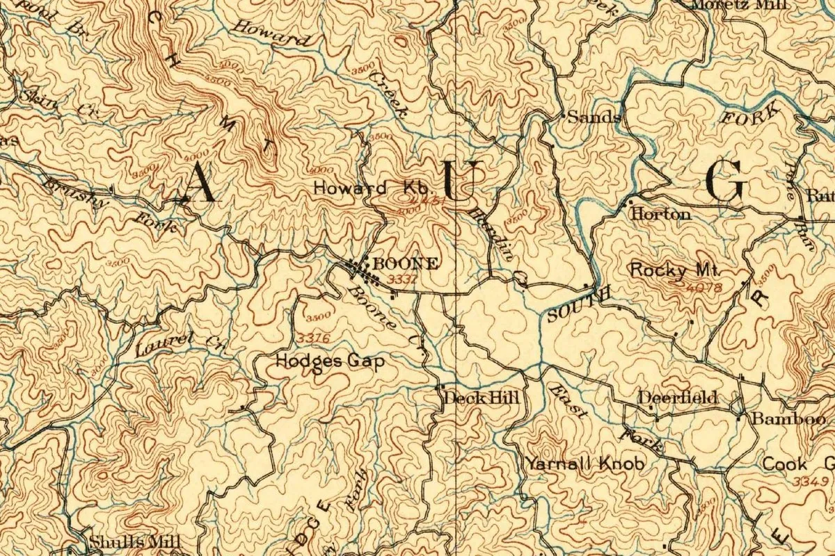
Boone on the 1893 map
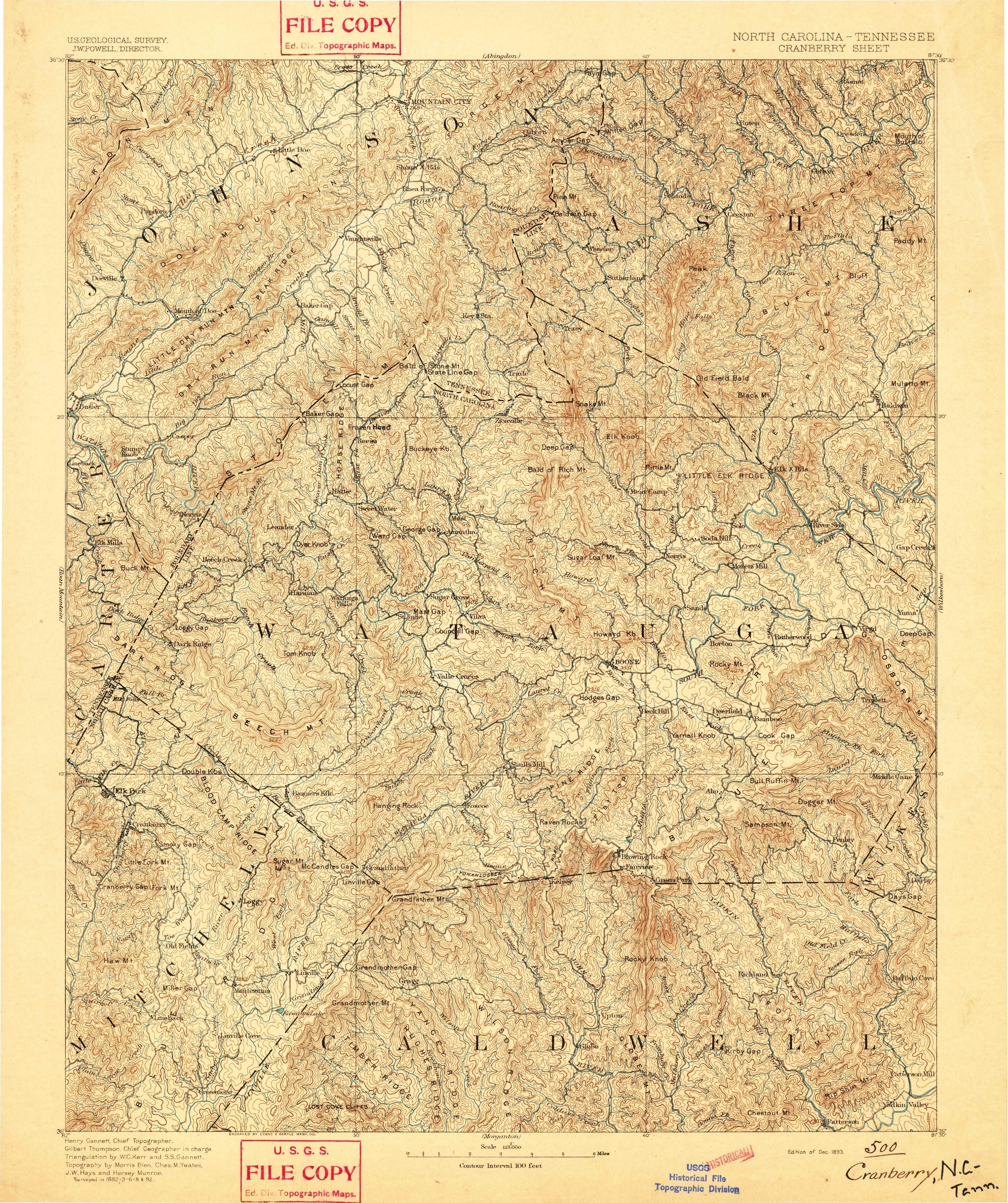
Up top is the Cranberry sheet, which covers a corner of North Carolina and Tennessee, drawn at 1:125,000. J. W. Powell is listed above the map as the Survey’s director. At the bottom, Henry Gannett’s name appears as chief topographer; twelve years later he’d be the one writing up Boone’s name. Gilbert Thompson is chief geographer in charge, W. C. Kerr and S. S. Gannett did the triangulation, and Morris Bien, Chas. M. Yeates, J. W. Hays and Hersey Munroe are credited with the topography. It says “Surveyed in 1882-3-6-8 & 92,” credits the engraving to Evans & Bartle of Washington, and carries the date “Edition of Dec. 1893.”
On the full sheet, Boone sits a little right of center, inside the big spaced letters of WATAUGA. In the crop, BOONE is a short line of dots with the elevation 3332, and Howard Knob rises just above it to 4451. Arthur gives the same heights in his book: the town at 3,332 feet (1,016 m) and Howard’s Knob at 4,451 feet (1,357 m). Boone Creek, Hodges Gap, the South Fork and places like Deerfield and Bamboo fill in around it.
Quick answers
Why is Boone, North Carolina, called Boone?
It’s named for Daniel Boone, according to Henry Gannett. John Preston Arthur, in the county history he published in 1915, says the legislature chose the name because Boone’s old hunting cabin stood a few hundred feet from the courthouse site.
What was Boone, NC, called before?
The post office was Councill’s Store, after Jordan Councill Jr., from 1823 until it was renamed Boone in 1850, according to the town.
Did Daniel Boone live in Boone, NC?
Arthur says Boone and his companions slept in a cabin there on hunting trips. The town calls the connection local lore, strengthened by its first mayor’s monument and trail.
When was Boone incorporated?
At the 1871-72 session of the legislature, according to Arthur. The town says William Lewis Bryan became its first mayor in 1872.
Key dates
- 1823Jordan Councill Jr. opens Councill's Store, the earliest post office in the area.
- 1849The legislature creates Watauga County in January and names commissioners, Councill among them, to lay out its seat.
- 1850Councill agrees to rename the post office Boone.
- 1872The town is chartered, with William Lewis Bryan as its first mayor.
- 1893The Geological Survey publishes the Cranberry sheet, with Boone at 3,332 feet (1,016 m).
- 1905Henry Gannett lists the town among the places named for Daniel Boone.
- 1912A stone and concrete monument goes up on the site of the cabin said to be Boone's.
Things to do in Boone, North Carolina
Daniel Boone Native Gardens
A garden near downtown Boone with more than 200 species of native wildflowers, shrubs and trees, set up so something's blooming through the growing season. The gates are there to keep deer out, not you.
Boone Greenway Trail
A flat, paved or gravel trail beside the New River's South Fork, with three bridges, meadows and woods, a historic dam site with picnic tables, and signs on the area's natural and human history. It works for wheelchairs and strollers.
Turchin Center for the Visual Arts
Appalachian State University's art center on King Street, in the former Boone United Methodist Church building. It opened in 2003, added an east wing in 2008, and has six galleries of changing contemporary exhibitions.
Councill's Store historical marker
A town marker across from Boone Town Hall, on the spot Councill's Store, a post office since 1823, was moved to in the 1880s. It tells how the office took the name Boone in 1850.
Getting there
Open Boone in Google Maps
Opens in a new tab. The pin is the center of Boone in the USGS place-name record.
The closest airports, Amtrak stations and intercity bus stops, measured in a straight line from the center of Boone.
Airports
- Tri-Cities (TRI) Bristol/Johnson/Kingsport 45 mi 72 km
- Asheville Regional (AVL) 73 mi 117 km
- Charlotte/Douglas International (CLT) 80 mi 129 km
Amtrak trains
- Gastonia station (GAS) 71 mi 115 km
- Kannapolis station (KAN) 77 mi 124 km
Intercity buses
- Sunway Charters Boone under 1 mi 0.3 km
- Virginia Breeze, Operated by Dillon's Virginia Breeze · Bristol (Park & Ride) 39 mi 63 km
- Greyhound Newton Citgo 43 mi 69 km
Distances are as the crow flies, not by road. We don't list schedules or fares because they change; check with the airline, Amtrak or the bus company before you go. Official data (FAA commercial service airports (2025), FAA airport locations, Amtrak stations and Intercity Bus Atlas) from the FAA and the U.S. Bureau of Transportation Statistics, checked Nov 18, 2026.
Sponsored
Staying in Boone?
Compare hotels in Boone, North Carolina, on Expedia.
See hotels in BooneWe may earn a commission if you buy through this link. It never changes what we write. Read our affiliate disclosure
Historical Sources & References
- Henry Gannett, The Origin of Certain Place Names in the United States (1905), p. 52. The town in Watauga County “Named for Daniel Boone,” and the Iowa Boone for Captain Boone of the dragoons. Checked against the page image.
- John Preston Arthur, A History of Watauga County (1915), p. 33. The cabin, “Whether Boone actually built it is immaterial,” the 1912 monument, Howard’s Knob at 4,451 feet (1,357 m) and the legislature’s choice of name; p. 141, incorporation in 1871-72, Bryan and 3,332 feet (1,016 m). Checked against the page images.
- Town of Boone, “Historical Markers”. Councill’s Store from 1823, Jordan Councill Jr., the 1849 commissioners, the rename of 1850, Ransom Hayes’s 25 acres (10 ha), Bryan as first mayor in 1872 and the “local lore.”
- Laws of North Carolina, session of 1848-49. Chapters 25 and 26, creating Watauga County and sending commissioners to choose its seat; neither names the town.
- Laws of North Carolina, session of 1850-51, chapter 51. The superior court “at the Court House in Boon” (pp. 119-120). Checked against the page images.
- Daniel Boone Native Gardens; Town of Boone, Greenway Trail; Turchin Center for the Visual Arts (Visit). The details in the things-to-do list.
- U.S. Geological Survey, GNIS feature 1009539. Boone in Watauga County.
- Cranberry sheet, surveyed 1882-92, edition of December 1893. The sheet the map at the top was cropped from.
Sponsored
Put this 1893 map on your wall
The Geological Survey's December 1893 Cranberry sheet, surveyed in 1882-92, with Boone below Howard Knob, is in the public domain. Download the full-size scan for free, then have it printed on canvas with CanvasOnTheCheap.
Print a map on canvasDownload the full-size mapWe may earn a commission if you buy through this link. It never changes what we write. Read our affiliate disclosure
Spot something wrong, or know more? Tell us here. You can also email us or use our contact page. Corrections are noted here with their date, never made silently.