Crestline, Ohio: The Town That Thought It Was on Top
Crestline, Ohio, got its name from a belief about altitude: when it was laid out, people thought it sat on the highest ground in the state. The belief didn’t hold up, but the name did. William Overman’s 1958 book of Ohio town names says that, being a high place, it was “appropriately called” Crestline, and that for many years people thought it was the highest point. Much earlier, William Henry Perrin’s 1881 history of Crawford County kept the old explanation in a description it quotes word for word.
“Hence the name”
Perrin doesn’t make the place sound glamorous. The description he quotes runs:
“It is generally flat about Crestline, and it has something of the appearance of a frontier railroad town, being very muddy, when muddy anywhere, though its general elevation is about the average; indeed, when laid out, it was thought to be the highest point above sea-level in the State, hence the name—Crestline.”
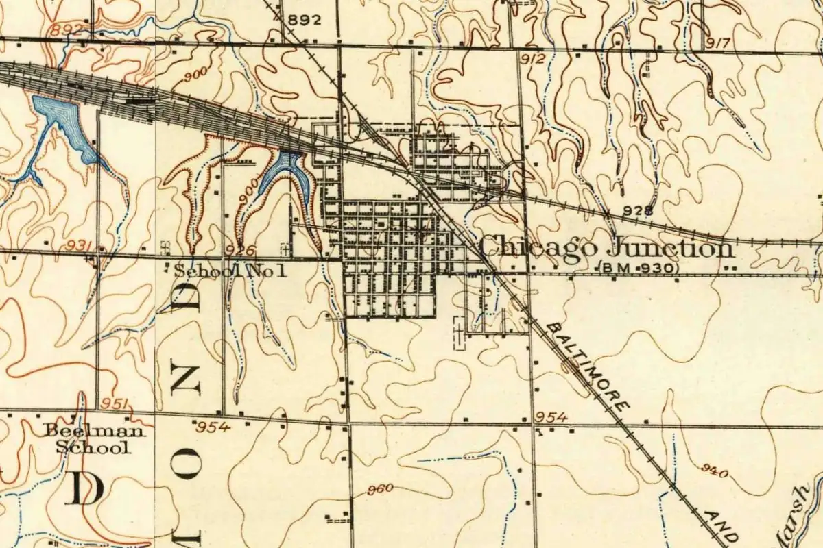
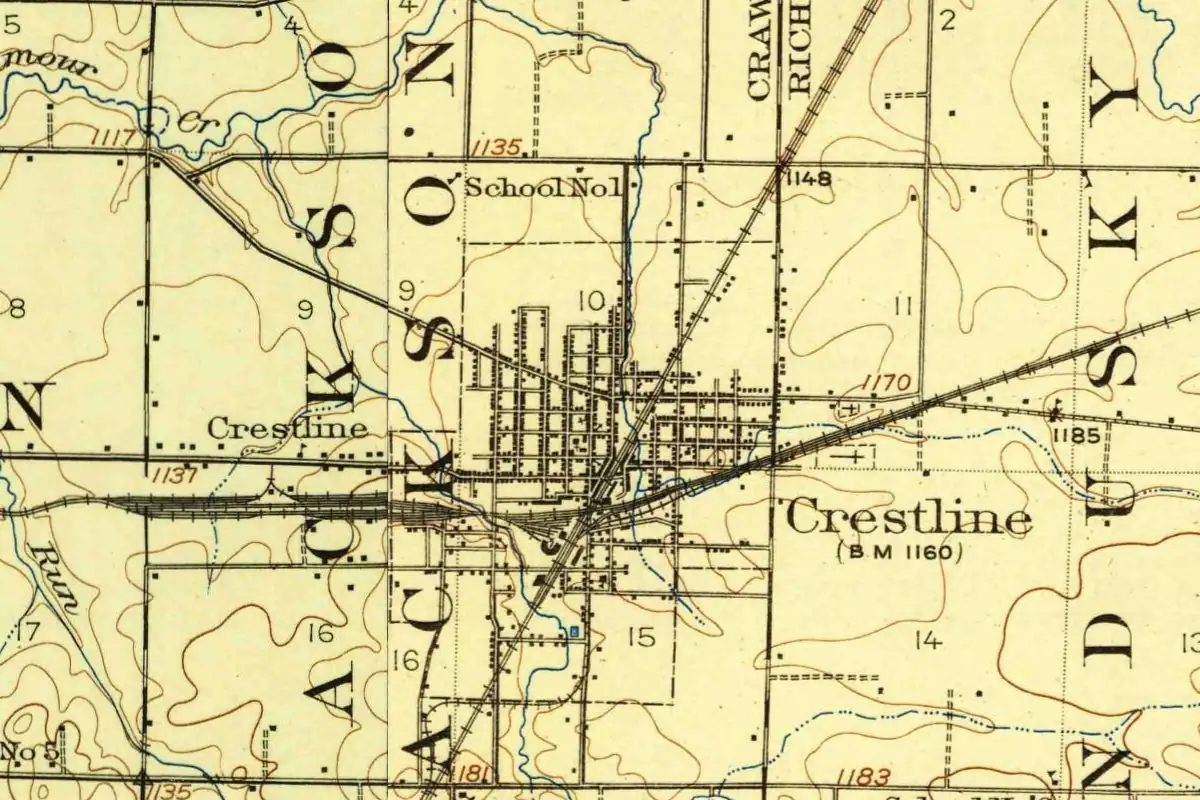
Note the careful wording: “it was thought to be.” By 1881 the county history was already treating the idea as an old belief, not a fact. Elsewhere in the same book, though, Crestline does come out higher than the county seat. Bucyrus stands at 1,009 feet (308 m), Perrin says, but “it is not the highest point in the county, however, Crestline being 1,176 feet above the ocean,” about 358 m. The Geological Survey’s 1915 map labels a bench mark of 1,160 feet (354 m) near the railroad crossing.
Henry Gannett, the Geological Survey’s geographer, put it a little differently in 1905. Crestline, he wrote, was “so called because it occupies the crest line of the middle elevation of the State.” That reads less like a claim to the top of Ohio and more like a ridge running across it.
Livingston and Vernon Station
Before there was a Crestline, there was Livingston. Perrin says Rensellaer Livingston laid it out in 1851, and his plat was filed on February 17 of that year. The depot went by Vernon Station. Then, on December 17, 1852, Jesse R. Straughan’s plat of “the original town of Crestline” was filed on the next section over.
Crestline swallowed its neighbor. Perrin wrote that “doubtless few at the present day remember that there was ever a town in Jackson Township known by the name of Livingston, or Vernon Station.”
Railroads out of a swamp
The book doesn’t hide where the town came from. “The railroads have made Crestline what it is,” Perrin wrote, and before them nobody thought of putting a town there. Only after the trains came did it “rise from the mud of the surrounding swamps,” and men “still in the prime of life” could “remember when the site was a good place to hunt deer.”
Crestline grew up at the crossing of two lines: the Cleveland, Columbus, Cincinnati & Indianapolis, and the Pittsburgh, Fort Wayne & Chicago. Perrin, in his chapter on the railroads, dates the opening of the road from Pittsburgh to Crestline to April 11, 1853. The town had 1,455 people in 1860 and 2,787 by 1880. The 1915 map shows you the lines still meeting in the middle of the grid.
If you’re keeping track, Ohio has another town named for height, Akron, whose name comes from a Greek word for “high.”
Quick answers
Why is it called Crestline, Ohio?
A description quoted in Perrin’s 1881 county history says that when the town was laid out, “it was thought to be the highest point above sea-level in the State, hence the name.” Gannett (1905) says it sits on “the crest line of the middle elevation of the State.”
Is Crestline the highest point in Ohio?
No source we read says it is. The 1881 history says only that it “was thought to be,” and puts Crestline at 1,176 feet (358 m), higher than Bucyrus.
Did Crestline have another name first?
The first plat, filed in 1851, was the town of Livingston, and the station was called Vernon Station. The Crestline plat followed in December 1852.
Key dates
- 1851February 17: Rensellaer Livingston's plat of the town of Livingston is filed.
- 1852December 17: Jesse R. Straughan's plat of the original town of Crestline is filed.
- 1853April 11: the railroad opens from Pittsburgh to Crestline.
- 1880The census counts 2,787 people in Crestline.
Getting there
Open Crestline in Google Maps
Opens in a new tab. The pin is the center of Crestline in the USGS place-name record.
The closest airports, Amtrak stations and intercity bus stops, measured in a straight line from the center of Crestline.
Airports
- John Glenn Columbus International (CMH) 55 mi 89 km
- Cleveland-Hopkins International (CLE) 63 mi 101 km
Amtrak trains
- Sandusky station (SKY) 45 mi 73 km
- Elyria station (ELY) 52 mi 84 km
Intercity buses
- Greyhound Mansfield Bus Stop 13 mi 22 km
- Barons Bus Lines Mansfield 13 mi 22 km
- GoBus Mansfield (E), OH 13 mi 22 km
Distances are as the crow flies, not by road. We don't list schedules or fares because they change; check with the airline, Amtrak or the bus company before you go. Official data (FAA commercial service airports (2025), FAA airport locations, Amtrak stations and Intercity Bus Atlas) from the FAA and the U.S. Bureau of Transportation Statistics, checked Nov 6, 2026.
Sponsored
Staying in Crestline?
Compare hotels in Crestline, Ohio, on Expedia.
See hotels in CrestlineWe may earn a commission if you buy through this link. It never changes what we write. Read our affiliate disclosure
Historical Sources & References
- William Henry Perrin, ed., History of Crawford County and Ohio (1881), pp. 181, 269, 492-494. The quoted description ending “hence the name—Crestline”; the plats of Livingston (February 17, 1851) and Crestline (December 17, 1852); Vernon Station; the railroads, the swamps and the deer; the April 11, 1853, opening from Pittsburgh (p. 269); the elevations of Bucyrus and Crestline; population figures for 1860 to 1880.
- Henry Gannett, The Origin of Certain Place Names in the United States (1905), p. 95. Crestline, “so called because it occupies the crest line of the middle elevation of the State.”
- William D. Overman, Ohio Town Names (1958). Crestline, first called Livingstone, renamed when the plat was recorded in 1852; a high place, “appropriately called” Crestline, and for many years thought to be the highest point (seen only as search excerpts; the scan is a library loan).
- GNIS feature 1061006 (U.S. Geological Survey). The gazetteer record for Crestline, in Crawford County, with the note “Incorporated 1858.”
Spot something wrong, or know more? Tell us here. You can also email us or use our contact page. Corrections are noted here with their date, never made silently.