Put-in-Bay, Ohio: Storm Shelter, Perry or a Pudding Bag?
Nobody has settled it. A 2015 National Park Service register form says Put-in-Bay first meant the harbor where ships would 'put in' to wait out Lake Erie storms. Theresa Thorndale wrote in 1898 that most people credited Perry's squadron putting into the bay before the 1813 battle, while a historian called it a corruption of 'Pudding Bay.'
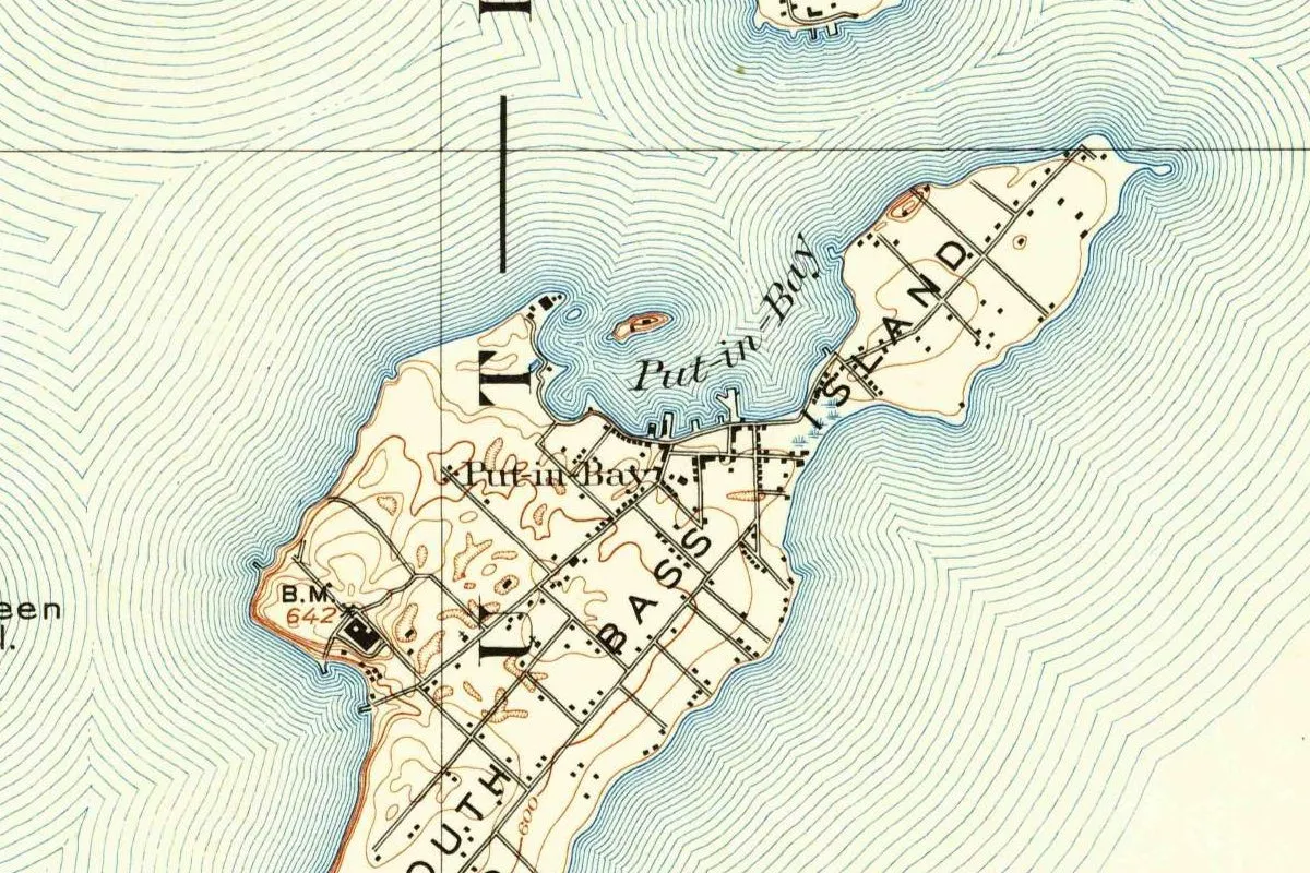
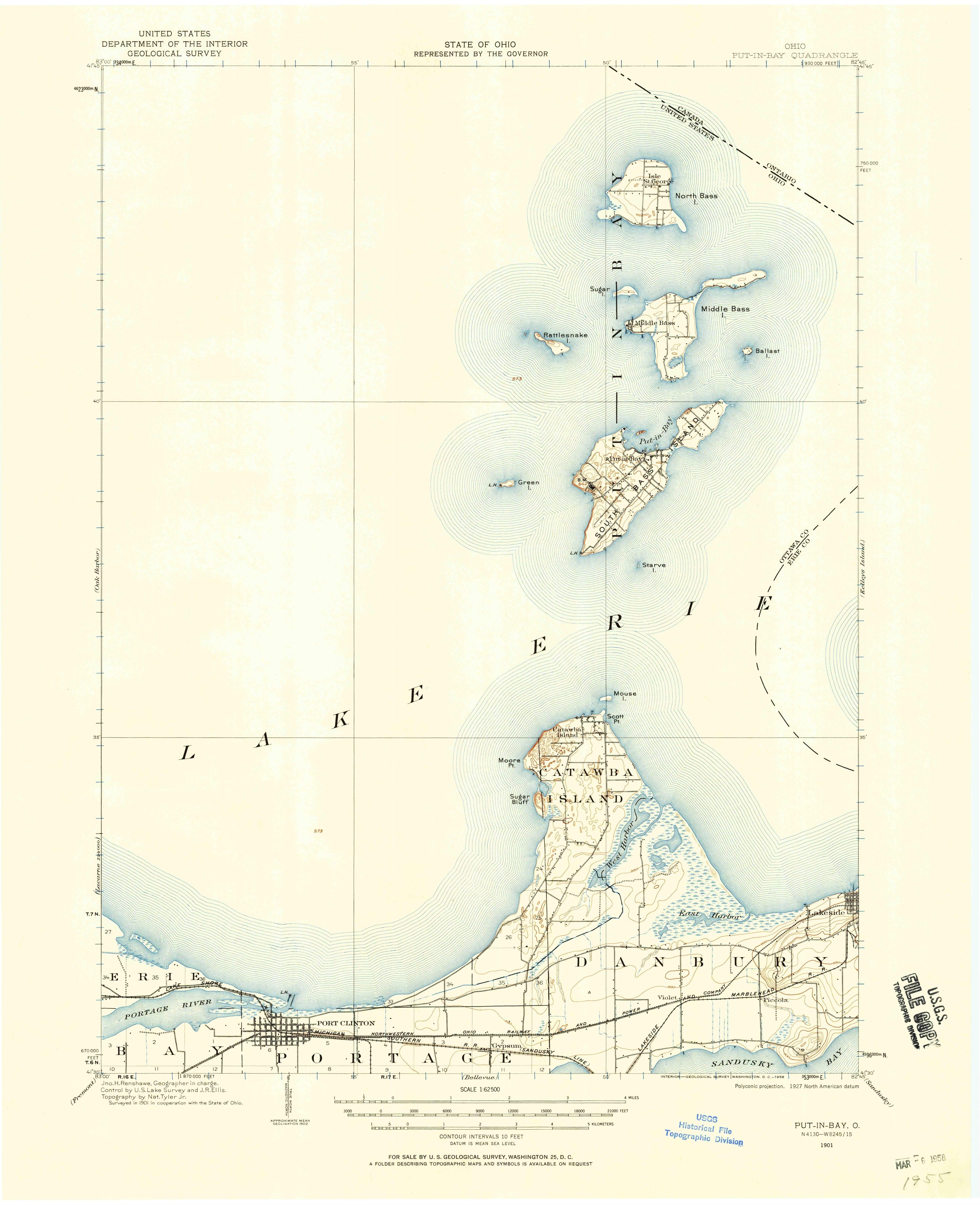
Put-in-Bay, Ohio, took its name from the bay on South Bass Island, but nobody agrees why the bay was called that, and the stories go back at least to 1898. On the map at the top of this page, you’ll find the words “Put-in-Bay” printed twice, once across the water and once beside the little village on its shore. The water had the name first, the National Park Service says.
A harbor before a town
The National Park Service put it plainly in a 2015 register form for Perry’s Victory and International Peace Memorial: “The name Put-in-Bay originally referred only to the harbor.” The same form says the township of Put-in-Bay wasn’t organized until 1830. The earliest recorded title to South Bass Island dates from 1792, there’s evidence of a non-Indian resident in 1810, and whatever settlement existed before the War of 1812 was small, “if one existed at all.”
Theresa Thorndale, whose souvenir book on the Lake Erie islands came out in Sandusky in 1898, describes the bay as a sheet of water between two points of land, East Point and Peach Point. “In the early history of lake navigation,” she wrote, “this bay was known as a harbor of refuge.” The island itself, she adds, was once known as “Ross Island.”
Three stories, and no winner
Where the name came from is the part nobody has pinned down. Thorndale said so in 1898:
“As to the origin of its present name there is a division of opinion. It is stated on the authority of a historian, that Put-in-Bay is a corruption of ‘Pudding Bay,’ an appellation given it by early navigators.” (Thorndale, p. 12)
She doesn’t name the historian. The other camp, she wrote, said the name came from the American squadron, whose ships “put into the wide and ample bay” before the Battle of Lake Erie and lay there for several days. “The latter theory is the one generally accepted,” she concluded.
The Park Service’s 2015 form goes a different way. It ties the name to the weather and leaves Perry out of its explanation: the harbor was where ships “would stop, or ‘put in’ to wait out the fierce Lake Erie storms.” And the island’s visitors bureau, answering the question “What does Put-in-Bay Mean?”, lists three explanations: a ceremony Native Americans held at the bay, the shelter the bay gave boaters, and the idea that the harbor looked like a “pudding bag.” A pudding bag isn’t the same as Thorndale’s Pudding Bay, and none of these sources explains the other’s version.
What Perry’s fleet did there
What the squadron did at the bay isn’t in dispute. The register form says Commodore Oliver Hazard Perry’s ships waited at Put-in-Bay, on the northeast side of the island, while lookouts on nearby Gibraltar Island watched for the British. The battle was fought on September 10, 1813, about eight miles (13 km) northwest of South Bass Island. Two days later the crews of both fleets buried three American and three British officers on the shore, at what is now Perry Park in the village. A replica of one of that battle’s ships, Perry’s flagship Niagara, docks farther east on the lake, at Erie, Pennsylvania.
Five years after the battle, the traveler William Darby sailed by on a trip from New York to Detroit and wrote it up in a book published in 1819. On page 185 he calls the place “Edward’s clearing, or Put-in-bay,” and the harbor “decidedly the best in all lake Erie, and dear to the American heart, from the events of last war.” The register form, for its part, says Judge Ogden Edwards of Connecticut bought the three Bass Islands in 1812, though Darby doesn’t say which Edwards he meant. Darby shows the name was in use by 1818. He doesn’t say where it came from, and he can’t settle whether it was older than the battle.
The village and the column
The register form says Ottawa County, the Ohio county that holds Put-in-Bay, was organized in 1840 and named after a local Algonquin tribe. The memorial column that rises over the village is 352 feet (107 m) tall; the form says its cornerstone was laid in 1913, and bronze plaques at its doors date to the dedication ceremonies of 1931.
Put-in-Bay on the 1901 map
The map at the top comes from the Geological Survey’s Put-in-Bay sheet, surveyed in 1901 in cooperation with the State of Ohio, with topography by Nat. Tyler Jr. and control by the U.S. Lake Survey. The copy scanned here isn’t the first printing: its margin carries the printer’s line “INTERIOR—GEOLOGICAL SURVEY, WASHINGTON, D. C.—1958” and a 1927 datum note, so it’s a 1958 printing of the 1901 survey. On the full sheet, South Bass Island sits in the upper middle, with the Bass Islands chain to the north and the Canadian border cutting the top corner. In the crop you’ll see “Put-in-Bay” written across the bay, with a small island inside it, “Put-in-Bay” again next to the village streets on the shore, the words “South Bass Island,” and bench mark 642 on the western shore.
Quick answers
Why is it called Put-in-Bay?
Nobody knows for sure. A 2015 Park Service register form says ships would “put in” to the harbor to wait out storms; Theresa Thorndale wrote in 1898 that most people credited Perry’s squadron putting into the bay before the 1813 battle.
Is Put-in-Bay named after Perry?
No source here says it’s named for Perry himself. Thorndale wrote in 1898 that the generally accepted story was that his squadron put into the bay before the battle; the Park Service’s register form ties the name to ships waiting out storms.
What is the “Pudding Bay” story?
Thorndale wrote that a historian, whom she didn’t name, called Put-in-Bay “a corruption of ‘Pudding Bay,’” a name early navigators gave it. The island’s visitors bureau tells a related story about a harbor shaped like a “pudding bag.”
What was South Bass Island called before?
Thorndale wrote in 1898 that it was once known as “Ross Island.” The name Put-in-Bay, the Park Service says, at first meant only the harbor.
Key dates
- 1792The earliest recorded title to South Bass Island dates from this year, the Park Service register form says.
- 1812Judge Ogden Edwards of Connecticut buys the three Bass Islands.
- 1813Perry's squadron waits at Put-in-Bay and wins the Battle of Lake Erie on September 10.
- 1818William Darby sails past "Edward's clearing, or Put-in-bay," and calls it the best harbor on Lake Erie.
- 1830The township of Put-in-Bay is organized.
- 1898Theresa Thorndale writes that there is "a division of opinion" on the origin of the name.
- 1901The Geological Survey surveys the Put-in-Bay sheet with the State of Ohio.
- 1913The cornerstone of Perry's memorial column is laid; the memorial is dedicated in 1931.
Things to do in Put-in-Bay, Ohio
Lake Erie Islands Historical Society Museum
A downtown museum on the history of the islands, with exhibits on wine making, Put-in-Bay's Victorian hotels, the ice industry, the island road races and the Ford Tri-Motor airplane known as the Tin Goose.
South Bass Island State Park
A 33-acre (13 ha) state park on the west side of the island, above a rocky Lake Erie shoreline, where you can see the remains of Hotel Victory, one of the country's largest hotels in 1892, which burned in 1919.
South Bass Island Lighthouse
A lighthouse listed on the National Register of Historic Places, which the Park Service calls the only university-owned lighthouse in the country; Ohio Sea Grant's tours include a climb to the top of the tower.
Scheeff East Point Preserve
An 8.8-acre (3.6 ha) preserve with a walking path around its rocky shore, habitat for the Lake Erie watersnake and migrating birds, with shoreline fishing and access for kayaks.
Getting there
Open Put-in-Bay in Google Maps
Opens in a new tab. The pin is the center of Put-in-Bay in the USGS place-name record.
The closest airports, Amtrak stations and intercity bus stops, measured in a straight line from the center of Put-in-Bay.
Airports
- Detroit Metro Wayne County (DTW) 47 mi 76 km
- Eugene F Kranz Toledo Express (TOL) 51 mi 82 km
Amtrak trains
- Sandusky station (SKY) 16 mi 25 km
- Toledo station (TOL) 37 mi 60 km
Intercity buses
- GoBus Port Clinton 11 mi 18 km
- Greyhound Sandusky Bus Stop 16 mi 25 km
- Barons Bus Lines Toledo (Amtrak) 37 mi 60 km
Distances are as the crow flies, not by road. We don't list schedules or fares because they change; check with the airline, Amtrak or the bus company before you go. Official data (FAA commercial service airports (2025), FAA airport locations, Amtrak stations and Intercity Bus Atlas) from the FAA and the U.S. Bureau of Transportation Statistics, checked Nov 18, 2026.
Sponsored
Staying in Put-in-Bay?
Compare hotels in Put-in-Bay, Ohio, on Expedia.
See hotels in Put-in-BayWe may earn a commission if you buy through this link. It never changes what we write. Read our affiliate disclosure
Historical Sources & References
- National Park Service, National Register form for Perry’s Victory and International Peace Memorial (2014-2015), Section 8, pp. 57-58. The name first meaning only the harbor, where ships would “put in” to wait out storms; the township of 1830, the title of 1792 and the resident of 1810; the squadron at the bay, the battle of September 10, 1813, and the burials of September 12; Ogden Edwards’s purchase of 1812; Ottawa County in 1840; the column, the cornerstone of 1913 and the dedication of 1931.
- Theresa Thorndale, Sketches and Stories of the Lake Erie Islands (1898), pp. 12-13. The “division of opinion,” Pudding Bay, the squadron theory “generally accepted,” Ross Island, East Point and Peach Point, and the harbor of refuge. Checked against the page images.
- William Darby, A Tour from the City of New-York, to Detroit (1819), p. 185. “Edward’s clearing, or Put-in-bay,” the best harbor on Lake Erie, and Perry’s departure from it on September 10, 1813. Checked against the page image.
- Put-in-Bay Visitors & Convention Bureau. The FAQ “What does Put-in-Bay Mean?” with three explanations, among them the “pudding bag.”
- Lake Erie Islands Historical Society; Park Service, Nearby Attractions; Ohio Sea Grant, South Bass Island Lighthouse; Scheeff East Point Preserve. The details in the things-to-do list.
- U.S. Geological Survey, GNIS feature 1077351. The village’s entry in the national names database, with Ottawa County and its coordinates.
- Put-in-Bay sheet, surveyed 1901, printed 1958. The sheet the map at the top was cropped from, with Jno. H. Renshawe as geographer in charge and the 1958 printer’s line in the margin.
Sponsored
Put this 1901 map on your wall
The Put-in-Bay quadrangle, surveyed in 1901 by the Geological Survey with the State of Ohio (this copy was printed in 1958), shows the name on both the bay and the village, and is in the public domain. Download the full-size scan for free, then have it printed on canvas with CanvasOnTheCheap.
Print a map on canvasDownload the full-size mapWe may earn a commission if you buy through this link. It never changes what we write. Read our affiliate disclosure
Spot something wrong, or know more? Tell us here. You can also email us or use our contact page. Corrections are noted here with their date, never made silently.