Spearfish, South Dakota: Who Speared the Fish?
Spearfish takes its name from Spearfish Creek, and the creek is named for spearing fish in its waters. Sources differ on who did the spearing: the city credits Native Americans, a regional water system names the Lakota and other groups, and Visit Spearfish also tells a story about gold rush miners.
Spearfish, South Dakota, is named for Spearfish Creek, where people once speared fish, but the sources don’t agree on who those people were. The creek part isn’t in doubt. An 1899 history of the Black Hills says the town was laid out “on the banks of the beautiful stream from which it derived its name.”
The creek came first
Annie D. Tallent published The Black Hills; or, The Last Hunting Ground of the Dakotahs in St. Louis in 1899. She writes that a colony from Montana reached the valley on May 20, 1876, and that rival claimants to the town site settled their quarrel by forming one town-site company. “Accordingly on the 29th of May, 1876, Spearfish was laid out on the banks of the beautiful stream from which it derived its name,” she says. H. S. Burke surveyed and platted the site “with the aid of the traditional pocket compass.”
Black Hills State University’s library, marking the town’s 150th year, gives the same date for the platting, May 29, 1876, and adds that incorporation came in 1888. Tallent names the stream but doesn’t say how it got its name.
Who speared the fish
That’s where the sources split, and you’ll get a different answer depending on whom you ask. The City of Spearfish, in a short history on its police department’s page, says the city “is named after the creek that runs through it. The Native Americans that used to spear fish in the clear waters gave the creek its name.”
The Western Dakota Regional Water System is more specific. It says the city “takes its striking name from the practice of the Lakota and other groups who ‘speared’ fish in the fast-flowing waters of Spearfish Creek.”
Visit Spearfish, the town’s tourism office, admits there’s no single answer. “One thing some can’t agree on is how Spearfish got its name,” Kory Otterberg wrote on its blog in 2017. “Many believed that the name started from the Native American people. These people would take spears to the river (now Spearfish Creek) and fish.” The second story, he says, is about gold rush miners, who needed to feed themselves and their men while they looked for riches in the hills, and found Spearfish Creek “a perfect spot for spearfishing.” “Each story has the same theme ‘Spearfish Creek provided an opportunity to fish’ but they differ over the details,” Otterberg wrote.
Fish are behind other place names, too. Whitefish, Montana, is named for a lake that took its name from the whitefish caught at its outlet. And in the story of Napa, California, the anthropologist A. L. Kroeber pointed to a Pomo word for a fish harpoon’s points as a possible lead, while saying there was “no distinct evidence” that it was the source of the name.
The Queen City
Spearfish has a nickname, and Tallent knew where it came from. At the town’s first Fourth of July celebration, in 1878, Judge Bradley welcomed the crowd “to Spearfish, ‘The Queen City of the Hills.’” Tallent wrote that the title “has clung to Spearfish since that time.”
Later writers tell it differently. The water system says the town was “originally called Queen City when it was established in 1876,” and Visit Spearfish says the name fits because the peaks around town, with an opening to the north, “create the illusion of a queen’s tiara.”
Spearfish grew quickly in its first years. The city says that “by 1890 the population of Spearfish had grown to 671.” In 1896, Congress made a first appropriation for a fish culture station at Spearfish, according to the U.S. Fish & Wildlife Service, which runs it today as the D.C. Booth Historic National Fish Hatchery.
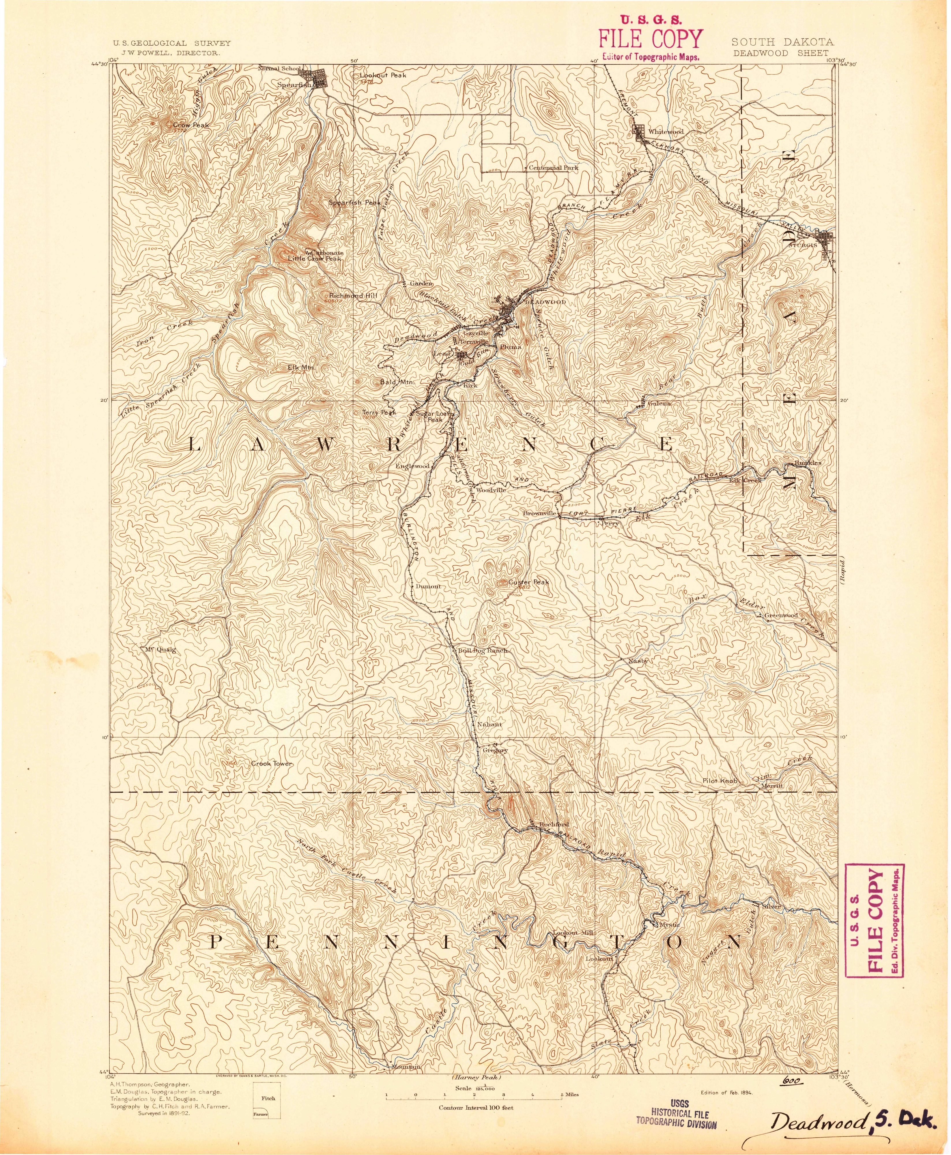
Spearfish on the 1894 map
The map at the top of this page comes from the Geological Survey’s Deadwood sheet at 1:125,000, in its “Edition of Feb. 1894.” The margin credits A. H. Thompson as geographer, E. M. Douglas as topographer in charge, and topography by C. H. Fitch and R. A. Farmer, “Surveyed in 1891-92.” The sheet is named for Deadwood, which sits near the middle of its upper half. Spearfish is up against the top edge, left of center, in the northern Black Hills of South Dakota.
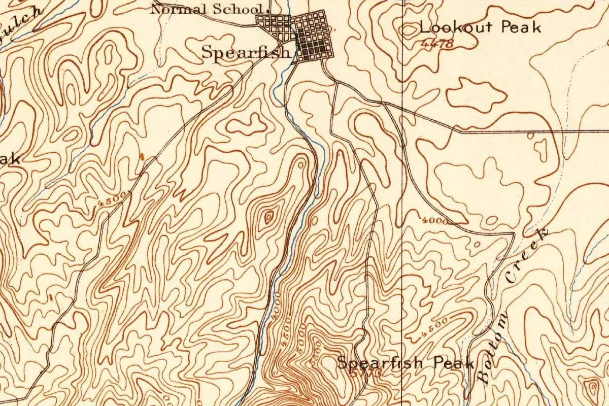
In this detail, you can see Spearfish lettered beside a small town grid, with the words “Normal School” next to it. Lookout Peak, marked 4478, and Spearfish Peak rise nearby. The contour lines are drawn every 100 feet (30 m).
Quick answers
How did Spearfish, South Dakota, get its name?
From Spearfish Creek. The town was laid out on the creek in 1876, and the creek’s name comes from people spearing fish in it.
Who speared fish in Spearfish Creek?
The sources differ. The city says Native Americans, the regional water system says the Lakota and other groups, and Visit Spearfish tells a second story about gold rush miners.
Why is Spearfish called the Queen City?
Tallent traced it to Judge Bradley’s welcome on July 4, 1878, to “The Queen City of the Hills.” Visit Spearfish says the peaks around town look like a queen’s tiara.
Key dates
- 1876A colony from Montana arrives in the valley on May 20, and Spearfish is laid out on the creek on May 29.
- 1878At the town's first Fourth of July celebration, Judge Bradley welcomes visitors to "The Queen City of the Hills."
- 1888Spearfish is incorporated.
- 1890The population reaches 671, according to the city.
- 1894The Geological Survey issues its Deadwood sheet, which shows Spearfish, surveyed in 1891-92.
- 1896Congress makes a first appropriation for a fish culture station at Spearfish, today's D.C. Booth hatchery.
Things to do in Spearfish, South Dakota
D.C. Booth Historic National Fish Hatchery
The town's federal fish hatchery, once named for Spearfish, founded in 1896 and still raising trout today. You can walk through its old buildings and museum, and it keeps the national archives of fish culture. The site is listed on the National Register of Historic Places.
Spearfish Canyon
The canyon Spearfish Creek has cut through limestone, with cliffs as high as 1,000 feet (305 m) and waterfalls along the way. A road runs through it, and Visit Spearfish rates the drive among the best in the area.
High Plains Western Heritage Center
A museum devoted to the West's pioneers and legends, with over 20,000 square feet (about 1,860 m²) of exhibits. In its Cowboy Hall, you'll find the saddle Calvin Coolidge used when he dedicated Mount Rushmore.
Spearfish City Park
The town's main park, with picnic shelters and a band shell. Spearfish Creek loops through it beside the Rec Path, a walking and biking trail of more than 7.5 miles (12 km) across town.
Getting there
Open Spearfish in Google Maps
Opens in a new tab. The pin is the center of Spearfish in the USGS place-name record.
The closest airports, Amtrak stations and intercity bus stops, measured in a straight line from the center of Spearfish.
Airports
- Rapid City Regional (RAP) 50 mi 81 km
- Northeast Wyoming Regional (GCC) Gillette 83 mi 134 km
Intercity buses
- Jefferson Lines Spearfish 2 mi 3 km
Distances are as the crow flies, not by road. We don't list schedules or fares because they change; check with the airline, Amtrak or the bus company before you go. Official data (FAA commercial service airports (2025), FAA airport locations, Amtrak stations and Intercity Bus Atlas) from the FAA and the U.S. Bureau of Transportation Statistics, checked Nov 18, 2026.
Sponsored
Staying in Spearfish?
Compare hotels in Spearfish, South Dakota, on Expedia.
See hotels in SpearfishWe may earn a commission if you buy through this link. It never changes what we write. Read our affiliate disclosure
Historical Sources & References
- City of Spearfish, Police Department, “History”. The city founded in 1876, 671 people by 1890, and the creek named by “the Native Americans that used to spear fish.”
- Kory Otterberg, “What’s in a name?” Visit Spearfish (2017). The two stories of the name and the tiara of peaks.
- Western Dakota Regional Water System, “Spearfish: planning ahead”. The Lakota and other groups who speared fish, and Queen City.
- Annie D. Tallent, The Black Hills; or, The Last Hunting Ground of the Dakotahs (1899), pp. 541-542. The town laid out on May 29, 1876, on the stream “from which it derived its name”; on p. 565, the Queen City of 1878. Checked against the page images.
- Black Hills State University Library, “Remembering Spearfish”. The platting of May 29, 1876, and incorporation in 1888.
- D.C. Booth Historic National Fish Hatchery, Spearfish Canyon, High Plains Western Heritage Center and Spearfish City Park. The places listed above, and the hatchery’s date.
- Spearfish’s GNIS entry, feature 1262476 (U.S. Geological Survey). The city’s listing as a populated place in Lawrence County, with its coordinates.
- U.S. Geological Survey, Deadwood sheet (February 1894). The 1:125,000 sheet the map at the top was cropped from.
Sponsored
Put this 1894 map on your wall
The Geological Survey's 1894 Deadwood sheet, surveyed in 1891-92, with Spearfish and its Normal School at the top edge, is in the public domain. Download the full-size scan for free, then have it printed on canvas with CanvasOnTheCheap.
Print a map on canvasDownload the full-size mapWe may earn a commission if you buy through this link. It never changes what we write. Read our affiliate disclosure
Spot something wrong, or know more? Tell us here. You can also email us or use our contact page. Corrections are noted here with their date, never made silently.