Oak Ridge, Tennessee: How the Secret City Got Its Name
Oak Ridge is named for Black Oak Ridge, where the wartime town was being built. In July 1943, Robert C. Blair of the Clinton Engineer Works asked employees for name suggestions. Officials chose Oak Ridge for the location and, in the words of a 1950 history, because "its rural connotation held outside curiosity to a minimum."
Oak Ridge, Tennessee, had no name until the summer of 1943, when the Army asked its own employees for ideas and picked one that sounded like farm country. That was the point. The town was being built to house the workers of a top-secret project, and the less the name said about it, the better.
The farms and villages that came first
Before the town, there were farming communities in the valleys. George O. Robinson’s The Oak Ridge Story, published in 1950, says the government’s tract covered 92 square miles (238 km²), 58,800 acres in Anderson and Roane counties, and that Scarboro, Robertsville and Wheat had consolidated schools for around 1,100 pupils. Elza, Edgemoor, Blair and Solway stood around the edges.
Wheat had been renamed once already. The National Park Service says the community of Bald Hill became Wheat in 1881, after Henry Franklin Wheat, its first postmaster. It had three stores, a Masonic lodge, a post office and several churches.
In 1942, the Army Corps of Engineers bought the land, an estimated 60,000 acres by the Park Service’s count. On December 1, 1942, the Park Service says, Manhattan Project administrators ordered the displacement of 3,000 people, including the 1,000 residents of Wheat, many of whom had only weeks to leave. The Tennessee Historical Society puts the number removed at about 4,000. In 1947, the Atomic Energy Commission began letting former Wheat residents back onto the reservation for their annual homecomings.
A town with no name
The Park Service says uranium enrichment began here in the fall of 1942, and by the summer of 1943 the site had become the administrative headquarters of the Manhattan Project. Robinson calls the Army’s installation the Clinton Engineer Works.
Vincent C. Jones, writing the Army’s official history of the Manhattan Project in 1985, says clusters of buildings were going up on “the slopes of Black Oak Ridge” in the spring of 1943. Robinson says the first family moved into a trailer on July 13, 1943, and the first Cemesto house was occupied on July 27.
Until then, as Jones puts it, “the town had no name until Marshall’s executive officer, Lt. Col. Robert C. Blair, requested employee suggestions.” Robinson tells it the same way, though he calls Blair a colonel “then in charge of Clinton Engineer Works,” and he dates the request to the same month, July 1943.
Why Oak Ridge
Robinson gives two reasons. He says “Oak Ridge was chosen because the site on which the town was being built was known as Black Oak Ridge and its rural connotation held outside curiosity to a minimum.” Jones, writing 35 years later, says district officials chose it as “appropriate because of the location and because ‘its rural connotation held outside curiosity to a minimum.’”
You’ll notice the wording is nearly the same. That’s because Jones’s footnote says the quoted words come from Robinson’s book, so on the rural reason the Army history is repeating Robinson. Neither book names the employee who first suggested Oak Ridge.
The old place names didn’t vanish, either. Robinson says the settlements around the edge of the reservation, Elza, Edgemoor, Blair and Solway, along with Oliver Springs, became “especially familiar designations in the Atomic Age.” He says barriers were set up at those points and at two others, the Gallaher and White Wing entrances, so the old village names became the names of the gates you had to pass to get in.
The Secret City grows up
The disguise covered a lot of people and a lot of industry. The Park Service says three huge uranium enrichment plants went up here, and that the uranium enriched at Oak Ridge went into Little Boy, the bomb dropped on Hiroshima. It says the town was planned for 13,000 residents and grew to more than 75,000 during the war, which made it the fifth-largest city in Tennessee during the war. The Park Service calls it the “Secret City.”
Other wartime and government towns got their names in other ways. Henderson, Nevada, began as Basic Townsite, housing for a wartime magnesium plant, and took the name of former Senator Charles B. Henderson in 1944. Boulder City, Nevada, was named for the Boulder Canyon Project, even though the dam was built in Black Canyon.
After the war, Oak Ridge went from a temporary military town to a self-governing city, incorporated in 1959, according to the Park Service. Today the city says it lies about 22 miles (35 km) northwest of Knoxville and covers parts of both Anderson and Roane counties. Robinson, in 1950, put the reservation 18 miles (29 km) west and northwest of Knoxville.
Oak Ridge on the 1952 map
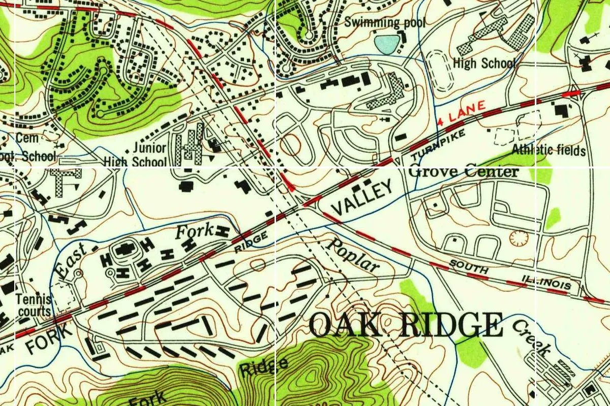
The map at the top of this page comes from the Windrock quadrangle, which the Tennessee Valley Authority revised in 1952 from aerial photographs. This copy was printed in 1954, according to the printer’s line in its margin. Where the city now stands, the 1936 edition of the same sheet shows Robertsville and the open valley.
On the full 1952 sheet, OAK RIDGE is lettered near the bottom right corner, the label “U.S. Atomic Energy Commission (Oak Ridge Area)” runs across the bottom, and the ridge just to the northwest is marked “Black Oak.” In this detail you can see the town’s name, the four-lane turnpike along the valley, Grove Center, the schools and rows of H-shaped buildings. The thin white lines that cross the image come from the scan, not the map.
Quick answers
Why is it called Oak Ridge?
For Black Oak Ridge, where the town was being built, according to George O. Robinson’s 1950 history. He adds that it was chosen because “its rural connotation held outside curiosity to a minimum,” words the Army’s 1985 history quotes from his book.
Who named Oak Ridge, Tennessee?
Robert C. Blair asked employees for suggestions in July 1943, according to George O. Robinson’s 1950 history, and district officials picked Oak Ridge, according to the Army’s 1985 history by Vincent C. Jones.
What was Oak Ridge called before?
The town had no name before 1943, Jones says. The project was the Clinton Engineer Works, and the land had been home to communities such as Scarboro, Robertsville and Wheat.
Key dates
- 1881The farming community of Bald Hill is renamed Wheat, for its first postmaster, according to the National Park Service.
- 1942The Army Corps of Engineers buys the land, and on December 1 the displacement of about 3,000 people, including Wheat's 1,000 residents, is ordered.
- 1943The first families move in during July, and the same month Robert C. Blair asks employees to suggest a name; Oak Ridge is chosen.
- 1947The Atomic Energy Commission lets former Wheat residents back onto the reservation for their homecomings.
- 1952The Tennessee Valley Authority revises the Windrock map, which labels the town OAK RIDGE.
- 1959Oak Ridge incorporates as a self-governing city.
Things to do in Oak Ridge, Tennessee
Manhattan Project National Historical Park Visitor Center
The National Park Service's Oak Ridge visitor center, inside the Children's Museum of Oak Ridge, where you can learn about the Manhattan Project and pick up a junior ranger book or a passport stamp.
K-25 Overlook and Visitor Center
An overlook on the site of Happy Valley, the workers' community, with a view of the K-25 site. The Park Service says K-25 was the largest building in the world during the Manhattan Project, over half a mile (0.8 km) long, with more than 10,000 workers in 1945.
American Museum of Science and Energy
A science museum that tells the story of the advances in science and engineering in Oak Ridge since the first days of the Manhattan Project, with interactive exhibits and programs.
Wheat Community Wayside
A Park Service exhibit panel on the Wheat Greenway, in front of the George Jones Memorial Baptist Church, about the farming community of Wheat, once called Bald Hill, whose 1,000 residents were displaced in 1942.
Getting there
Open Oak Ridge in Google Maps
Opens in a new tab. The pin is the center of Oak Ridge in the USGS place-name record.
The closest airports, Amtrak stations and intercity bus stops, measured in a straight line from the center of Oak Ridge.
Airports
- McGhee Tyson (TYS) Alcoa 21 mi 33 km
- Lovell Field (CHA) Chattanooga 85 mi 137 km
- Nashville International (BNA) 135 mi 217 km
Intercity buses
- Greyhound Knoxville Area Transit Bus Stop 22 mi 35 km
Distances are as the crow flies, not by road. We don't list schedules or fares because they change; check with the airline, Amtrak or the bus company before you go. Official data (FAA commercial service airports (2025), FAA airport locations, Amtrak stations and Intercity Bus Atlas) from the FAA and the U.S. Bureau of Transportation Statistics, checked Nov 18, 2026.
Sponsored
Staying in Oak Ridge?
Compare hotels in Oak Ridge, Tennessee, on Expedia.
See hotels in Oak RidgeWe may earn a commission if you buy through this link. It never changes what we write. Read our affiliate disclosure
Historical Sources & References
- Vincent C. Jones, Manhattan: The Army and the Atomic Bomb (1985), p. 443. The slopes of Black Oak Ridge, the town with no name, Blair’s request and the reasons for the choice. Checked against the page image.
- George O. Robinson Jr., The Oak Ridge Story (1950), pp. 33-34 and 50. The 58,800 acres, Scarboro, Robertsville and Wheat, the gates at the edge of the reservation, the first residents of July 1943, and Blair’s request.
- National Park Service, “About Oak Ridge”. Enrichment from 1942, the headquarters of 1943, and the growth from a planned 13,000 to more than 75,000.
- National Park Service, “Oak Ridge, Tennessee”. The 60,000 acres, the Secret City, fifth-largest city in the state, and incorporation in 1959.
- National Park Service, “The Community Known as Wheat”. Bald Hill and Wheat in 1881, the order of December 1, 1942, and the homecomings from 1947.
- Tennessee Historical Society, “Oak Ridge”. About 4,000 people removed.
- City of Oak Ridge, “About Oak Ridge”. The 22 miles (35 km) to Knoxville and the two counties.
- National Park Service, K-25 Overlook. K-25 and Happy Valley.
- Oak Ridge as listed in GNIS, feature 1296156 (U.S. Geological Survey). The city’s listing as a populated place in Anderson County, with its coordinates.
- Windrock quadrangle (revised 1952, printed 1954). The 1:24,000 sheet the map at the top was cropped from.
- Windrock quadrangle (1936). The earlier edition, with Robertsville and the open valley.
Spot something wrong, or know more? Tell us here. You can also email us or use our contact page. Corrections are noted here with their date, never made silently.