Tellico Plains, Tennessee: The Name of Great Tellico
Tellico Plains takes its name from Great Tellico, an important Cherokee town at the site. James Mooney wrote in 1900 that the word, Talikwa, was the name of several Cherokee settlements and that 'the meaning of the name is lost.' A Cherokee-English dictionary on the Cherokee Nation's language site translates Tellico as 'peace,' a town of refuge.
Tellico Plains, Tennessee, stands where the Cherokee town of Great Tellico stood, and what Tellico means depends on which dictionary you open. One says nobody knows anymore. The other says peace.
Great Tellico in Cherokee history
The town’s own Charles Hall Museum puts it simply, on its Park Service page: “Great Teliquo was an important township of the Cherokee Nation.” The Tennessee Encyclopedia’s entry for Monroe County spells it a third way, calling Great Talequah “a principal Overhill Cherokee town.”
James Mooney, the Smithsonian ethnologist who wrote Myths of the Cherokee in 1900, shows how important. In 1730, he writes, the British envoy Sir Alexander Cuming got the Cherokee chiefs to accept “Moytoy, of Tellico,” as their “emperor,” to speak for the Nation with the English. That’s the same Moytoy of Telliquo who turns up in the story of how Tennessee got its own name. Then in 1736 a man named Christian Priber came to live among the Cherokee and drew up a scheme of government “modeled after the European plan, with the capital at Great Tellico, in Tennessee.” Priber’s plan, at least, put Great Tellico at the center.
In 1819, the encyclopedia says, Tennessee created Monroe County from lands that had belonged to the Overhill Cherokees.
What does Tellico mean?
Here the sources split.
Mooney’s glossary lists Tălikwă′ as “commonly written Tellico, Telliquo or, in the Indian Territory, Tahlequah,” the name of several Cherokee settlements. The first one he lists is “Great Tellico, at Tellico Plains, on Tellico river, in Monroe county, Tennessee.” And then he closes the entry: “The meaning of the name is lost.”
A Cherokee-English dictionary posted on the Cherokee Nation’s language website gives a different answer. Its entry reads:
“Tellico … Tlalekwa — Tellico, peace. An important town on Tellico River at the present Tellico Plains, Tenn., Monroe County. The name indicates that it was originally a town of refuge, or peace town.”
Its entry for “peace” says the same in reverse: tlalegwa, “peace, hence Tellico, Talequah, Peace Towns.” The PDF doesn’t name its compiler, so you can’t tell from it who first made that connection or when.
So you’ve got an ethnologist from 1900 saying the meaning was already gone, and a dictionary hosted by the Cherokee Nation saying it means peace. We’re leaving it there. The name traveled, too: by Mooney’s account, Tahlequah, Oklahoma, carries the same word.
Removal, logging and a charter
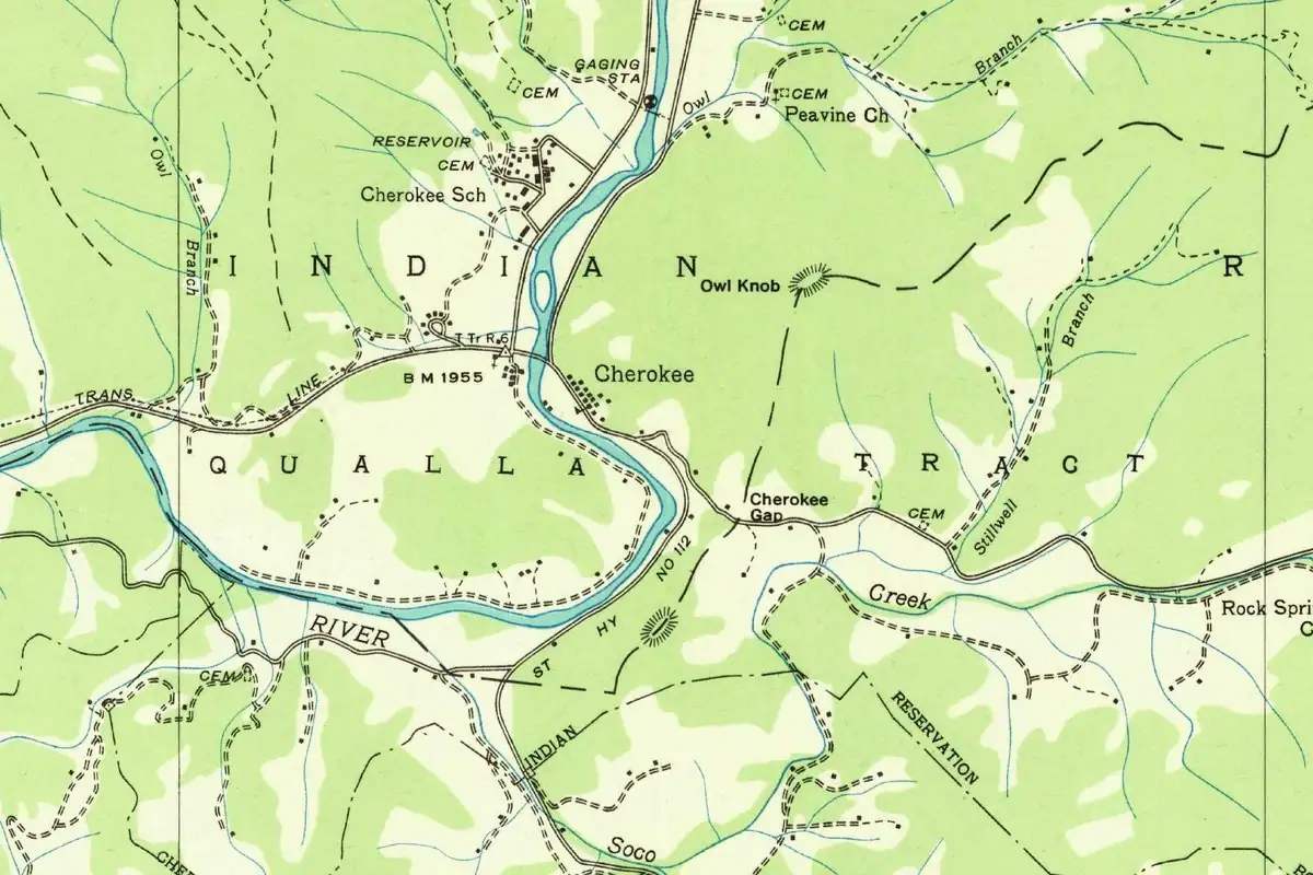
The Park Service page for the Charles Hall Museum says more than 3,000 North Carolina Cherokee prisoners, under the U.S. Army, walked through and camped at Tellico Plains in June 1838, on a 1,000-mile (1,609 km) journey to Indian Territory. Across the state line, Cherokee, North Carolina, sits on the Qualla Boundary, which The North Carolina Gazetteer calls the home of the Eastern Band of Cherokee Indians.
The town that grew up afterward was a different kind of place. The Tennessee Encyclopedia describes late 19th- and early 20th-century Tellico Plains as a logging and industrial town “controlled largely by Charles Andrew Scott.” The University of Tennessee’s Municipal Technical Advisory Service lists its charter as a private act of 1911.
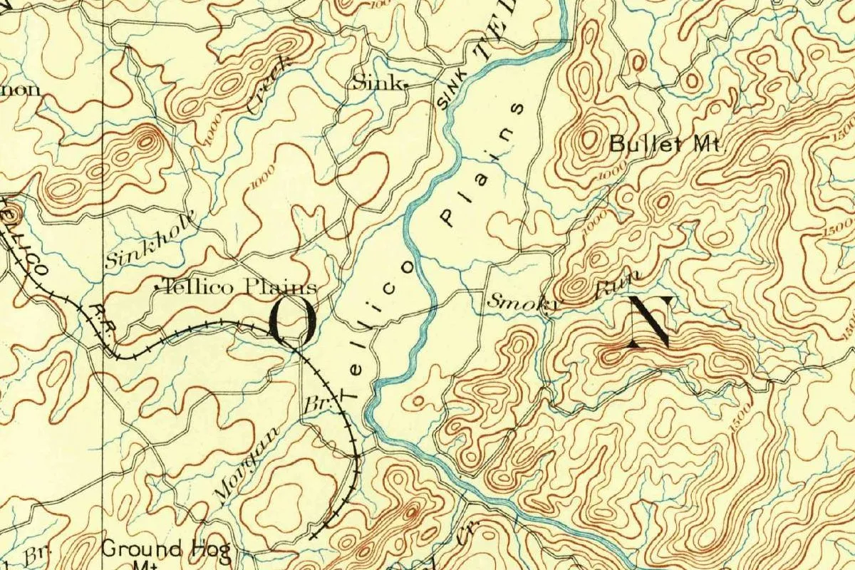
“Plains” on the 1893 map
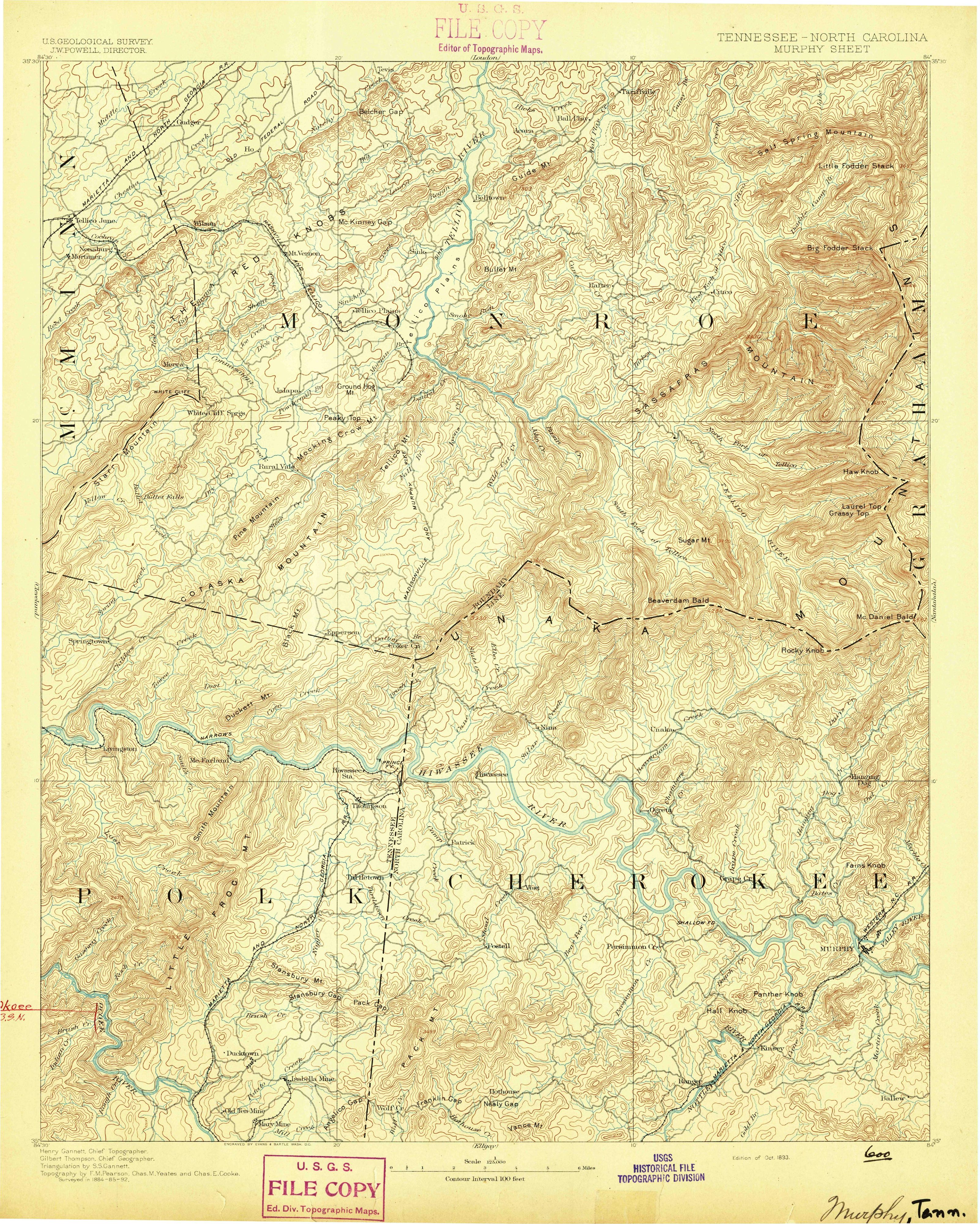
None of the sources here explains where “Plains” came from, and we won’t guess. What you can do is look at the map at the top of this page. It’s from the Geological Survey’s Murphy sheet, covering Tennessee and North Carolina. The margin names J. W. Powell as director, Henry Gannett as chief topographer and Gilbert Thompson as chief geographer, with triangulation by S. S. Gannett and topography by F. M. Pearson, Chas. M. Yeates and Chas. E. Cooke. It was “Surveyed in 1884-85-92,” engraved by Evans & Bartle of Washington, and this copy is the “Edition of Oct. 1893,” with no later printing line.
The sheet prints “Tellico Plains” twice. Once is the village label, beside the Tellico Railroad. The other is spread out in spaced letters across the flat valley along the river. You’ll also find Sinkhole, Sink, Smoky Run, Bullet Mt and Ground Hog Mt nearby, and the big O and N of the county name.
Quick answers
What does Tellico mean in Cherokee?
The sources disagree. James Mooney wrote in 1900 that “the meaning of the name is lost.” A dictionary on the Cherokee Nation’s language site translates it as “peace,” a town of refuge.
Why is it called Tellico Plains?
Because it’s at the site of Great Tellico, the Cherokee town Mooney places “at Tellico Plains.” No source here explains the word “Plains,” though the 1893 map prints the name across the river valley as well as on the village.
Is Tellico the same name as Tahlequah?
Yes, by Mooney’s account: Talikwa was “commonly written Tellico, Telliquo or, in the Indian Territory, Tahlequah.”
When was Tellico Plains incorporated?
In 1911, by a private act of the Tennessee legislature, according to the state’s Municipal Technical Advisory Service.
Key dates
- 1730Sir Alexander Cuming has the Cherokee chiefs name Moytoy of Tellico their 'emperor,' Mooney writes.
- 1736Christian Priber arrives among the Cherokee and draws up a plan of government with its capital at Great Tellico.
- 1819Tennessee creates Monroe County from former Overhill Cherokee lands.
- 1838More than 3,000 North Carolina Cherokee prisoners walk through and camp at Tellico Plains during the removal, in June.
- 1893The Geological Survey's Murphy sheet prints Tellico Plains as a village and across the river valley.
- 1900James Mooney writes that the meaning of Talikwa, or Tellico, is lost.
- 1911Tellico Plains gets its charter by a private act of the Tennessee legislature.
Things to do in Tellico Plains, Tennessee
Charles Hall Museum and Heritage Center
A nonprofit museum at the entrance to the Cherohala Skyway with more than 10,000 artifacts, panels on the Overhill Cherokee and the removal, and a walking trail beside fields where Indian mounds could still be seen in 1926.
Cherohala Skyway
A 43-mile (69 km) National Scenic Byway from Tellico Plains to Robbinsville, North Carolina, through the Cherokee and Nantahala national forests, climbing more than 4,500 feet (1,372 m) with overlooks along the way.
Bald River Falls
A 90-foot (27 m) waterfall on Tellico River Road (Forest Road 210), about 11 miles (18 km) from town by the Forest Service's directions, which it calls one of the most spectacular in the region.
Tellico River area
Nearly 30,000 acres (12,140 ha) of national forest backcountry along the Tellico and North rivers, with trout fishing, the Benton MacKaye Trail and Civilian Conservation Corps buildings at the Tellico Ranger Station.
Getting there
Open Tellico Plains in Google Maps
Opens in a new tab. The pin is the center of Tellico Plains in the USGS place-name record.
The closest airports, Amtrak stations and intercity bus stops, measured in a straight line from the center of Tellico Plains.
Airports
- McGhee Tyson (TYS) Alcoa 35 mi 57 km
- Lovell Field (CHA) Chattanooga 56 mi 90 km
- Hartsfield/Jackson Atlanta International (ATL) 120 mi 192 km
Amtrak trains
- Toccoa station (TCA) 77 mi 124 km
- Gainesville station (GNS) 79 mi 127 km
Intercity buses
- Greyhound Athens Exxon 21 mi 34 km
Distances are as the crow flies, not by road. We don't list schedules or fares because they change; check with the airline, Amtrak or the bus company before you go. Official data (FAA commercial service airports (2025), FAA airport locations, Amtrak stations and Intercity Bus Atlas) from the FAA and the U.S. Bureau of Transportation Statistics, checked Nov 18, 2026.
Sponsored
Staying in Tellico Plains?
Compare hotels in Tellico Plains, Tennessee, on Expedia.
See hotels in Tellico PlainsWe may earn a commission if you buy through this link. It never changes what we write. Read our affiliate disclosure
Historical Sources & References
- James Mooney, Myths of the Cherokee (1900), pp. 35-37, 533. Cuming and “Moytoy, of Tellico” in 1730; Priber’s government “with the capital at Great Tellico”; the glossary entry Tălikwă′, “Great Tellico, at Tellico Plains,” and “The meaning of the name is lost.” Pages 37 and 533 checked against the page images.
- Cherokee-English dictionary on the Cherokee Nation language site. “Tellico … Tlalekwa — Tellico, peace,” “a town of refuge, or peace town,” and “peace, hence Tellico, Talequah, Peace Towns.” The file names no compiler.
- National Park Service, Charles Hall Museum and Heritage Center. “Great Teliquo was an important township of the Cherokee Nation,” the removal of June 1838, the mounds still visible in 1926, and the museum’s collections.
- Tennessee Encyclopedia, “Monroe County”. The county of 1819, “Great Talequah,” the logging town and Charles Andrew Scott.
- MTAS, Tellico Plains charter. The private act of 1911.
- Cherohala Skyway; Bald River Falls; Tellico River. Cherokee National Forest pages, for the things-to-do list.
- U.S. Geological Survey, GNIS feature 1304037. Where the national names database puts the town, in Monroe County.
- Murphy sheet, surveyed 1884–85 and 1892, edition of October 1893. The sheet the map at the top was cropped from.
Sponsored
Put this 1893 map on your wall
The Geological Survey's 1893 Murphy sheet, which writes Tellico Plains on the village and across the river valley, is in the public domain. Download the full-size scan for free, then have it printed on canvas with CanvasOnTheCheap.
Print a map on canvasDownload the full-size mapWe may earn a commission if you buy through this link. It never changes what we write. Read our affiliate disclosure
Spot something wrong, or know more? Tell us here. You can also email us or use our contact page. Corrections are noted here with their date, never made silently.