Sanderson, Texas: Strawbridge Until the Roundhouse
Sanderson, Texas, began as a railroad stop called Strawbridge and was renamed in 1882 for Thomas P. Sanderson, the engineer in charge of construction. The switch came with the roundhouse, when the spot became a division point on the Southern Pacific.
Charlie Wilson’s Strawbridge
The town’s founder was Charlie Wilson, who started it “as Strawbridge,” according to Swanya Howell Pitts in the Handbook of Texas. The Handbook‘s Terrell County entry, by Walter G. Downie, gives him as Cyrus W. (Charley) Wilson and adds how he did it: at a designated stop on the route the Texas and New Orleans Railroad had surveyed, he “bought the land and laid out streets and lots.” The Federal Writers’ Project remembered him in 1940 as “‘Uncle’ Charlie Wilson, the town’s founder in the 1880’s.”
Neither entry tells you where the name Strawbridge came from, and both spell it the same way. It was simply what the stop was called when the tracks were still on the way.
The engineer’s name
The railroad changed the name. In Pitts’s words, “in 1882 when a roundhouse was built, the name was changed from Strawbridge to Sanderson, after Thomas P. Sanderson, the engineer in charge of construction.” Downie dates it to May 1882, “when the Galveston, Harrisburg and San Antonio Railroad reached the site,” and calls the namesake simply “a railroad engineer.”
So both entries agree on the year, the reason and the kind of man. A post office followed in 1883. Sanderson didn’t become a county seat until 1905, when Terrell County was carved out of Pecos County and a countywide election picked it.
A crew-change town in a canyon
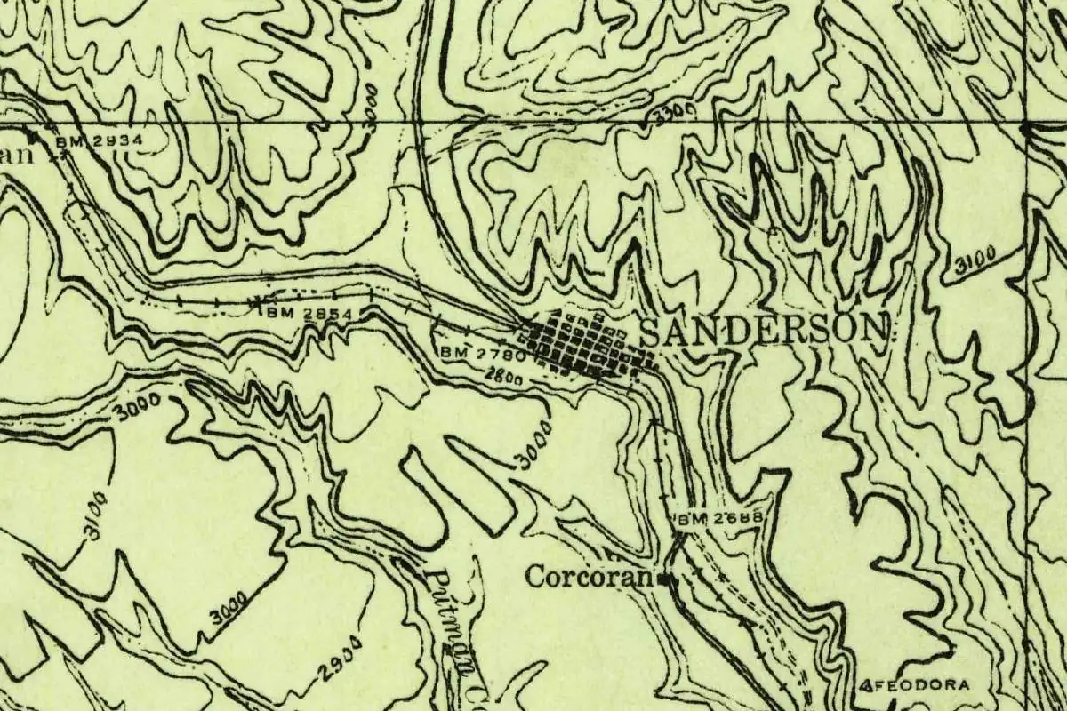
The 1928 survey map shows you why the place mattered to the railroad and why it was a hard spot for a town. Sanderson is a small grid squeezed into the bottom of Sanderson Canyon, with the tracks running through it and steep contour lines crowding in on both sides. In 1940 the WPA writers called it “a repair and crew change point on the Southern Pacific, with large railroad shops and yards,” and it said one canyon wall “rises over the main street.”
That canyon could turn deadly. On June 11, 1965, a flash flood sent a wall of water down Sanderson Canyon into town, and twenty-six people died. Eleven flood-control dams were built afterward to protect the town against another one, Pitts writes. The name, though, still belongs to the engineer who brought the railroad through.
Quick answers
Where does the name Sanderson, Texas, come from?
Thomas P. Sanderson, the engineer in charge of the railroad’s construction, according to the Handbook of Texas. The name changed in 1882, when the roundhouse was built.
What was Sanderson, Texas, called before?
Strawbridge. That’s the name Charlie Wilson’s town had at a designated stop on the railroad’s surveyed route, before 1882.
What role did Sanderson, Texas, play for the Southern Pacific?
It was a division point with a roundhouse from 1882, and in 1940 it was still a repair and crew change point on the Southern Pacific, with large shops and yards.
Key dates
- 1882The railroad reaches the site in May and builds a roundhouse; Strawbridge becomes Sanderson.
- 1883A post office opens.
- 1905Terrell County is formed, and a countywide election makes Sanderson the county seat.
- 1965A flash flood roars down Sanderson Canyon on June 11, killing twenty-six people.
Getting there
Open Sanderson in Google Maps
Opens in a new tab. The pin is the center of Sanderson in the USGS place-name record.
The closest airports, Amtrak stations and intercity bus stops, measured in a straight line from the center of Sanderson.
Airports
- Midland International Air And Space Port (MAF) 125 mi 201 km
- San Angelo Regional/Mathis Field (SJT) 141 mi 226 km
Amtrak trains
- Sanderson station (SND) under 1 mi 0.5 km
- Alpine station (ALP) 77 mi 124 km
Distances are as the crow flies, not by road. We don't list schedules or fares because they change; check with the airline, Amtrak or the bus company before you go. Official data (FAA commercial service airports (2025), FAA airport locations, Amtrak stations and Intercity Bus Atlas) from the FAA and the U.S. Bureau of Transportation Statistics, checked Nov 6, 2026.
Sponsored
Staying in Sanderson?
Compare hotels in Sanderson, Texas, on Expedia.
See hotels in SandersonWe may earn a commission if you buy through this link. It never changes what we write. Read our affiliate disclosure
Historical Sources & References
- Swanya Howell Pitts, “Sanderson, TX,” Handbook of Texas Online (TSHA). Founded by Charlie Wilson “as Strawbridge”; the 1882 roundhouse and the change to Sanderson “after Thomas P. Sanderson, the engineer in charge of construction”; the 1883 post office; the 1905 county seat election; the June 11, 1965, flood and the eleven flood-control dams.
- Walter G. Downie, “Terrell County,” Handbook of Texas Online (TSHA). Cyrus W. (Charley) Wilson’s townsite at a stop on the Texas and New Orleans survey; the renaming in May 1882 “after a railroad engineer.”
- Federal Writers’ Project, Texas: A Guide to the Lone Star State (1940), p. 615. The canyon wall that “rises over the main street,” “Uncle” Charlie Wilson and the “repair and crew change point on the Southern Pacific.”
- GNIS feature 1346563 (U.S. Geological Survey). The gazetteer record and coordinates for Sanderson, in Terrell County.
Spot something wrong, or know more? Tell us here. You can also email us or use our contact page. Corrections are noted here with their date, never made silently.