Worland, Wyoming: The Town That Slid Across the Ice
Worland, Wyoming, grew up around Dad Worland’s dugout stage stop, and then the whole town slid across the frozen Bighorn River to meet the railroad. It’s named for the man who dug in first, Charles H. “Dad” Worland.
A dugout called the Hole in the Wall
The City of Worland dates the start to 1900, when Dad Worland “dug his underground stage stop here on the old Bridger Trail.” Annette Hein, who wrote the Washakie County entry for WyoHistory.org, says that, living on the west bank of the river, he opened a small bar and general store for travelers that year.
A 1955 article in the Annals of Wyoming fills in the man. Mary F. Bragg drew on a book by C. F. Robertson, Worland’s first mayor, who arrived in 1903 with a survey party for an irrigation project. Robertson found Dad Worland homesteaded near Fifteen Mile Creek and living in a dugout he called “The Hole in the Wall.” He’d trailed sheep all over the West, Bragg writes, and first came to the Big Horn Basin selling fruit trees for the Stark Nurseries of Missouri. “A hundred miles from the nearest railroad he took up his land, dug in, and waited cheerfully for civilization to come his way.”
It came in the form of a post office. Bragg says the log cabin became one in 1904, with Dad Worland as the first postmaster, at about the time the Hanover Land and Irrigation Company incorporated on June 20, 1904. A former clerk wrote that his main job, at sixteen, was collecting thirty-five cents a meal from each passenger off the stage between Garland and Thermopolis.
Moving day on the Bighorn
By 1906 the settlement, “Worland’s,” as Hein calls it, had a problem. The Burlington was building south from Montana, and the tracks passed close by, but on the east side of the river. So the residents moved the town. They used horses to slide the buildings across the frozen river in January and February 1906, Hein writes, and the hotel spent several days stuck on the bank, leaning to one side, while business went on inside. The city’s account says they slid the buildings on skids.
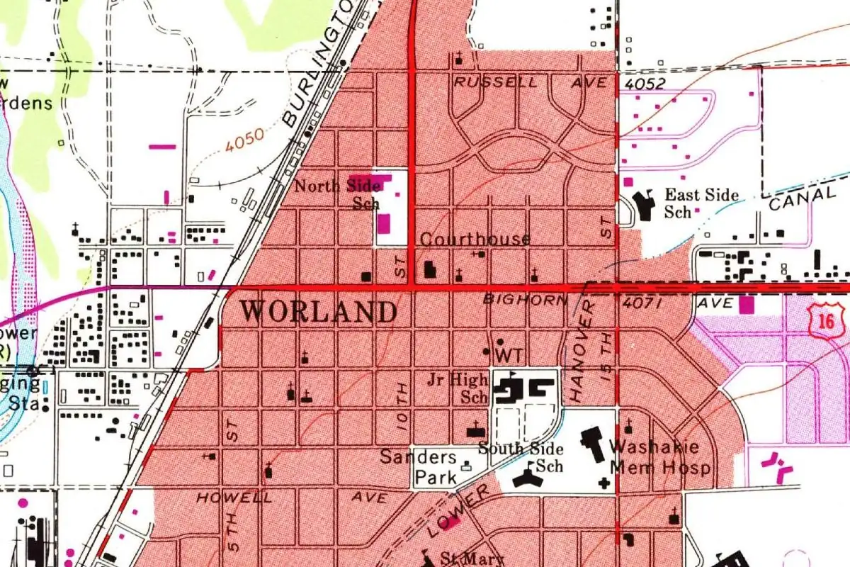
That’s why, in the street grid the Geological Survey drew in 1967, you’ll find Worland’s grid east of the river and right up against the Burlington tracks. The city’s history says Worland was incorporated in 1906, while Bartlett’s 1918 History of Wyoming says the town incorporated just in time for the 1910 census, which counted 265 people. When Washakie County was split off in 1911, Worland became its seat.
The marker on the old side of the river
In 1954 the Worland Woman’s Club and the state’s Historical Landmark Commission put a granite marker near the original townsite, on the west side of the river. It was dedicated on August 27, 1954, and Bragg copied its inscription:
“To all pioneers and in memory of C. H. “Dad” Worland for whom the town is named. He erected the stage station on the old Bridger Trail about 100 yards north of here. That spot was the original townsite established in 1904. The town moved across the river in 1906. …”
So if you stand at the marker, you’re within a stone’s throw of where the name started, while the town that carries it sits across the water, where the buildings landed after their trip over the ice.
Quick answers
Who was Dad Worland?
Charles H. “Dad” Worland, the homesteader who kept a stage station on the old Bridger Trail and became the first postmaster. The 1954 townsite marker says he is the man “for whom the town is named.”
Did Worland really move across a river?
Yes. In January and February 1906, residents used horses to slide the buildings across the frozen Bighorn River to the side where the railroad was being built, Hein writes.
What was Worland called before?
The city calls the early settlement Camp Worland, and Hein calls it “Worland’s.” Both carry the same man’s name.
Key dates
- 1900Dad Worland opens a stage stop, bar and store on the west bank of the Bighorn River.
- 1904The post office opens with Dad Worland as postmaster; the Hanover Land and Irrigation Company incorporates on June 20.
- 1906In January and February, residents slide the town's buildings across the frozen river to the railroad side.
- 1911Washakie County is created, with Worland as its county seat.
- 1954A granite marker for the original townsite is dedicated on August 27.
Getting there
Open Worland in Google Maps
Opens in a new tab. The pin is the center of Worland in the USGS place-name record.
The closest airports, Amtrak stations and intercity bus stops, measured in a straight line from the center of Worland.
Airports
- Yellowstone Regional (COD) Cody 63 mi 102 km
- Central Wyoming Regional (RIW) Riverton 71 mi 113 km
Intercity buses
- Express Arrow Worland under 1 mi 0.2 km
Distances are as the crow flies, not by road. We don't list schedules or fares because they change; check with the airline, Amtrak or the bus company before you go. Official data (FAA commercial service airports (2025), FAA airport locations, Amtrak stations and Intercity Bus Atlas) from the FAA and the U.S. Bureau of Transportation Statistics, checked Nov 6, 2026.
Sponsored
Staying in Worland?
Compare hotels in Worland, Wyoming, on Expedia.
See hotels in WorlandWe may earn a commission if you buy through this link. It never changes what we write. Read our affiliate disclosure
Historical Sources & References
- Mary F. Bragg, “Dedication of Worland Townsite Marker,” Annals of Wyoming 27, no. 1 (April 1955), pp. 19-21. The marker’s inscription, the 1904 post office with Dad Worland as postmaster, Robertson’s meeting with him in 1903, the “Hole in the Wall” dugout and the stage-meal story.
- City of Worland, “History”. Dad Worland’s underground stage stop of 1900, Camp Worland and the buildings slid across the frozen river on skids.
- Annette Hein, “Washakie County, Wyoming,” WyoHistory.org. The 1900 bar and store, the Burlington on the east bank and the move across the ice in January and February 1906; Washakie County created in 1911.
- I. S. Bartlett, ed., History of Wyoming, vol. 1 (1918), p. 611. Incorporated in time for the 1910 census, with 265 people.
- GNIS feature 1596624 (U.S. Geological Survey). The gazetteer record for Worland, in Washakie County.
Spot something wrong, or know more? Tell us here. You can also email us or use our contact page. Corrections are noted here with their date, never made silently.