Ouray, Colorado: Uncompahgre City and a Ute Leader's Name
Ouray is named for Ouray, the leader of the Tabeguache, or Uncompahgre, band of Utes who died in 1880. Prospectors laid out the town in 1875 as Uncompahgre City, and it was incorporated as Ouray in 1876. The Colorado Encyclopedia says his name means "Arrow" in Ute; Henry Gannett's 1905 bulletin called it a Ute version of "Willie."
Ouray, Colorado, was laid out in 1875 as Uncompahgre City, and by late 1876 it bore the name of Ouray, a Ute leader whose treaties cost the Utes land. The town’s own historic survey admits the link between the man and the place rests “as much through tradition and legend as physical connection.”
Uncompahgre City, 1875
The San Juan Mountains were Ute land until the 1870s. On September 13, 1873, according to the 2005 historic resources survey the City of Ouray commissioned, the Utes signed an agreement with Felix Brunot, and Congress ratified it on April 29, 1874. The survey says that agreement ended Ute occupation and officially opened the San Juans to prospecting, mining and settlement.
They didn’t waste time. The first important gold strike near the future town, the Trout and Fisherman claims, came on August 23, 1875. “Within a week,” the survey says, “the townsite of ‘Uncompahgre City’ had been laid out; it would soon be incorporated as Ouray.” D. W. Brunton surveyed it, and a group of six men laid it out on August 28.
Uncompahgre was already the name of the river the town sits on, at the head of a valley boxed in by peaks, about 37 miles (60 km) south of Montrose and 23 miles (37 km) north of Silverton. The survey puts it at 7,800 feet (2,377 m).
The switch to Ouray
The survey doesn’t say who proposed the new name or why. It only records the result: in 1876 the townsite was surveyed again, by Hubbard W. Reed, and incorporated “as ‘Ouray,’” with Ira Y. Munn, Robert F. Long, Milton W. Cline, Theron Stevens and James Call as its first board of trustees. Long and Cline had been among the men who laid out Uncompahgre City the year before. The next January, Ouray County was created, and the town became its seat.
You might expect a firm date for something that official, but the survey gives two. On one page, the town was incorporated on October 21, 1876. Fourteen pages later, it’s October 2. Either way, Uncompahgre City lasted little more than a year.
The man behind the name
Ouray wasn’t a legend invented for a mining camp. The Colorado Encyclopedia, published by Colorado Humanities, says he was born in 1833 in Abiquiú, New Mexico, to a Jicarilla Apache father and a Tabeguache Ute mother, and led the Tabeguache, or Uncompahgre, band. A photo caption there calls him one of the most influential leaders of the Northern Ute people. He had no ultimate authority over all the Utes, the encyclopedia notes, but the U.S. government gave him the title of chief of all the Utes in Colorado and made him the main contact for treaty talks.
The encyclopedia says the agreements Ouray negotiated led to the loss of Ute land and, in the end, the removal of the White River and Uncompahgre Utes from Colorado.
The city’s survey fills in his early years. Ouray grew up between Taos and Abiquiú, it says, learned Spanish and often attended Catholic mass. As a young man he became the spokesman for the seven Ute bands in treaty talks, and in 1859, after his first wife, Black Mare, died, he married Chipeta, who stayed at his side for the rest of his life.
Did Ouray ever spend time there? The city’s survey says it’s “known that Ouray favored the local hot springs,” and that a small adobe hut just outside today’s historic district is “believed to have been Ouray’s ‘mountain home.’” It’s careful about all of it. That’s where the “tradition and legend” line comes from.
Ouray died four years after the town took his name. He fell ill on a trip to southwest Colorado and died on the Southern Ute reservation on August 24, 1880, the encyclopedia says.
What does “Ouray” mean?
Two sources give two very different answers, and you should know who said each.
The Colorado Encyclopedia says Ouray’s name means “Arrow” in the Ute language. Its entry on Ouray County puts it as “the arrow.”
Henry Gannett saw it another way in 1905. His Geological Survey bulletin says the county, the city and a mountain in Colorado were “named for a friendly chief of the Ute Indians,” and adds one more sentence: “The Ute Indian corruption of ‘Willie.’” Gannett doesn’t say where that came from, or whose Willie.
Neither source shows its work from the Ute language, so this article doesn’t pick one. What’s not in question is who the town honors.
Ouray on the 1902 map
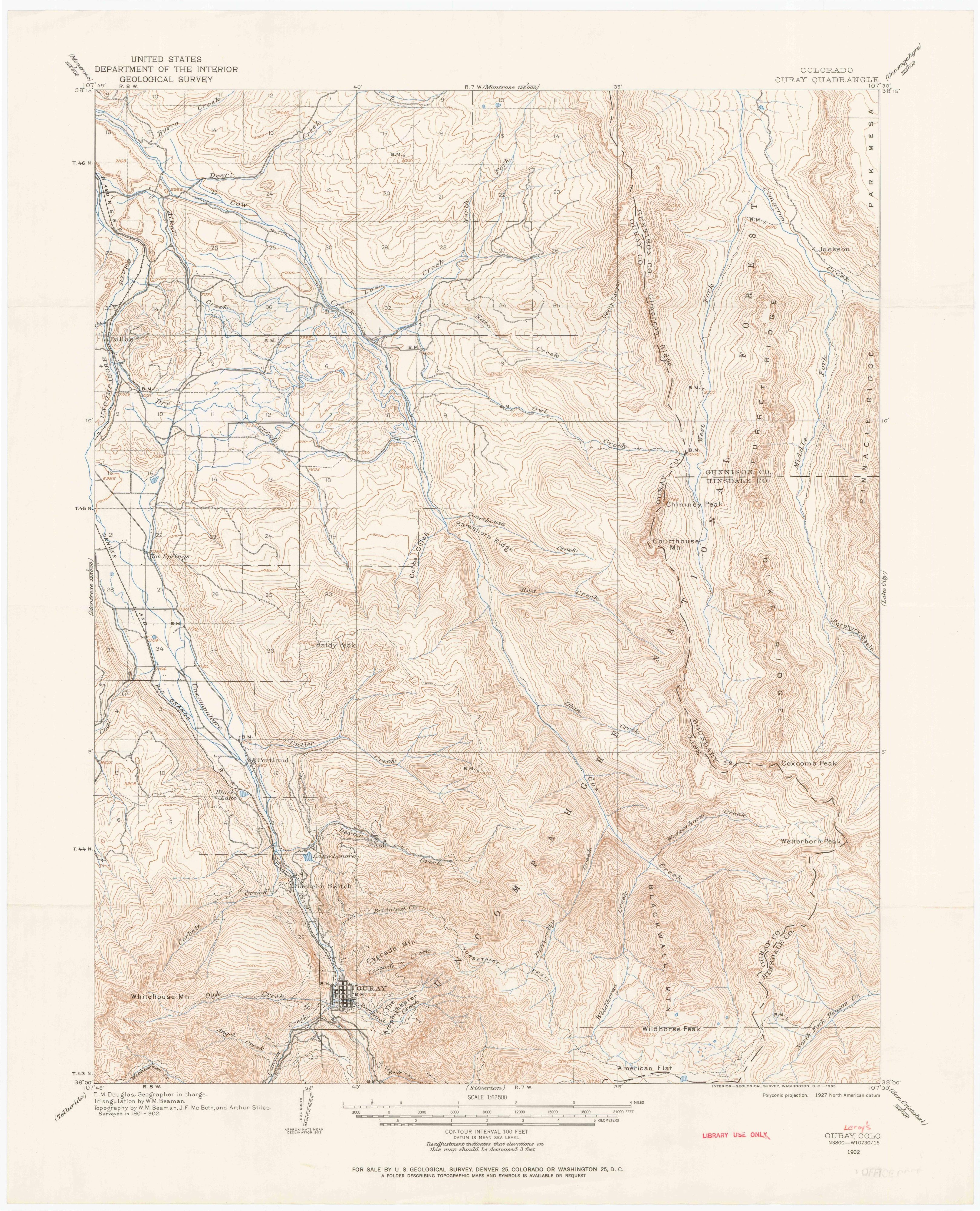
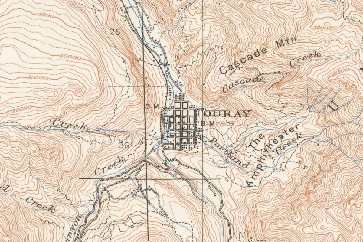
The map at the top of this page comes from a Geological Survey sheet surveyed in 1901 and 1902, a quarter century after the renaming. It shows how little room the town had: a tight grid of a few blocks on the valley floor, with the contour lines stacked so close on every side that they nearly merge. Benchmarks in town read 7,709 and 7,803 feet (2,350 and 2,378 m). Cascade Mountain rises just to the northeast, and The Amphitheater is labeled east of town.
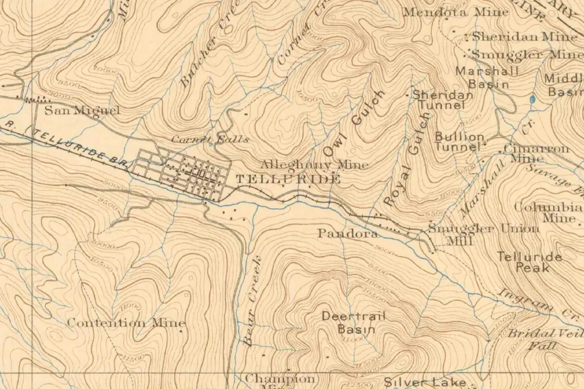
If you’re touring the San Juans, Telluride is another mining town that traded its first name for a new one. Grand Junction went by Ute before it settled on its name, and it opened to settlers only after the Utes were forced out in 1881. There are more stories on our Colorado page.
Quick answers
Who is Ouray, Colorado, named after?
Ouray, the leader of the Tabeguache, or Uncompahgre, band of Utes, who negotiated a series of treaties with the U.S. government. Gannett’s 1905 bulletin and the City of Ouray’s historic survey both name him.
What was Ouray, Colorado, called before?
Uncompahgre City. The city’s 2005 survey says the townsite was laid out under that name in August 1875 and incorporated as Ouray in 1876.
What does the name Ouray mean?
The sources don’t agree. The Colorado Encyclopedia says it means “Arrow” in Ute; Henry Gannett wrote in 1905 that it was “the Ute Indian corruption of ‘Willie.’”
Did Chief Ouray live in Ouray?
The survey doesn’t say he did. It says he favored the local hot springs and that a hut east of the historic district is believed to have been his “mountain home,” but it calls the connection as much tradition and legend as physical.
Key dates
- 1833Ouray is born in Abiquiú, New Mexico, to a Jicarilla Apache father and a Tabeguache Ute mother.
- 1874Congress ratifies the Brunot agreement, under which the Utes give up the San Juan Mountains.
- 1875Prospectors stake the Trout and Fisherman claims on August 23 and lay out Uncompahgre City within a week.
- 1876The town is incorporated as Ouray in October.
- 1880Ouray dies on the Southern Ute reservation on August 24.
Things to do in Ouray, Colorado
Ouray Hot Springs Pool
A sulfur-free hot springs pool fed mainly by mineral water from Box Canyon, carried more than a mile to the pool. The town's survey says Ouray himself favored the local hot springs.
Box Cañon Falls
A city park where Canyon Creek surges through a narrow quartzite gorge and plunges over a waterfall, seen up close from a trail, bridges and viewing platforms. It's also home to the rare black swift.
Ouray County Historical Society & Museum
The county's history museum and archive, with exhibits and programs on Ouray County and the San Juan Mountains, including the history of the area's hot springs.
Ouray Ice Park
A human-made public ice climbing park carved into the natural Uncompahgre Gorge, within walking distance of downtown, run every winter by a nonprofit.
Ute Indian Museum
History Colorado's museum in Montrose, built in 1956 near the ranch of Ouray and his wife Chipeta, with the Chief Ouray memorial park and Chipeta's grave on its grounds.
Getting there
Open Ouray in Google Maps
Opens in a new tab. The pin is the center of Ouray in the USGS place-name record.
The closest airports, Amtrak stations and intercity bus stops, measured in a straight line from the center of Ouray.
Airports
- Telluride Regional (TEX) 14 mi 22 km
- Montrose Regional (MTJ) 36 mi 58 km
Amtrak trains
- Grand Junction station (GJT) 87 mi 140 km
Intercity buses
- Bustang Outrider Bustang · Ridgway 10 mi 16 km
- Greyhound Durango W 8th St 53 mi 85 km
Distances are as the crow flies, not by road. We don't list schedules or fares because they change; check with the airline, Amtrak or the bus company before you go. Official data (FAA commercial service airports (2025), FAA airport locations, Amtrak stations and Intercity Bus Atlas) from the FAA and the U.S. Bureau of Transportation Statistics, checked Nov 14, 2026.
Sponsored
Staying in Ouray?
Compare hotels in Ouray, Colorado, on Expedia.
See hotels in OurayWe may earn a commission if you buy through this link. It never changes what we write. Read our affiliate disclosure
Historical Sources & References
- Henry Gannett, The Origin of Certain Place Names in the United States (1905), p. 235. Ouray county, city and mountain, “named for a friendly chief of the Ute Indians. The Ute Indian corruption of ‘Willie.’”
- Cathleen M. Norman, 2004-2005 Historic Resources Survey of the Ouray National Register Historic District (City of Ouray, 2005), p. 1. The town’s location, its distances from Montrose and Silverton, and its elevation.
- Norman (2005), p. 18. The Brunot agreement of 1873-74; Ouray’s tie to the town “as much through tradition and legend as physical connection”; the hot springs and the “mountain home.”
- Norman (2005), p. 20. The Brunot agreement ending Ute occupation of the San Juans; the Trout and Fisherman claims of August 23, 1875, “Uncompahgre City” laid out within a week, and incorporation on October 21, 1876.
- Norman (2005), p. 34. The townsite “originally called ‘Uncompahgre,’” laid out on August 28, resurveyed in 1876, incorporated “as ‘Ouray’” on October 2, 1876, and Ouray County created in January 1877.
- Colorado Encyclopedia, “Ouray”. His name “means ‘Arrow’ in the Ute language,” his birth, his role in the treaties, the removal of the Uncompahgre Utes and his death in 1880.
- Colorado Encyclopedia, “Ouray County”. The county named for Ouray, “whose name translates to ‘the arrow.’”
- History Colorado, Ute Indian Museum. The museum near Ouray and Chipeta’s ranch in Montrose.
- GNIS feature 204753 (U.S. Geological Survey). The USGS listing for Ouray, Ouray County, with its coordinates.
- U.S. Geological Survey, Ouray sheet (1902). The 1:62,500 map, surveyed in 1901-1902, that the image at the top of this page was cropped from.
Sponsored
Put this 1902 map on your wall
The 1902 USGS Ouray sheet, in a 1963 printing, is in the public domain. Download the full-size scan for free, then have it printed on canvas with CanvasOnTheCheap.
Print a map on canvasDownload the full-size mapWe may earn a commission if you buy through this link. It never changes what we write. Read our affiliate disclosure
Spot something wrong, or know more? Tell us here. You can also email us or use our contact page. Corrections are noted here with their date, never made silently.