High Point, North Carolina: The Top of the Railroad
High Point, North Carolina, has a name that’s just a description: it was named as the highest point on the railroad from Goldsboro to Charlotte. Three sources, written between 1905 and 2025, say so in nearly the same words.
The top of the line
Henry Gannett’s bulletin of 1905 calls it a village in Guilford County “so named because it is the highest point on the North Carolina Railroad.” The Federal Writers’ Project’s 1939 guide to the state puts it this way: “Named because it was the highest point on the railroad line between Goldsboro and Charlotte.” And NCpedia, the state library’s encyclopedia, says the town was “so named because it was the highest point on the Goldsboro-Charlotte Railroad.”
They don’t quite agree on what to call the railroad. Gannett says the North Carolina Railroad, NCpedia says the Goldsboro-Charlotte Railroad, and the WPA guide, oddly, calls it the “State-built North Carolina & Midland Railroad.” All three are talking about the line from Goldsboro to Charlotte, which also ran through Durham.
A town drawn square
The WPA writers tell how the town was laid out. Guilford County had been settled by Quakers around 1750, they say, “but the town was not laid out until 1853” when the railroad came through. That year Solomon Kendall sold part of his farm for $5,000 for a town site “laid out exactly square, 2 miles long and 2 miles wide,” or about 3.2 km on a side.
The surveyors took the square seriously. They were “so intent” on precise dimensions, the guide says, that “they ran the eastern boundary ‘through the doors of Jane Parson’s house.’”
Rails and planks
A second road made the crossing. In 1854, the guide says, the plank road between Salem and Fayetteville was finished, 130 miles (209 km) long, and the new village “became an important trading center.” NCpedia agrees that the town “grew up at the intersection of the railroad line and the Fayetteville and Western Plank Road.” The WPA guide adds a small detail: the mileposts had the numbers carved instead of painted, “so night travelers could feel the figures.” High Point was incorporated in 1859.
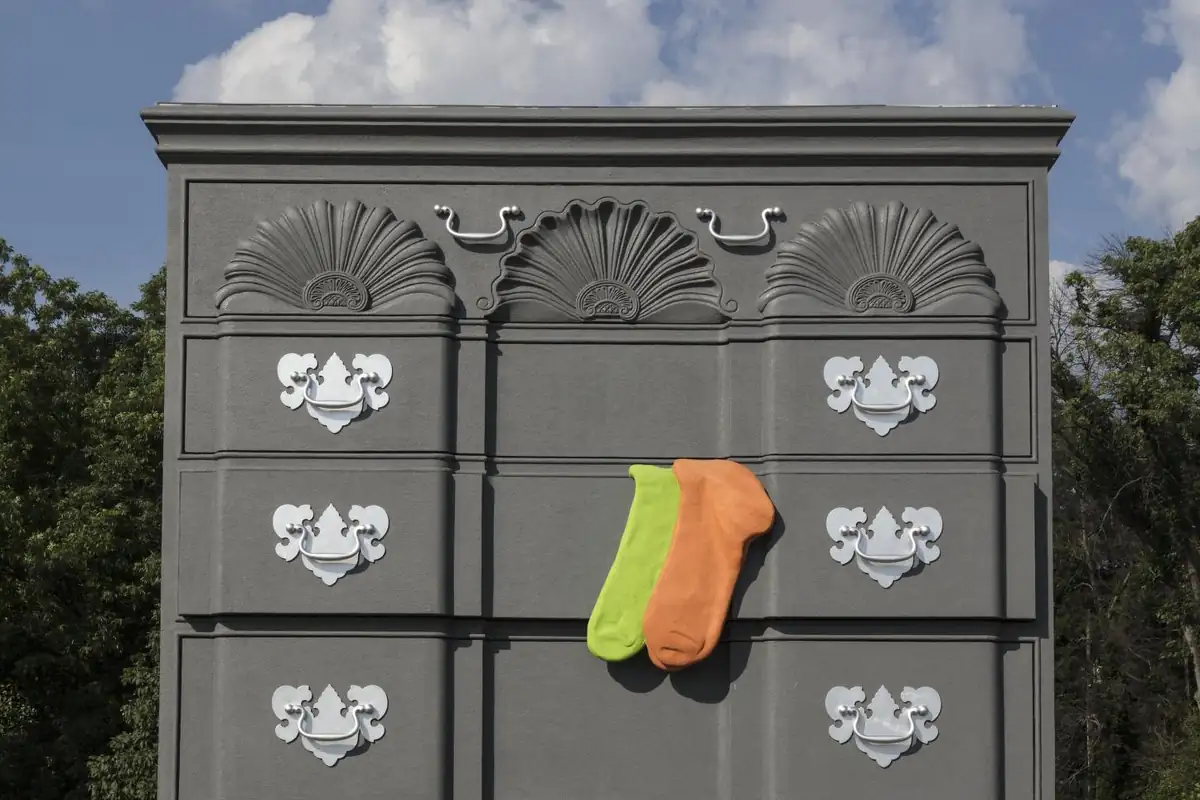
Furniture came later. The WPA writers say furniture makers showed up in 1888, “attracted by the abundance of hardwood timber available,” and NCpedia dates the High Point Furniture Company to 1889. That’s the trade the giant chest of drawers in the photo below points to.
On the map
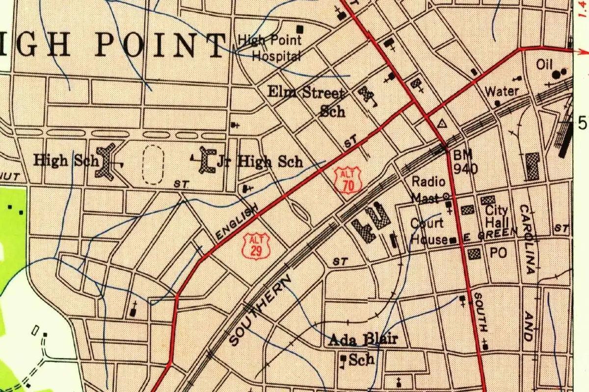
The 1949 survey map shows the Southern’s tracks cutting diagonally through downtown, past the court house, city hall and post office. Where a main street crosses them, the surveyors marked a benchmark: 940 feet (287 m) above sea level. The map can’t tell you whether that’s the top of the whole line. For that you have to take the word of Gannett, the WPA and NCpedia.
Quick answers
Why is it called High Point, North Carolina?
Because it was the highest point on the railroad between Goldsboro and Charlotte. Gannett (1905), the WPA guide (1939) and NCpedia all give that reason.
When was High Point founded?
The town was laid out in 1853, when the railroad came through and Solomon Kendall sold part of his farm for the site. It was incorporated in 1859.
What crossed the railroad at High Point?
The plank road between Salem and Fayetteville, finished in 1854. NCpedia calls it the Fayetteville and Western Plank Road.
Key dates
- 1853The railroad comes through, and Solomon Kendall sells part of his farm for $5,000 for a square town site.
- 1854The plank road between Salem and Fayetteville is finished, crossing the railroad here.
- 1859High Point is incorporated.
Getting there
Open High Point in Google Maps
Opens in a new tab. The pin is the center of High Point in the USGS place-name record.
The closest airports, Amtrak stations and intercity bus stops, measured in a straight line from the center of High Point.
Airports
- Piedmont Triad International (GSO) Greensboro 11 mi 17 km
- Concord-Padgett Regional (JQF) 56 mi 90 km
- Raleigh-Durham International (RDU) 68 mi 110 km
Amtrak trains
- High Point station (HPT) under 1 mi 0.2 km
- Greensboro station (GRO) 15 mi 23 km
Intercity buses
- Greyhound High Point Transportation Terminal under 1 mi 0.3 km
- FlixBus Greensboro Bus Stop 14 mi 23 km
- Sunway Charters Greensboro 14 mi 23 km
Distances are as the crow flies, not by road. We don't list schedules or fares because they change; check with the airline, Amtrak or the bus company before you go. Official data (FAA commercial service airports (2025), FAA airport locations, Amtrak stations and Intercity Bus Atlas) from the FAA and the U.S. Bureau of Transportation Statistics, checked Nov 6, 2026.
Sponsored
Staying in High Point?
Compare hotels in High Point, North Carolina, on Expedia.
See hotels in High PointWe may earn a commission if you buy through this link. It never changes what we write. Read our affiliate disclosure
Historical Sources & References
- Federal Writers’ Project, North Carolina: A Guide to the Old North State (1939), p. 215. The town laid out in 1853, Solomon Kendall’s $5,000 sale, the square town and Jane Parson’s house, the name “because it was the highest point on the railroad line between Goldsboro and Charlotte,” the plank road of 1854 and its carved mileposts, incorporation in 1859, and the furniture makers of 1888.
- Henry Gannett, The Origin of Certain Place Names in the United States, 2nd ed. (1905), p. 156. “So named because it is the highest point on the North Carolina Railroad.”
- Steven Case, “High Point,” NCpedia (2010, rev. 2025). Incorporated in 1859, “so named because it was the highest point on the Goldsboro-Charlotte Railroad,” the crossing with the Fayetteville and Western Plank Road, and the High Point Furniture Company of 1889.
- GNIS feature 986755 (U.S. Geological Survey). The government names file for High Point, Guilford County, which gives no history.
Spot something wrong, or know more? Tell us here. You can also email us or use our contact page. Corrections are noted here with their date, never made silently.