What Does Yachats Mean? The Alsea Village Behind the Name
Yachats comes from Ya'xaik, the Alsea name of the village where the Yachats River meets the ocean, and the Siletz tribes say English took it from the Coos pronunciation, Yahach. Its meaning is disputed. Readings gathered by Joanne Kittel and Suzanne Curtis include 'dark water at the foot of the mountain' and 'where the trail leaves the beach.'
Yachats, Oregon, keeps a version of Ya’xaik, the name of an Alsea village at the river mouth, but what the word means is still argued over. The Oregon Encyclopedia gives the pronunciation as YAH-hots, which already tells you the spelling took a long road to get here.
Ya’xaik, the village at the river mouth
The clearest statement comes from the Confederated Tribes of Siletz Indians. In a 2025 list of Oregon place names with Indigenous origins, the tribes say the town “retains a version of the original name” of an Alsea village that had stood at the spot since time immemorial, a village the Alsea call Ya’xaik. They also explain where the English spelling came from: “The Coos pronunciation of the village name, Yahach, became the basis for the version of the word that English speakers use today.”
The same entry is blunt about what happened next. Oral tradition holds that some of the first epidemics to reach western Oregon, early in the 1800s, struck the village with particular force. In 1859 the government made the site the southern headquarters of the Coast, or Siletz, Reservation, to watch over the Alsea, and started forcing Hanis, Miluk, Siuslaw and Lower Umpqua people to move there. Hanis and Miluk are the two Coos languages, the people whose name is also on Coos Bay, farther south. Coos and Lower Umpqua families spent a generation barely getting by there, the tribes say, until the land was opened to settlers in 1876. The Oregon Encyclopedia puts the subagency’s closing at about 1875.
A word spelled a dozen ways
The longest look at the name is a booklet by Joanne Kittel and Suzanne Curtis, The Yaxaik Native People, Origins of the Yachats Name, and the Prison Camp Years, first written in 1996 and revised in 2010 and 2023. Its rights are held by the Coos, Lower Umpqua and Siuslaw tribes and the Siletz tribes. It opens the subject by admitting that “there is much debate over the actual name and meaning of Yachats.”
The booklet works through the forms one at a time. The linguist John P. Harrington wrote in his field notes that two of the people he consulted, Evanoff and Scott, called the place yáxaiky. Speakers of the Coos language gave it as yáxaich in Hanis, and the Lower Umpqua and Siuslaw form was yáxach, which the booklet renders as Ya´hăch. Patty Whereat Phillips, quoted there, says the Lower Umpqua and Siuslaw form is the nearest to today’s English. Going back further, the booklet says that when Lewis and Clark asked about the coast bands in 1805 and 1806, the Yachats area was known to the lower Chinook as Youitts. That’s the same expedition whose 1804 council with Oto and Missouri chiefs gave Council Bluffs, Iowa, its name.
Then the government’s agents had their turn. The booklet quotes Agent Linus Brooks in 1862 giving the prairie’s Indian name as “Ya-ha-u tah,” from the small river there. In 1863 the agents wrote Yawhuch prairie, in 1864 Yawhick prairie, and by 1872 Sam Case wrote “The Yachants.” The Oregon Encyclopedia adds Yahute, Yahutes, Yahuts, Yahuch and Yachaats to the pile.
The spelling that won came from the post office. The encyclopedia says a post office opened in 1887, a mile (1.6 km) or so north of where the river meets the sea, under the plain name Ocean View, and in 1916 Ocean View was renamed Yachats. A developer’s plat of 1912 had already tried a fancier version, Yahutes-by-the-Sea.
So what does Yachats mean?
This is where you’ll find the most disagreement. Here’s what the sources report, without picking a winner:
- “At the foot of the mountain.” Oregon State Parks says the word is “thought to mean” that, and points to Cape Perpetua rising just south of town. The Oregon Encyclopedia calls the same translation dubious.
- “Dark water.” Kittel and Curtis cite a summary by Hays, whose book The Land That Kept Its Promise covers the south end of Lincoln County: “Dark water at the foot of the mountain” and “Dark water between timbered hill.”
- “Little river with big mouth.” A Chinook meaning Hays gives for Yahutes, according to the booklet.
- “As far as you can go along the beach or road.” How Scott, one of Harrington’s sources, interpreted Yaxaik.
- “Where the trail leaves the beach.” The version Robert Kentta says he has always heard. The booklet ties it to the spot at the north end of today’s 804 Trail where the rocks begin.
The booklet also brings in Leo Frachtenberg’s study of Alsea texts, where “ya” means “to go” (along) and a related word means road. From that source, it says, “ya” does not mean water. And it records one more reaction. A Tillamook speaker, Clara Pearson, told Harrington that in her dialect the word was slang for sex; Phillips adds that the name made Tillamook speakers laugh.
None of this is settled. The Siletz tribes’ 2025 list, which cites the Kittel and Curtis booklet, gives the village name and its Coos pronunciation but no translation at all.
From Ocean View to a city
Growth was slow. The Oregon Encyclopedia says the 1912 plat was promised a railroad that never came, another townsite was platted in 1923, and the Oregon Coast Highway opened the town up in 1936. A log church built in 1930 now serves as a community museum. The town incorporated as a city in 1967, and the national names database places it in Lincoln County, Oregon.
Yachats isn’t the only Northwest name with a contested translation. For Tacoma, Washington, even Henry Gannett gave one answer in 1902 and another in 1905. And the lower Chinook who gave Lewis and Clark the name Youitts lived along the Columbia River, the booklet says; the city history of Astoria, near the river’s mouth, begins by naming the Chinook Nation.
Yachats on the 1922 map
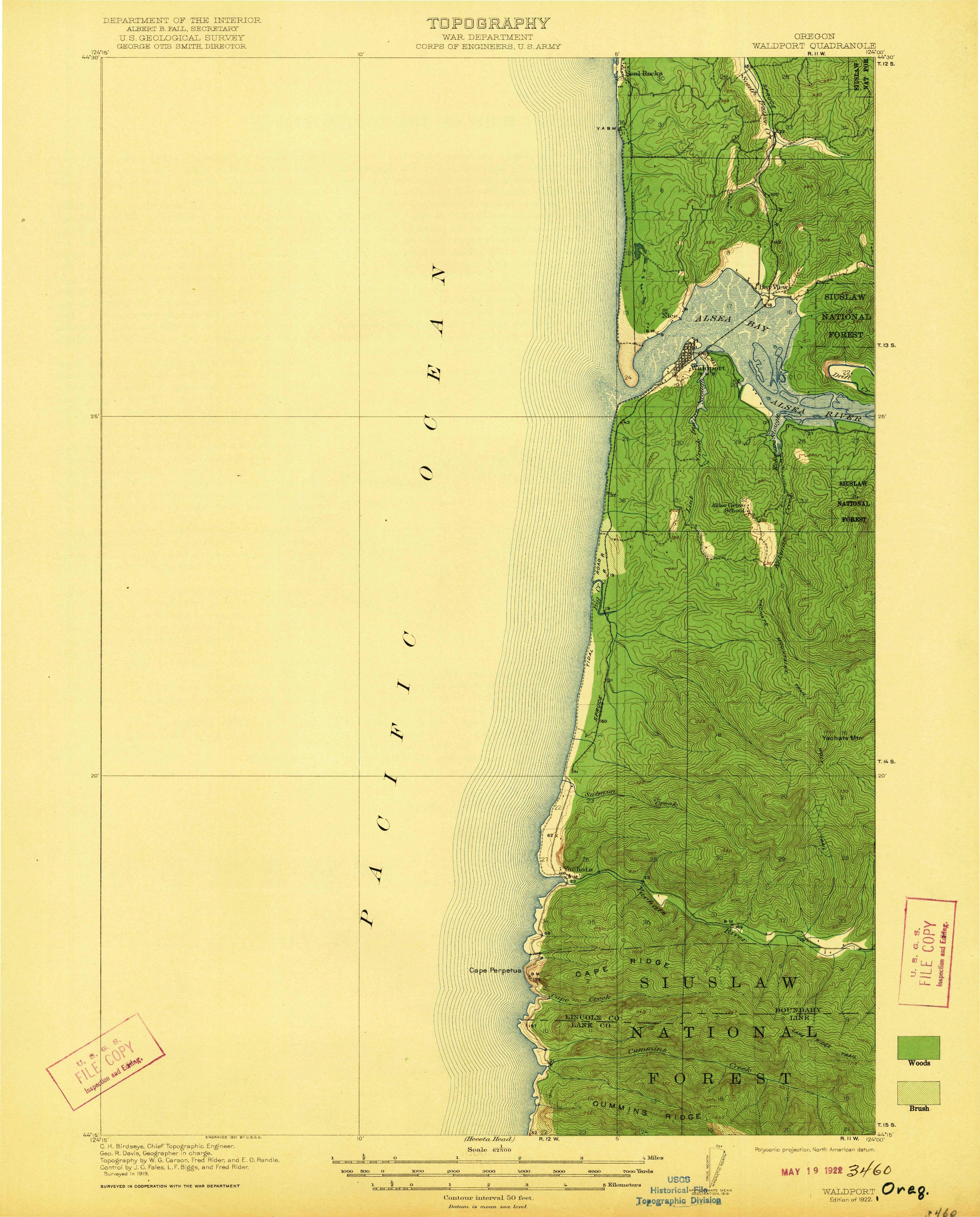
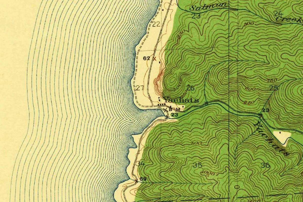
The map at the top is a detail of the Waldport quadrangle. Its header names the Department of the Interior under Albert B. Fall and the Geological Survey under George Otis Smith, and says the topography is by the War Department’s Corps of Engineers. C. H. Birdseye is chief topographic engineer and Geo. R. Davis geographer in charge, with topography by W. G. Carson, Fred Rider and E. O. Randle. The sheet says “Surveyed in 1919,” engraved in 1921, and it’s marked “Edition of 1922,” with a file stamp of May 19, 1922. So this is the original 1922 printing.
In the crop you can see the word Yachats at the settlement and again along the river, with Salmon Creek, a bench mark, section numbers and woods shaded green on the hills. Six years after the post office changed its name, the federal map already used the new one.
Quick answers
How do you pronounce Yachats?
YAH-hots, according to the Oregon Encyclopedia.
What does Yachats mean?
It’s disputed. Oregon State Parks says it’s thought to mean “at the foot of the mountain,” which the Oregon Encyclopedia calls dubious. Other readings include “dark water,” “as far as you can go along the beach” and “where the trail leaves the beach.”
What language is Yachats from?
Ya’xaik is the Alsea name of the village, the Siletz tribes say, and the English spelling grew out of the Coos pronunciation, Yahach.
What was Yachats called before?
Its post office opened as Ocean View in 1887, the Oregon Encyclopedia says. It closed in 1893, came back a few years later farther south, and was renamed Yachats in 1916.
Key dates
- 1859The government makes the site the southern headquarters of the Coast (Siletz) Reservation, the Siletz tribes say.
- 1862Agent Linus Brooks writes the prairie's Indian name as 'Ya-ha-u tah,' from the small river there.
- 1876The area is opened to settlers, by the Siletz tribes' date; the Oregon Encyclopedia says about 1875.
- 1887A post office named Ocean View opens, a mile (1.6 km) or so north of where the river meets the sea.
- 1912The West Coast Construction Company plats a townsite called Yahutes-by-the-Sea, the Oregon Encyclopedia says.
- 1916The Ocean View post office is renamed Yachats.
- 1922The Geological Survey's Waldport quadrangle, surveyed in 1919, is issued with Yachats on it.
- 1967Yachats is incorporated as a city.
Things to do in Yachats, Oregon
Yachats State Recreation Area
A park with a big view, a short walk from the center of town, with a viewing platform over the waves and a steep path down to rocky tide pools at low tide.
Smelt Sands and the 804 Trail
A viewpoint known for tide pools and the smelt run, with the 804 Trail, an old county road right-of-way that local citizens worked 15 years to open for hikers in 1990.
Yachats Ocean Road State Natural Site
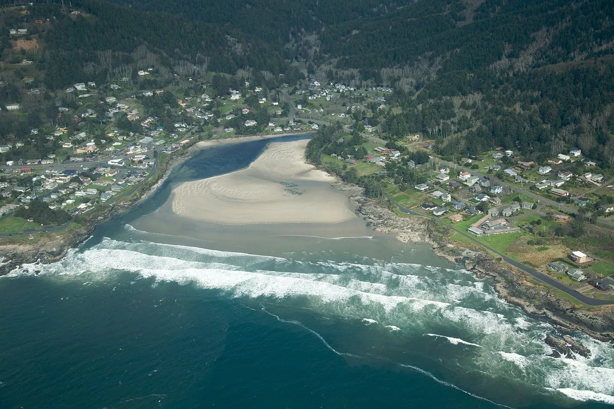
A one-mile (1.6 km) loop road where the Yachats River meets the ocean, with views of Yachats Bay and a broad beach below the town.
Cape Perpetua Scenic Area
A Forest Service area a couple of miles south of town, with 26 miles (42 km) of trails and an 800-foot (244 m) headland. The Forest Service says the Alsea called the area Halaqaik.
Getting there
Open Yachats in Google Maps
Opens in a new tab. The pin is the center of Yachats in the USGS place-name record.
The closest airports, Amtrak stations and intercity bus stops, measured in a straight line from the center of Yachats.
Airports
- Mahlon Sweet Field (EUG) Eugene 46 mi 74 km
- Southwest Oregon Regional (OTH) North Bend 62 mi 100 km
- Portland International (PDX) 115 mi 185 km
Amtrak trains
- Eugene station (EUG) 53 mi 86 km
- Albany station (ALY) 54 mi 87 km
Intercity buses
- Pacific Crest Bus Lines Monroe 40 mi 64 km
- FlixBus Corvallis OR - Oregon State University (CVO) Bus Stop 45 mi 72 km
- Greyhound Corvallis OR - Downtown Transit Center (CVI) 45 mi 73 km
Distances are as the crow flies, not by road. We don't list schedules or fares because they change; check with the airline, Amtrak or the bus company before you go. Official data (FAA commercial service airports (2025), FAA airport locations, Amtrak stations and Intercity Bus Atlas) from the FAA and the U.S. Bureau of Transportation Statistics, checked Nov 18, 2026.
Sponsored
Staying in Yachats?
Compare hotels in Yachats, Oregon, on Expedia.
See hotels in YachatsWe may earn a commission if you buy through this link. It never changes what we write. Read our affiliate disclosure
Historical Sources & References
- Confederated Tribes of Siletz Indians, “Selected English Place Names with Indigenous Origins in Western Oregon” (2025). Ya’xaik, the epidemics, the subagency of 1859, the forced removals, the opening in 1876 and the Coos pronunciation Yahach.
- Joanne Kittel and Suzanne Curtis, The Yaxaik Native People, Origins of the Yachats Name, and the Prison Camp Years, pp. 16-20. The Alsea and Coos forms from Harrington’s notes, Youitts, the agents’ spellings of 1862 to 1872, and the meanings from Hays, Scott, Kentta, Frachtenberg and Pearson.
- Oregon Encyclopedia, “Yachats”. YAH-hots, the subagency, Ocean View in 1887, the rename of 1916, the spellings, the plats, the highway of 1936 and incorporation in 1967.
- Oregon State Parks, Yachats State Recreation Area. “Thought to mean ‘at the foot of the mountain.’” With the Smelt Sands, Yachats Ocean Road and Cape Perpetua pages, the details in the things-to-do list.
- U.S. Geological Survey, GNIS feature 1152681. Yachats in Lincoln County.
- Waldport quadrangle, surveyed 1919, edition of 1922. The sheet the map at the top was cropped from.
Sponsored
Put this 1922 map on your wall
The Geological Survey's 1922 Waldport sheet, surveyed in 1919 with the War Department, with Yachats at the mouth of its river, is in the public domain. Download the full-size scan for free, then have it printed on canvas with CanvasOnTheCheap.
Print a map on canvasDownload the full-size mapWe may earn a commission if you buy through this link. It never changes what we write. Read our affiliate disclosure
Spot something wrong, or know more? Tell us here. You can also email us or use our contact page. Corrections are noted here with their date, never made silently.