What Does Walla Walla Mean? A Word With Many Readings
Walla Walla was the name of a people, a river and a valley before it was a town. Elliott Coues read it as "the small rapid river," Myron Eells as "running water," and Henry Gannett as a rapid stream. The county commissioners gave the name to the town in November 1859.
Walla Walla, Washington, carries a word that writers have read as running water, a small rapid river and ripple after ripple, among other meanings. Each reading comes from a different writer, and the word belonged to a people, then a river and a valley, long before the county commissioners put it on a town in 1859.
More than 20 spellings
The word first reached paper with Lewis and Clark. Edmond S. Meany’s Origin of Washington Geographic Names (1923) quotes Elliott Coues, who edited their journals, on the entries for April 26, 1806: Lewis wrote “Wollah Wollah,” Clark wrote “Wallow Wallows” and elsewhere “Woller Woller,” and the map has “Wollaw Wollah.” Coues added that “more than 20 forms” of this “slippery word” turn up in print. HistoryLink, the online encyclopedia of Washington history, quotes the journals’ “Wallahwollah river” and their “honest and friendly … Wallah wallahs.”
The expedition’s spelling wandered elsewhere too. Down the Columbia in Hood River, Oregon, the stream it called the Labeasche River in 1805 took its name from one of the expedition’s boatmen, Francis Labiche, in what Lewis A. McArthur called an improvised spelling.
What the word means
Here’s where the readings split. Coues, in the same note, wrote that “In several languages walla means running water, and reduplication of word diminutizes it; so Wallawalla is the small rapid river.”
Myron Eells, a missionary’s son who spent his life working among Native people, published another explanation in the American Anthropologist in January 1892, and Meany quotes it: “Walla Walla is a Nez Perce and Cayuse word, the root of which is walatsa, which means ‘running’; hence ‘running water’.” Eells gave two meanings, “‘a small stream running into a large one’” and “‘ripple after ripple’, ‘fall after fall’,” and said he’d had them from P. M. Whitman and Dr. W. C. McKay, two men who spoke the Walla Walla language. So that’s one writer passing on what two others told him.
The ethnographer Edward S. Curtis, again by way of Meany, said the Nez Perce called the Walla Walla people “Walawalapu, ‘Little River People’.” Henry Gannett, who gathered the origins of American place names for the Geological Survey, kept it to a few words in 1905: “From a Nez Perce Indian word used to designate a rapid stream.”
Newer sources lean on the same ideas. HistoryLink calls Walla Walla a Nez Perce name for one of the valley’s Native groups and gives the meaning as “running waters,” or the spot where a small stream meets a larger one. Downtown, the Downtown Walla Walla Foundation says the plaza it helped build with the city, finished in May 2023, is named Walawála, “many small streams” in the Sahaptin language. The Confederated Tribes of the Umatilla Indian Reservation, which joined the Cayuse, Umatilla and Walla Walla peoples, gave advice on its design, the foundation says.
Fort, mission and treaty
The name spread from the people to the places. Meany notes that Fort Nez Perces, put up by the North West Company near the river’s mouth in 1818, came to be called “Old Fort Walla Walla.” In 1836, HistoryLink says, Marcus and Narcissa Whitman founded their mission among the Cayuse at Waiilatpu, about seven miles (11 km) west of the present city. HistoryLink’s thumbnail history of the city translates Waiilatpu as “the place of the rye grass” in Cayuse. In 1847, HistoryLink says, the Whitmans and others at the mission were killed by Cayuse men.
The territorial legislature organized Walla Walla County on April 25, 1854. On June 9, 1855, Governor Isaac Stevens and Joel Palmer signed a treaty with the “Walla-Walla, Cayuses, and Umatilla Tribes,” at “Camp Stevens, in the Walla Walla valley,” a site Meany places inside the present city. Stevens’s treaties that June also named the Yakama in Yakima, another name with several translations in Meany’s book. The war that followed brought Lt. Col. Edward J. Steptoe, who set up a new Fort Walla Walla in 1856. HistoryLink puts that post in what’s now downtown.
Steptoeville, Wieletpu, Walla Walla
The town that grew next to Steptoe’s fort went through three names in a single year. Meany quotes the History of Southeastern Washington: the first county commissioners met on March 15 and 26, 1859, and called the place Walla-Walla. Later minutes called it Steptoeville, and on July 2 the board voted that “the name of the town of Steptoeville was changed to Wieletpu.” In September the minutes still said Steptoeville. Then, at the November meeting, “the town of Wieletpu was changed to Walla-Walla.”
That account gives the date as November 7. HistoryLink’s essay dates the naming November 17, 1859, and spells the earlier name “Wailetpu.” Neither says where Wieletpu came from.
The legislature incorporated Walla Walla by an act approved January 11, 1862, and HistoryLink says it became the county seat that same month. You’ve probably also heard it called “the town they liked so well, they named it twice”; HistoryLink’s thumbnail history credits that line to Al Jolson.
In Washington, Meany counted the name among the state’s best-established Native names, and he found the same meaning in Wallula, the town at the river’s mouth where the first Fort Walla Walla stood, only in the Walla Walla language instead of Nez Perce. Across the Oregon line, in Pendleton, the Confederated Tribes run the Tamástslikt Cultural Institute.
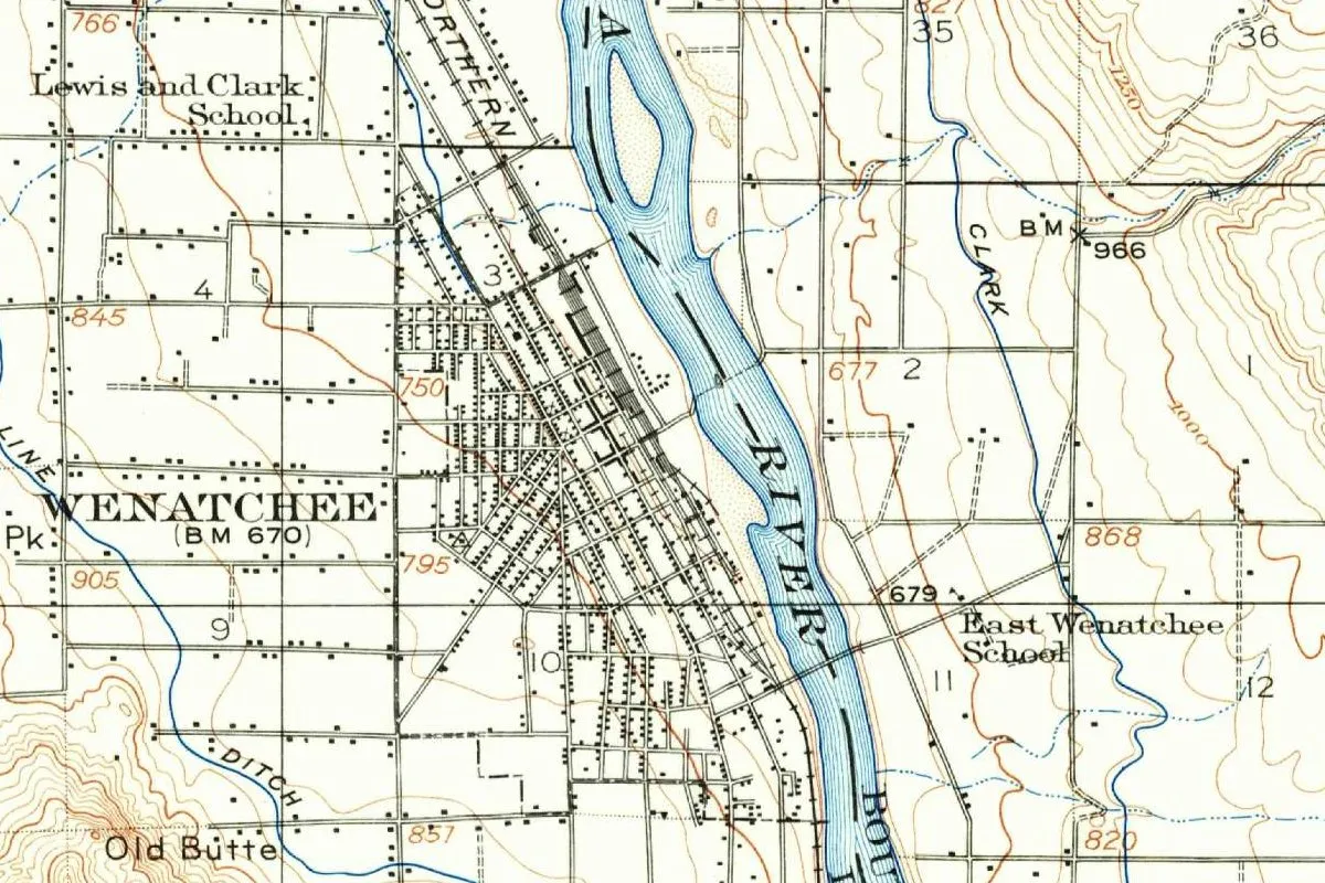
Walla Walla on the 1919 map
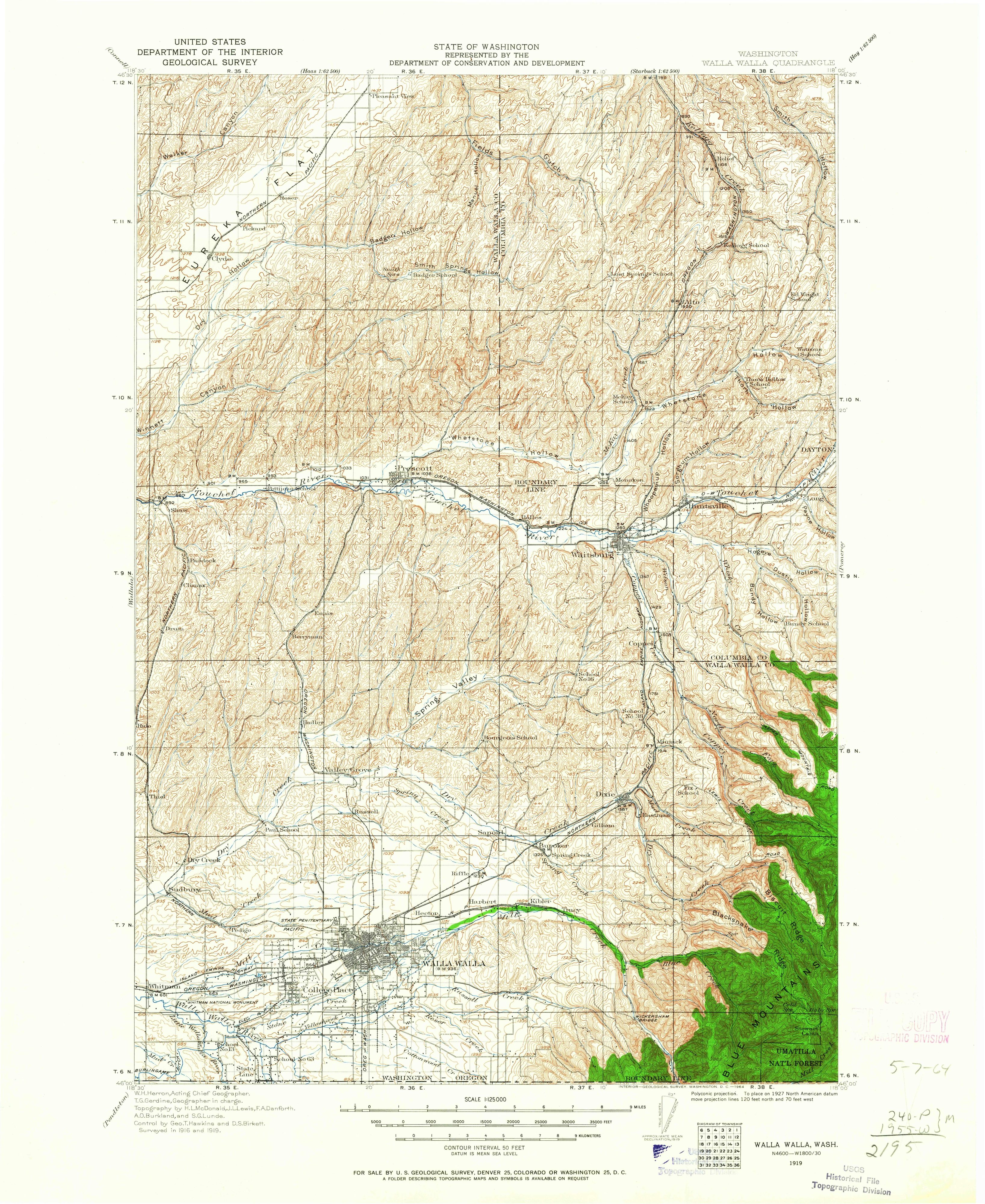
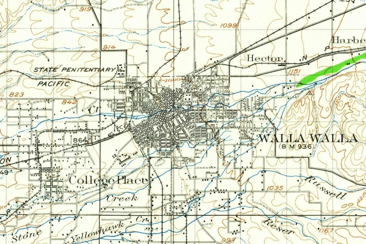
The map at the top of this page comes from the U.S. Geological Survey’s Walla Walla sheet at 1:125,000, made with the State of Washington’s Department of Conservation and Development. Its margin names W. H. Herron as acting chief geographer and T. G. Gerdine as geographer in charge, with topography by H. L. McDonald, J. L. Lewis, F. A. Danforth, A. O. Burkland and S. G. Lunde, and says the area was “Surveyed in 1916 and 1919.” The sheet is the 1919 edition, but the printer’s line reads “WASHINGTON, D. C.—1964,” so this copy was printed in 1964.
In the detail, you’ll see the street grid of Walla Walla with bench mark 936, College Place to the southwest and the STATE PENITENTIARY to the northwest. Railroad lines marked PACIFIC and N P run through, Hector and Harbert sit to the northeast, and Yellowhawk, Stone, Russell and Reser creeks cross the fields to the south. Contour lines are drawn every 50 feet (15 m).
Quick answers
What does Walla Walla mean?
The sources disagree. Elliott Coues gave “the small rapid river,” Myron Eells “running water” with two senses, Henry Gannett “a rapid stream,” and the Downtown Walla Walla Foundation gives “many small streams” for Walawála.
What was Walla Walla called before?
In 1859 the county commissioners’ minutes called it Steptoeville and, for a few months, Wieletpu.
When did Walla Walla get its name?
At the commissioners’ November 1859 meeting, on the 7th by the county history Meany quotes and on the 17th by HistoryLink.
Key dates
- 1806Lewis and Clark's journals record the name in several spellings, among them Wollah Wollah and Woller Woller.
- 1818The North West Company builds Fort Nez Perces near the mouth of the Walla Walla River, later called Old Fort Walla Walla.
- 1836Marcus and Narcissa Whitman found their mission at Waiilatpu, about 7 miles (11 km) west of the present city.
- 1854The territorial legislature organizes Walla Walla County on April 25.
- 1855On June 9, a treaty with the Walla Walla, Cayuse and Umatilla is signed at "Camp Stevens, in the Walla Walla valley."
- 1856Lt. Col. Edward J. Steptoe sets up a new Fort Walla Walla; a town grows up near it.
- 1859The county commissioners record the town as Walla-Walla, then Steptoeville, then Wieletpu, and finally Walla Walla again in November.
- 1862Walla Walla is incorporated by an act approved January 11 and becomes the county seat.
- 2023Walawála Plaza opens downtown, its name given as "many small streams" in Sahaptin.
Things to do in Walla Walla, Washington
Whitman Mission National Historic Site
The site of the Whitman mission at Waiilatpu, west of town, where you can look over the mission grounds and the valley from Monument Hill and watch a 25-minute film at the visitor center.
Fort Walla Walla Museum
A history museum on the grounds of a 19th-century army fort, with five exhibit halls, a wheat harvest pulled by 33 mules, a cell from the state penitentiary, Washington's oldest surviving locomotive and a pioneer village of 17 buildings.
Kirkman House Museum
The brick Italianate house William and Isabella Kirkman built in 1880 on North Colville Street, with restored Victorian rooms and exhibits on local history.
Walawála Plaza
A downtown gathering place designed with guidance from the Confederated Tribes of the Umatilla Indian Reservation; the foundation that helped build it gives its name as "many small streams" in Sahaptin.
Getting there
Open Walla Walla in Google Maps
Opens in a new tab. The pin is the center of Walla Walla in the USGS place-name record.
The closest airports, Amtrak stations and intercity bus stops, measured in a straight line from the center of Walla Walla.
Airports
- Walla Walla Regional (ALW) 3 mi 6 km
- Tri-Cities (PSC) Pasco 40 mi 64 km
Amtrak trains
- Pasco station (PSC) 38 mi 60 km
Intercity buses
- Grape Line Travel Washington · Valley Transit under 1 mi 0.2 km
- Northwestern Stage Lines Pendleton 35 mi 56 km
- FlixBus Pasco Bus Stop 38 mi 60 km
Distances are as the crow flies, not by road. We don't list schedules or fares because they change; check with the airline, Amtrak or the bus company before you go. Official data (FAA commercial service airports (2025), FAA airport locations, Amtrak stations and Intercity Bus Atlas) from the FAA and the U.S. Bureau of Transportation Statistics, checked Nov 18, 2026.
Sponsored
Staying in Walla Walla?
Compare hotels in Walla Walla, Washington, on Expedia.
See hotels in Walla WallaWe may earn a commission if you buy through this link. It never changes what we write. Read our affiliate disclosure
Historical Sources & References
- Edmond S. Meany, Origin of Washington Geographic Names (1923), pp. 332-333. Coues on the Lewis and Clark spellings, Eells and Curtis on the meaning, Fort Nez Perces, the county, the 1855 treaty, Steptoe, the 1859 minutes, incorporation and Wallula. Checked against the page image.
- Michael J. Paulus Jr., HistoryLink Essay 8478. The Nez Perce name, “running waters,” the 1806 journals, Fort Nez Perces, the Whitman mission, Steptoe’s fort, the naming in November 1859 and incorporation in 1862.
- HistoryLink Essay 8486, Walla Walla thumbnail history. Waiilatpu as “the place of the rye grass” and the Al Jolson line.
- Henry Gannett, The Origin of Certain Place Names in the United States (1905), p. 313. The Nez Perce word for a rapid stream.
- Confederated Tribes of the Umatilla Indian Reservation, “History & Culture”. The Cayuse, Umatilla and Walla Walla peoples and the treaty of 1855.
- Downtown Walla Walla Foundation, “About Us”. Walawála Plaza, “many small streams,” and the Tribes’ part in its design.
- Whitman Mission National Historic Site, Fort Walla Walla Museum and Kirkman House Museum. The places listed above.
- Walla Walla’s GNIS entry, feature 1512769 (U.S. Geological Survey). The city’s listing as a populated place in Walla Walla County, with its coordinates.
- U.S. Geological Survey, Walla Walla sheet (edition of 1919, printed 1964). The 1:125,000 sheet the map at the top was cropped from.
Sponsored
Put this 1919 map on your wall
The Geological Survey's Walla Walla sheet, surveyed in 1916 and 1919 with the State of Washington and shown here in a 1964 printing, is in the public domain. Download the full-size scan for free, then have it printed on canvas with CanvasOnTheCheap.
Print a map on canvasDownload the full-size mapWe may earn a commission if you buy through this link. It never changes what we write. Read our affiliate disclosure
Spot something wrong, or know more? Tell us here. You can also email us or use our contact page. Corrections are noted here with their date, never made silently.