McCall, Idaho: Tom McCall's Town and Its Neighbor, Lardo
McCall is named for Tom McCall, who settled at the south end of Payette Lake in 1889. The McCall Area Chamber of Commerce says citizens chose the name to honor him as 'the father of the town.' Lardo, the name sometimes used for the area, belonged to a separate settlement a mile west, according to the Payette River Scenic Byway.
McCall, Idaho, honors Tom McCall, a settler who traded a wagon and a team for a lakeshore claim in 1889, though local histories disagree about Lardo. The town’s own visitors bureau says citizens picked “McCall” to honor Tom “as the father of the town.” The harder question is Lardo.
A wagon for a lakeshore claim
The McCall Area Chamber of Commerce tells the family story in some detail. Tom and Louisa McCall, an emigrant family from Ohio and Missouri, were nearing their 50s when they headed west. They reached Boise in 1888, and in the spring of 1889 they set off for Long Valley with three sons, two wagons, 25 head of cattle, numerous chickens and household supplies.
When they pulled in at the south end of Payette Lake that June, they found a single resident, Sam Devers, who held squatter’s rights to 160 acres (65 ha) of shoreline. He was eager to move on, the chamber says, and traded his rights and his cabin to Tom for “a wagon, team and harness.” The spot is where the Hotel McCall stands today. Tom then laid out a town site of four blocks from his homestead.
The Payette River Scenic Byway’s history puts the trade “around 1890” and says the McCalls ran the homestead as a place for miners to get room and board on their way to camps such as Warren. Valley County’s history has the date as 1889, though it gives the settler’s first name as Louis. If you’ve read about St. Cloud, Minnesota, where the man who platted the town paid a squatter $250 for his right to the land, or Cedar Rapids, Iowa, where N. B. Brown and his partners bought out a squatter before the surveying began, the move will sound familiar.
Lardo, two ways
Here’s where the local histories split. In the chamber’s version, Lardo was a name the McCall settlement borrowed for a while. “In the early days Tom McCall appropriated the abandoned Lardo U.S. Post Office, originally located ten miles south of the lake, and the area was briefly known as ‘Lardo.’” Then, in 1903, W. B. Boydstun took over the post office and moved it, name and all, to his homestead west of the river. That’s when, the chamber says, citizens changed the name to McCall.
The byway’s history describes two towns instead of one. “Lardo, located a mile west of the McCall place, was a small but thriving community predating the establishment of McCall,” it says, and both places had post offices. When Tom McCall’s sawmill burned in 1896, it was rebuilt in Lardo, and when Lardo’s mill burned in 1905, a new one went up in McCall. The friendly rivalry lasted, and “‘Lardo’ was often used to describe both communities until Lardo’s post office was moved to the newly incorporated McCall in 1917.”
Valley County’s history adds that a post office opened at Lardo in 1889 with John Lane as postmaster, and that W. H. Boydstun set up a freight stop there for the mines at Warren Meadows. So the sources agree that there was a Lardo, and that the town by the lake ended up as McCall. They don’t agree on whether Lardo was ever the town’s own name.
Two names on the 1911 map
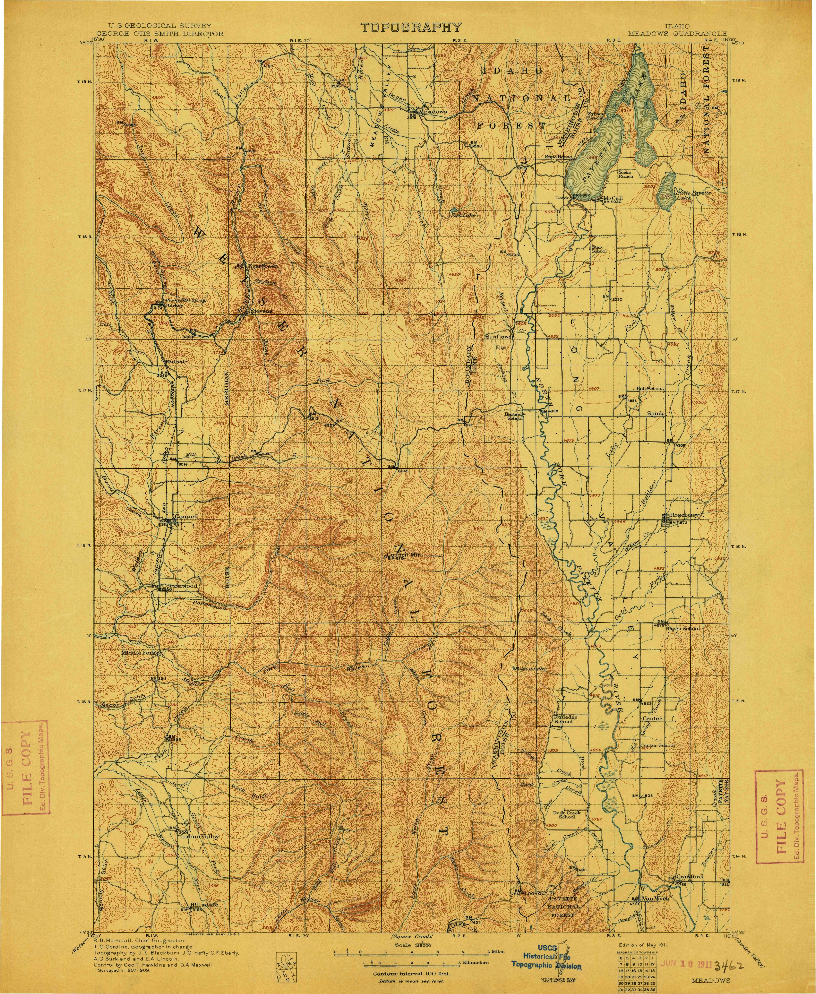
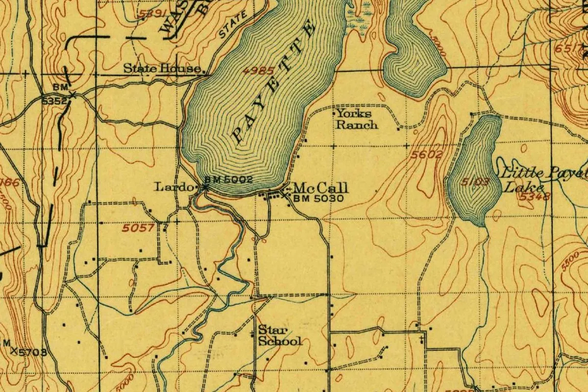
The map at the top of this page is the Geological Survey’s Meadows quadrangle, surveyed in 1907-1909 and issued in May 1911, the same year McCall was incorporated. It shows you both names at once. “McCall” sits on the south shore of Payette Lake, by a benchmark at 5030 feet (1,533 m). “Lardo” sits off to the west, right where the river leaves the lake, by its own benchmark at 5002 feet (1,525 m).
Two names, two benchmarks. Whatever the town had been called before, by 1911 the Geological Survey’s mapmakers treated Lardo and McCall as separate places.
The father of the town
Tom McCall wore a lot of hats. The chamber lists him as “landowner, realtor, hotel owner, postmaster, sawmill owner, merchant, and councilman.” When the Payette Forest Reserve was created in 1905, its headquarters were in Meadows. Tom got them moved to McCall in 1908, the chamber says, by offering office space in his new building and paying the supervisor’s $80 moving bill. His son Daws became the ranger for what’s now the McCall Ranger District.
The Town of McCall was incorporated on July 19, 1911. Another Idaho town that carries one man’s name is Kellogg, named for N. S. Kellogg, who found the Bunker Hill mine.
Quick answers
Who is McCall, Idaho, named after?
Tom McCall, who settled at the south end of Payette Lake in 1889 with his wife, Louisa. The McCall Area Chamber of Commerce says citizens named the town to honor him “as the father of the town.”
Was McCall, Idaho, once called Lardo?
It depends on the source. The chamber of commerce says the area was “briefly known as ‘Lardo’” before the post office moved west in 1903. The Payette River Scenic Byway says Lardo was a separate community a mile west, and that the name was often used for both until 1917.
When was McCall, Idaho, incorporated?
On July 19, 1911, according to the McCall Area Chamber of Commerce.
Key dates
- 1889June: Tom and Louisa McCall trade for Sam Devers's claim at Payette Lake, per the chamber of commerce. Valley County dates a Lardo post office to the same year.
- 1903W. B. Boydstun moves the Lardo post office and its name to his homestead west of the river, according to the chamber of commerce.
- 1908Tom McCall gets the forest reserve's headquarters moved from Meadows to McCall.
- 1911The Town of McCall is incorporated on July 19.
- 1917Lardo's post office moves to McCall, according to the Payette River Scenic Byway.
Things to do in McCall, Idaho
Ponderosa State Park
A state park of 1,515 acres (613 ha) on Payette Lake, with a Peninsula Unit surrounded by the lake and a North Beach Unit on its shore, trails for hiking and biking, naturalist programs, campsites and cabins, according to Idaho State Parks.
Legacy Park
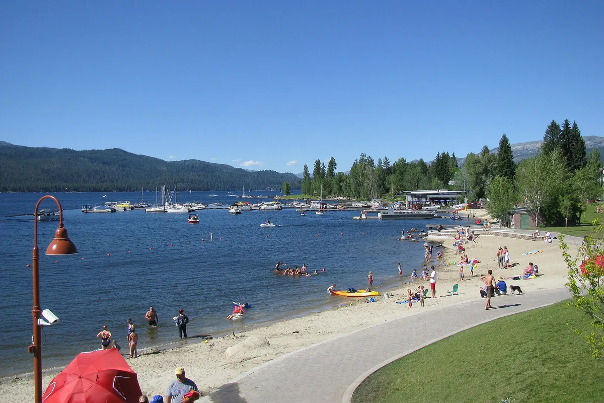
The city's park near the downtown shopping area, at the bend north of Hotel McCall on East Lake Street, with a beach, an enclosed swimming area, a volleyball court, picnic tables and a public boat ramp.
Central Idaho Historical Museum
A four-acre (1.6 ha) site in McCall with eight historic structures built in 1937 by the Civilian Conservation Corps and listed on the National Register of Historic Places, which the museum says tell the story of the town's timber heritage.
Brundage Mountain
A ski area 8 miles (13 km) north of McCall, with 1,920 acres (777 ha) of lift-accessed terrain, 70 named trails and a summit at 7,803 feet (2,378 m), according to the resort.
Getting there
Open McCall in Google Maps
Opens in a new tab. The pin is the center of McCall in the USGS place-name record.
The closest airports, Amtrak stations and intercity bus stops, measured in a straight line from the center of McCall.
Airports
- Boise Air Trml/Gowen Field (BOI) 93 mi 150 km
- Lewiston/Nez Perce County (LWS) 110 mi 178 km
Intercity buses
- Northwestern Stage Lines McCall under 1 mi 1 km
Distances are as the crow flies, not by road. We don't list schedules or fares because they change; check with the airline, Amtrak or the bus company before you go. Official data (FAA commercial service airports (2025), FAA airport locations, Amtrak stations and Intercity Bus Atlas) from the FAA and the U.S. Bureau of Transportation Statistics, checked Nov 17, 2026.
Sponsored
Staying in McCall?
Compare hotels in McCall, Idaho, on Expedia.
See hotels in McCallWe may earn a commission if you buy through this link. It never changes what we write. Read our affiliate disclosure
Historical Sources & References
- McCall Area Chamber of Commerce, “Historic Information”. Tom and Louisa McCall, the 1889 trade with Sam Devers, the Lardo post office and Boydstun in 1903, “Honoring Tom as the father of the town,” the incorporation of July 19, 1911, and the forest headquarters of 1908.
- Payette River Scenic Byway, “History”. The trade “around 1890,” Lardo “a mile west of the McCall place,” the sawmill fires of 1896 and 1905, and the post office move of 1917.
- Valley County, “History of Valley County”. “Louis McCall” in 1889, and the Lardo post office and freight stop.
- Ponderosa State Park; Legacy Park; Central Idaho Historical Museum; Brundage Mountain. The details in the things-to-do list, including the 8 miles (13 km) to Brundage and its summit at 7,803 feet (2,378 m).
- GNIS feature 396862 (U.S. Geological Survey). McCall’s listing as a populated place in Valley County, with its coordinates.
- U.S. Geological Survey, Meadows quadrangle (May 1911). The 1:125,000 sheet the map at the top was cropped from, with McCall and Lardo labeled separately.
Sponsored
Put this 1911 map on your wall
The Geological Survey's 1911 Meadows sheet, which shows McCall and Lardo at the foot of Payette Lake, is in the public domain. Download the full-size scan for free, then have it printed on canvas with CanvasOnTheCheap.
Print a map on canvasDownload the full-size mapWe may earn a commission if you buy through this link. It never changes what we write. Read our affiliate disclosure
Spot something wrong, or know more? Tell us here. You can also email us or use our contact page. Corrections are noted here with their date, never made silently.