Stockbridge, Massachusetts: An English Name for Indian Town
Stockbridge was named for Stockbridge in England. The township was granted to the Housatonic, or Mohican, people in 1734, and the settlement known as Indian Town was incorporated under its new name in 1739, John Hayward wrote in 1847. Elias Nason gives June 22, 1739, and says it 'may have been' named from Stockbridge in Hampshire.
Stockbridge, Massachusetts, began as a Mohican mission called Indian Town, and in 1739 it was incorporated under the name of a town in England. The name stuck to more than the town. From then on, as one 1847 gazetteer put it, the Mohican people who lived there were known as the Stockbridge Indians.
Indian Town on the Housatonic
The story starts with a council. According to the Mohican history walking tour of Main Street, written with the Stockbridge-Munsee Community, Mohican sachems met for four days in 1734 and sealed their agreement to a mission with a wampum belt. The Trustees, who own the old Mission House, give the Mohican village’s name as Wnahtukook, and say the missionary John Sergeant arrived there in 1734.
The colony followed with land. The walking tour says that on March 17, 1735, the legislature granted a township six miles (9.7 km) square on the Housatonic River, north of Monument Mountain. A royal charter in 1737 set aside a sixtieth share each for Sergeant, a schoolmaster and four English families, or 2,304 of the township’s 23,040 acres (932 of 9,324 ha). About 125 Mohicans lived there at first, by the tour’s count.
John Hayward’s Gazetteer of Massachusetts sums it up from the colonists’ side: “This township was granted to the River or Housatonic Indians in 1734.” His list of the town’s ministers starts Sergeant’s pastorate in 1735, and he dates the mission church to 1734. Elias Nason, writing in 1874, says the place’s “Indian name was Housatonic,” and that the mission was begun by “the Rev. John Sargeant and Mr. Timothy Woodbridge.”
An English name in 1739
Nobody in these sources says who chose the name. What they do say is where it came from: a town in England. Hayward’s 1847 entry puts it in one sentence:
“…in 1739, the settlement called ‘Indian Town’ was incorporated by its present name, from a town in England; and from that time to the present, the people of this tribe have been called the ‘Stockbridge Indians.’” (Hayward, p. 279)
Nason adds a date and a county, with a little less certainty: Stockbridge “was incorporated June 22, 1739; and may have been named from Stockbridge in Hampshire County, Eng.” Electa F. Jones, whose 1854 history of the town is subtitled Records of an Old Mission Station, was surer of herself. The town, she wrote, was “named; doubtless, from Stockbridge in England, which it strikingly resembles.” That resemblance is her opinion, not something the other books repeat.
Jones also says Ephraim Williams and Josiah Jones moved “to Stockbridge, as it is now called, early in June of 1737.” Note the “as it is now called.” She’s using the later name for a place that, by Hayward’s account, was still Indian Town.
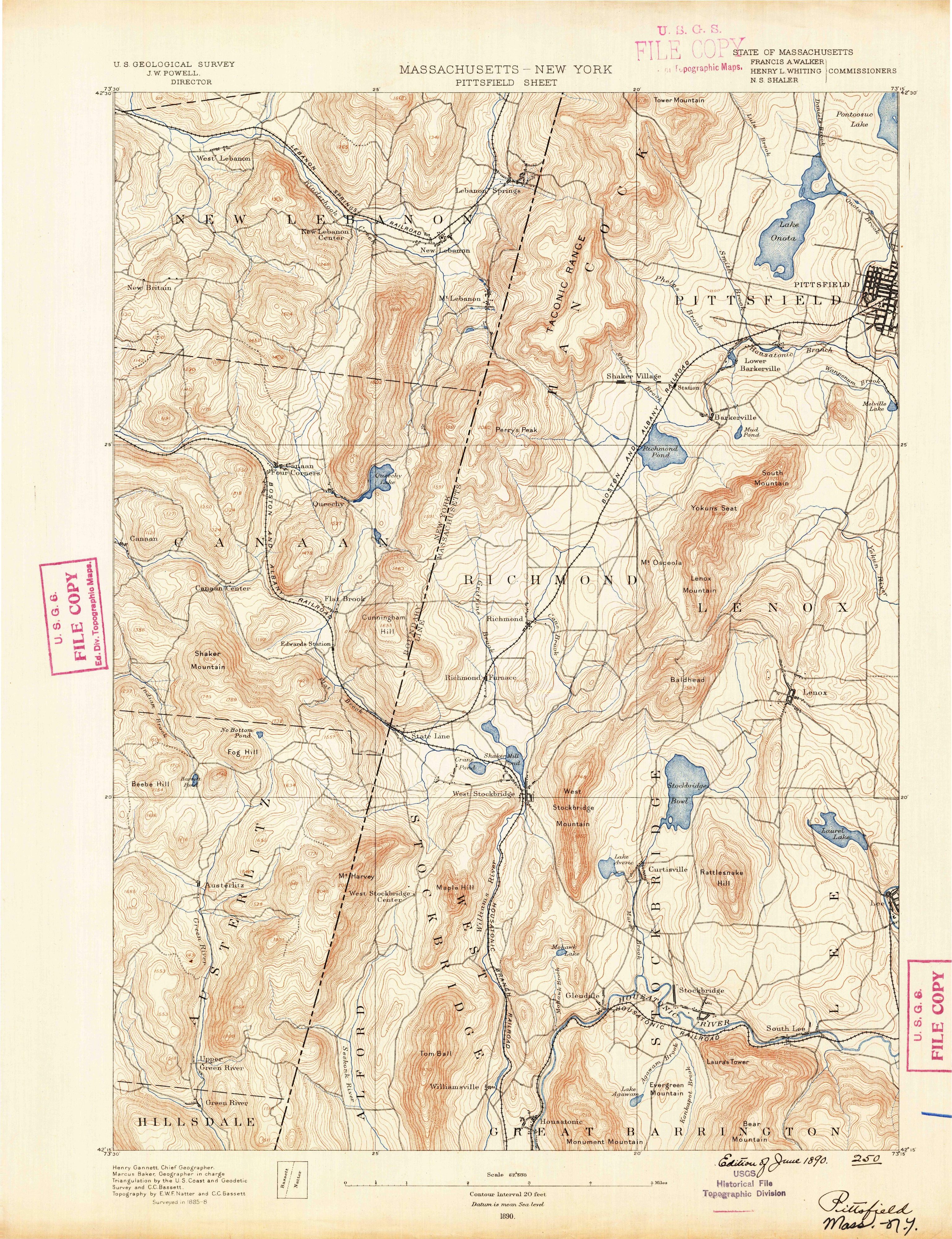
Henry Gannett, who put together the Geological Survey’s 1905 inventory of American names, gave the town one line: “named from Stockbridge in England.” His name also turns up in the margin of the map at the top of this page, as the Survey’s chief geographer. The national names database puts the town in Berkshire County, Massachusetts, and it isn’t the state’s only borrowed English name: Plymouth got its name from an English port, written on John Smith’s map by Prince Charles.
A name that traveled with the Mohicans
The English name ended up belonging to the Mohican people as much as to the town. Jonathan Edwards took over the mission in 1751 and stayed until 1758, Nason says. Hayward writes that the Stockbridge Indians began moving to Oneida County, New York, in 1783, and Nason says they later went on to a “New Stockbridge” in Wisconsin.
They’re still there. The walking tour describes today’s Stockbridge-Munsee Community as a federally recognized nation with a reservation in northern Wisconsin and about 1,500 members. The Munsee half of that name belongs to a Delaware people, the same people Muncie, Indiana, is named for. And the Mohican homeland reached well beyond the Berkshires: the city of Schenectady, New York, says that if anyone lived in the immediate area, it was most likely the Mohican.
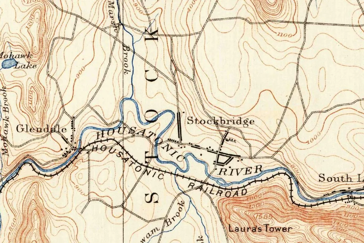
If you look at the Mission House in the photo below, you’re not seeing it where it was built. The Trustees say Sergeant built it around 1742 on Prospect Hill. Mabel Choate had it taken apart, moved and restored on Main Street between 1926 and 1930, when it opened as a museum.
Stockbridge on the 1890 map
The map at the top comes from the Geological Survey’s Pittsfield sheet, covering parts of Massachusetts and New York. The header names J. W. Powell as director and the State of Massachusetts as a partner, with Francis A. Walker, Henry L. Whiting and N. S. Shaler as commissioners. Henry Gannett is chief geographer and Marcus Baker geographer in charge. The topography is by E. W. F. Natter and C. C. Bassett, and the sheet says “Surveyed in 1885-8.” This scan is a Survey file copy with “1890” printed under the scale and a handwritten note, “Edition of June 1890.” There’s no later printing line.
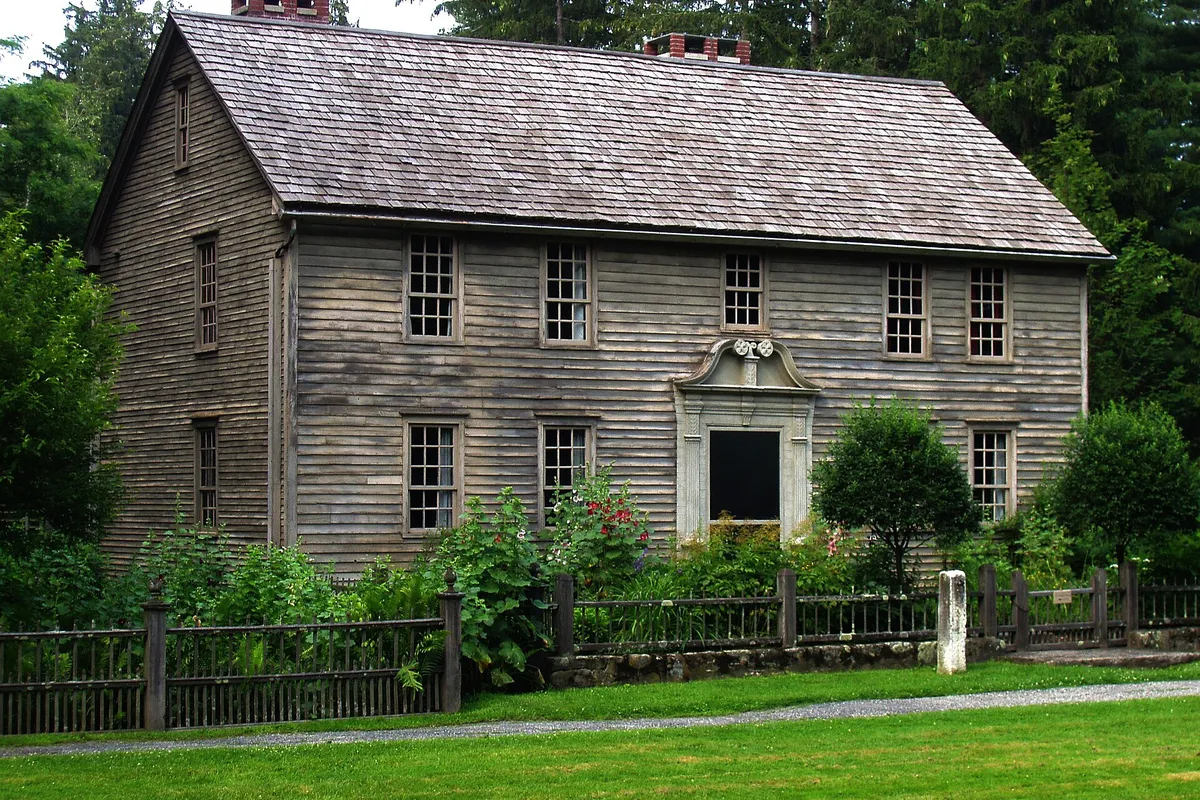
In the crop you can see the village of Stockbridge beside the Housatonic River, with HOUSATONIC RIVER and HOUSATONIC RAILROAD lettered along the valley. The big spaced letters S T O C K are the first half of the town’s name. Glendale sits to the west, near Mohawk Lake and Mohawk Brook, and Laura’s Tower is marked on the hill to the south, the same tower the Laurel Hill Association’s trail climbs to today.
Quick answers
Who is Stockbridge named after?
Nobody. It’s named for a place: Stockbridge in England, according to Hayward (1847), Jones (1854) and Gannett (1905). Nason (1874) says it “may have been” Stockbridge in Hampshire.
When did Stockbridge get its name?
In 1739, when the settlement known as Indian Town was incorporated as a town. Nason gives the date as June 22, 1739.
What was Stockbridge called before?
Indian Town, Hayward says. Nason gives its Indian name as Housatonic, and the Trustees call the Mohican village Wnahtukook.
Why are the Mohicans called the Stockbridge Indians?
After the 1739 incorporation, Hayward writes, the people of the mission “have been called the ‘Stockbridge Indians.’” Today they’re the Stockbridge-Munsee Community in Wisconsin.
Key dates
- 1734Mohican sachems hold a four-day council and agree to a mission; the township is granted to the Housatonic people, Hayward says.
- 1735On March 17 the legislature grants a township six miles (9.7 km) square on the Housatonic, by the walking tour's account.
- 1737A royal charter sets aside shares for John Sergeant, the schoolmaster and four English families.
- 1739Indian Town is incorporated as Stockbridge, on June 22 by Nason's date.
- 1742John Sergeant builds the Mission House, about this year by the Trustees' account.
- 1751Jonathan Edwards takes up the Stockbridge mission.
- 1783The Stockbridge Indians begin moving to Oneida County, New York, Hayward writes.
- 1890The Geological Survey issues its Pittsfield sheet in an edition of June 1890, with Henry Gannett as chief geographer.
- 1905Gannett writes that the town was named from Stockbridge in England.
Things to do in Stockbridge, Massachusetts
Mohican History Walking Tour of Main Street
A self-guided walk created by the Stockbridge-Munsee Community that tells the Mohican story of Main Street, from the council of 1734 to the people's later moves west.
Stockbridge Library Museum & Archives
The town library's history department, with artifacts, photographs, deeds, maps and ledgers on Stockbridge and its families, building on a historical collection the library recorded as early as 1865.
Chesterwood
The summer estate of the sculptor Daniel Chester French, now run by the National Trust for Historic Preservation, with his studio, a Colonial Revival residence, gardens and woodland walks.
Laura's Tower Trail
A trail kept by the Laurel Hill Association that climbs about 600 feet (183 m) to a metal tower on the summit, with views that reach Mount Greylock.
Getting there
Open Stockbridge in Google Maps
Opens in a new tab. The pin is the center of Stockbridge in the USGS place-name record.
The closest airports, Amtrak stations and intercity bus stops, measured in a straight line from the center of Stockbridge.
Airports
- Albany International (ALB) 40 mi 65 km
- Bradley International (BDL) Windsor Locks 41 mi 65 km
Amtrak trains
- Pittsfield station (PIT) 12 mi 19 km
- Hudson station (HUD) 25 mi 39 km
Intercity buses
- Peter Pan (BZ) Peter Pan Bus Lines · Stockbridge under 1 mi 1 km
- OurBus Lee - Berkshires, MA (Lee Service Plaza Wesbound- the bus will stop in the area designated for trucks and buses. The bus may take a 10 to 20 minute rest stop here, at the driver's discretion.) 2 mi 4 km
- Greyhound Lee Mobil Gas Station 4 mi 6 km
Distances are as the crow flies, not by road. We don't list schedules or fares because they change; check with the airline, Amtrak or the bus company before you go. Official data (FAA commercial service airports (2025), FAA airport locations, Amtrak stations and Intercity Bus Atlas) from the FAA and the U.S. Bureau of Transportation Statistics, checked Nov 18, 2026.
Sponsored
Staying in Stockbridge?
Compare hotels in Stockbridge, Massachusetts, on Expedia.
See hotels in StockbridgeWe may earn a commission if you buy through this link. It never changes what we write. Read our affiliate disclosure
Historical Sources & References
- John Hayward, A Gazetteer of Massachusetts (1847), pp. 278-280. The grant of 1734, “Indian Town” incorporated in 1739 “by its present name, from a town in England,” the “Stockbridge Indians,” Sergeant and Edwards, and the move to Oneida County from 1783. Checked against the page image.
- Elias Nason, A Gazetteer of the State of Massachusetts (1874), p. 483. “Whose Indian name was Housatonic,” incorporated June 22, 1739, “may have been named from Stockbridge in Hampshire County, Eng.,” Sargeant and Woodbridge, Edwards and New Stockbridge. Checked against the page image.
- Electa F. Jones, Stockbridge, Past and Present (1854), p. 57. The move of June 1737 and “named; doubtless, from Stockbridge in England, which it strikingly resembles.” Checked against the page image.
- Henry Gannett, The Origin of Certain Place Names in the United States (1905), p. 291. “Named from Stockbridge in England.”
- Native American Heritage Trail, Mohican History Walking Tour. The council of 1734, the grant of March 17, 1735, the charter of 1737 and its shares, the first population and today’s Stockbridge-Munsee Community.
- The Trustees, “The Mission House”. Wnahtukook, Sergeant’s arrival, the house of about 1742 and its move from Prospect Hill between 1926 and 1930.
- Stockbridge Library Museum & Archives; Chesterwood; Laurel Hill Association, Laura’s Tower Trail. The details in the things-to-do list.
- U.S. Geological Survey, GNIS feature 607749. Where the national names database puts the town, in Berkshire County.
- Pittsfield sheet, surveyed 1885–88, edition of June 1890. The sheet the map at the top was cropped from, with triangulation by the U.S. Coast and Geodetic Survey and C. C. Bassett.
Sponsored
Put this 1890 map on your wall
The Geological Survey's 1890 Pittsfield sheet, surveyed in 1885-88, with Stockbridge on the Housatonic River, is in the public domain. Download the full-size scan for free, then have it printed on canvas with CanvasOnTheCheap.
Print a map on canvasDownload the full-size mapWe may earn a commission if you buy through this link. It never changes what we write. Read our affiliate disclosure
Spot something wrong, or know more? Tell us here. You can also email us or use our contact page. Corrections are noted here with their date, never made silently.