Paw Paw, Michigan: Named for a River and Its Pawpaws
Paw Paw takes its name from the Paw Paw River. The 1880 History of Berrien and Van Buren Counties says Indians named the river "from the paw paw fruit, growing thickly upon its banks," and that Peter Gremps and Lyman J. Daniels laid out a village they called Paw Paw after buying a sawmill there in 1833.
Paw Paw, Michigan, took its name from the river it sits on, and the river, an 1880 county history says, was named for the pawpaw fruit on its banks. So the village and the township both trace back, through the water, to the pawpaw.
A sawmill on the west branch
The village started with a mill. The History of Berrien and Van Buren Counties, published in 1880, says the first settlement in what’s now Paw Paw Township came in 1832, when Rodney Hinckley took up a farm on the northern edge of the future village. That same year, Pierce Barber of Prairie Ronde began building a sawmill on the river at the west end of the village.
Barber didn’t keep it long. He sold his share to Job Davis and Hinckley, who sold it again in 1833 to Peter Gremps and Lyman J. Daniels. The two men came through “on a prospecting tour in that year,” the history says, “bought the mill property, improved it, purchased considerable land in the vicinity, and laid out upon it a village which they called Paw Paw.”
Neither of them moved in right away. Daniels lived in Schoolcraft and “at no time became a settler in Paw Paw.” Gremps had come from the Mohawk Valley in New York looking for a mill site in the West, and after buying the property he went home again. He didn’t settle on it until 1835, when he moved into a cabin just west of the sawmill.
The spot made sense for a mill. The 1880 history says “the west branch of the Paw Paw flowing north through Paw Paw village furnishes at that point excellent water-power.”
The river and the fruit
The name came with the river. The chapter on Paw Paw Township spells out the chain in one sentence: “Paw Paw village is the seat of justice of Van Buren County. The township was named from it in 1867, and it was itself called after the river, named by the Indians from the paw paw fruit, growing thickly upon its banks.”
That’s three steps: fruit, then river, then village, and finally township. The 1880 history doesn’t say which Native people named the river, or what word they used, and the village’s own account doesn’t either. The Village of Paw Paw says the village “was named after the nearby river, which was named after the paw paw fruit by the indigenous population.”
Henry Gannett’s 1905 study of where American names came from, written for the Geological Survey, grouped the Michigan village with villages in Lee County, Illinois, and a creek and town in Morgan County, West Virginia. All of them, he wrote, were “so named because of the presence of pawpaw trees.” He spelled it as one word, Pawpaw. He doesn’t mention the river.
If you’ve followed the name of a river into a town before, you’ll recognize the pattern from Kalamazoo, which swapped its founder’s name for the river’s in 1836. And the pawpaw shows up far from Michigan: in Louisiana, one reading of the Caddo name behind Natchitoches, given by John R. Swanton, is “pawpaws.” Out west, Oakland, California, also took its name from trees: it grew up in an oak grove that the Peralta family’s rancho called the Encinal de Temescal.
Lafayette, then Paw Paw
For a while, the village and its township had different names. The 1880 history says the township was “originally called Lafayette and rechristened Paw Paw in 1867.” It says the township of Lafayette was formed on March 26, 1835, the same year Gremps finally moved onto his land.
The 1880 history says the village itself was incorporated “under an act of the Legislature passed in the spring of 1867,” and held its first election of village officers at the courthouse on May 6 of that year. The Village of Paw Paw gives a different date for itself: “Established in 1859.” Neither source explains the gap. The 1880 history is clear on the order, though: the river’s name reached the village first and the township last.
How Paw Paw became the county seat
Paw Paw wasn’t the first choice for Van Buren County’s seat. The 1880 history says the original site was at Lawrence. Then an act passed by the Senate and House of Representatives of the State of Michigan, “Approved March 6, 1840,” moved the county seat “to the village of Paw Paw.” The act even covered court papers already issued, whether they were “returnable at the village of Paw Paw or at the present county-seat.”
That detail hints at what the history says outright. “From that time to the present,” it reads, “Paw Paw has been the legal as it had previously been the actual seat of justice.” In other words, the court was already meeting in Paw Paw before the law caught up.
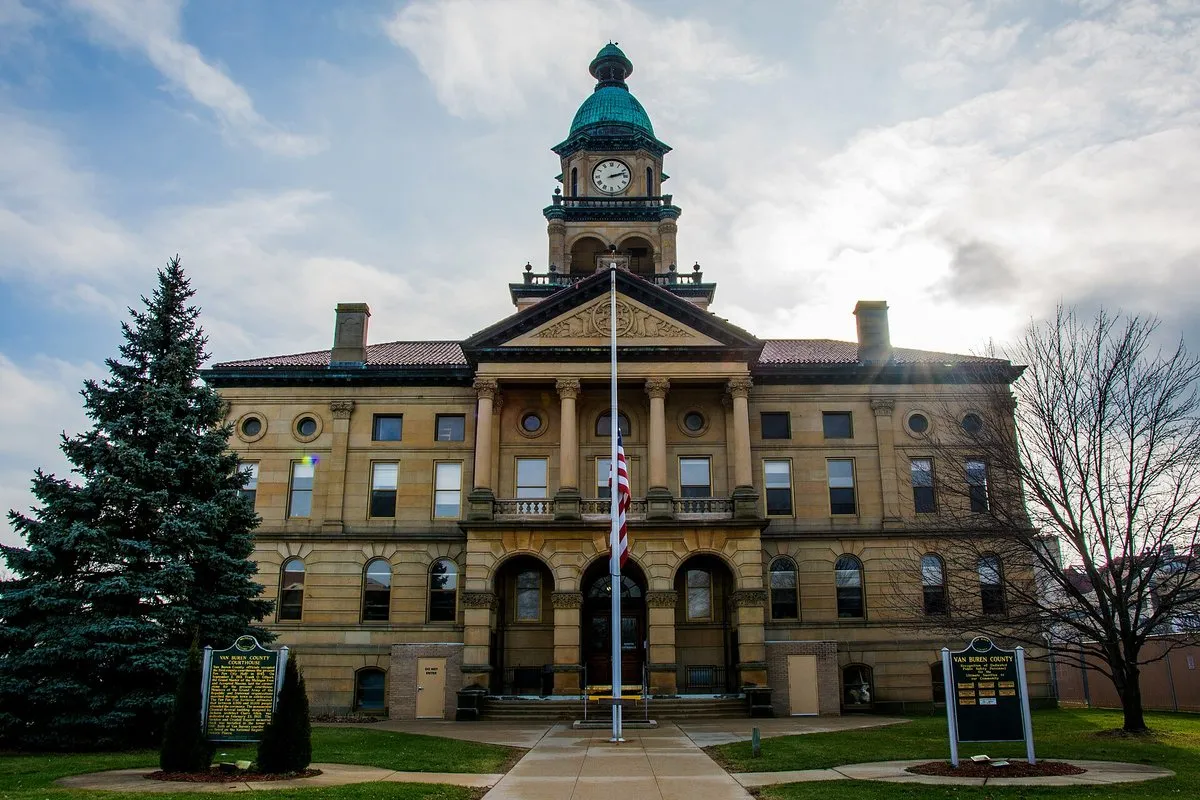
The courthouse you’ll see downtown is the county’s second. Van Buren County says its cornerstone was laid in 1901 in front of a crowd of 8,000 to 10,000, and the building was dedicated on February 23, 1903. Claire Allen of Jackson designed it in the Classical Revival style. The first courthouse wasn’t torn down: it was moved, and it’s now the Village Hall.
Paw Paw on the 1946 map
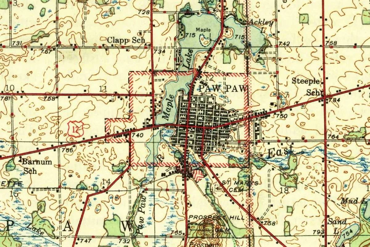
The map at the top of this page comes from the Geological Survey’s Marcellus quadrangle, a 1:62,500 sheet. The margin says it was “Mapped by the Geological Survey 1944,” and the title block names the Michigan State Highway Department. This copy is the “Edition of 1946,” with a road classification from that year and a Survey file stamp of November 12, 1946. The contour lines are drawn every 20 feet (6 m).
In this detail, the town sits as a black grid of streets inside a red hatched line at the south end of Maple Lake, with Ackley Lake off to the northeast. A blue line labeled “Paw Paw” runs through the lower left, and a stream marked “East” crosses on the right. Big spaced-out letters at the bottom spell part of the township’s name.
Quick answers
Is Paw Paw named after the fruit?
Indirectly. The 1880 county history says the village was called after the river, and the river was named “from the paw paw fruit, growing thickly upon its banks.”
Who named Paw Paw, Michigan?
Peter Gremps and Lyman J. Daniels, according to the 1880 history, which says they bought the sawmill in 1833 and laid out “a village which they called Paw Paw.”
What was Paw Paw Township called before?
Lafayette. The 1880 history says the township was renamed Paw Paw in 1867, after the village.
Key dates
- 1832Rodney Hinckley settles on the site, and Pierce Barber starts building a sawmill on the river, according to the 1880 county history.
- 1833Peter Gremps and Lyman J. Daniels buy the mill and lay out a village they call Paw Paw.
- 1835The township of Lafayette is formed on March 26; Gremps moves into a cabin by his sawmill.
- 1840A state act approved March 6 moves the Van Buren County seat to the village of Paw Paw.
- 1859The year the Village of Paw Paw gives for its establishment.
- 1867Lafayette Township is renamed Paw Paw, after the village, and the village is incorporated under an act of the Legislature, according to the 1880 history.
- 1903The current Van Buren County Courthouse is dedicated on February 23, two years after its cornerstone was laid.
- 1946The Geological Survey issues the 1946 edition of its Marcellus quadrangle, mapped in 1944.
Things to do in Paw Paw, Michigan
Van Buren County Courthouse
The county's Classical Revival courthouse, designed by Claire Allen of Jackson. Its cornerstone went down in 1901 before a crowd the county puts at 8,000 to 10,000, and it was dedicated on February 23, 1903.
Paw Paw Village Hall
The county's first courthouse. When the current one was built, the old building was moved, and it now serves as the Village Hall, according to the county.
Maple Lake
A village park on the lake north of downtown, with a playground, picnic tables, two pavilions and restrooms. The village describes it as a spot for fishing, swimming and picnicking.
Lake Front Park
A village park with an amphitheater, a boardwalk, two boat docks, picnic tables and grills.
Getting there
Open Paw Paw in Google Maps
Opens in a new tab. The pin is the center of Paw Paw in the USGS place-name record.
The closest airports, Amtrak stations and intercity bus stops, measured in a straight line from the center of Paw Paw.
Airports
- Kalamazoo/Battle Creek International (AZO) 17 mi 28 km
- South Bend International (SBN) 41 mi 67 km
- Chicago Midway International (MDW) 100 mi 161 km
Amtrak trains
- Bangor station (BAM) 13 mi 21 km
- Kalamazoo station (KAL) 17 mi 27 km
Intercity buses
- Greyhound Kalamazoo Bus Stop 17 mi 27 km
- Amtrak Chartered Vehicle Amtrak Connecting Service · Kalamazoo 17 mi 27 km
- Indian Trails Kalamazoo 17 mi 27 km
Distances are as the crow flies, not by road. We don't list schedules or fares because they change; check with the airline, Amtrak or the bus company before you go. Official data (FAA commercial service airports (2025), FAA airport locations, Amtrak stations and Intercity Bus Atlas) from the FAA and the U.S. Bureau of Transportation Statistics, checked Nov 18, 2026.
Sponsored
Staying in Paw Paw?
Compare hotels in Paw Paw, Michigan, on Expedia.
See hotels in Paw PawWe may earn a commission if you buy through this link. It never changes what we write. Read our affiliate disclosure
Historical Sources & References
- History of Berrien and Van Buren Counties, Michigan (D. W. Ensign & Co., 1880), pp. 360, 502, 506 and 509. The river named for the fruit, Lafayette renamed in 1867, the sawmill and Gremps and Daniels, the county-seat act of March 6, 1840, and the village’s incorporation in 1867. Checked against the page images.
- Henry Gannett, The Origin of Certain Place Names in the United States (1905), p. 240. “So named because of the presence of pawpaw trees.”
- Village of Paw Paw, “About”. “Established in 1859,” and the village named after the river, the river after the fruit.
- Van Buren County, “A Cornerstone at 125”. The cornerstone of 1901, the dedication of 1903, Claire Allen, and the first courthouse now used as the Village Hall.
- Village of Paw Paw, “Parks”. Maple Lake and Lake Front Park.
- Paw Paw’s GNIS entry, feature 634488 (U.S. Geological Survey). The village’s listing as a populated place in Van Buren County, with its coordinates.
- U.S. Geological Survey, Marcellus quadrangle (mapped 1944, edition of 1946). The 1:62,500 sheet the map at the top was cropped from.
Spot something wrong, or know more? Tell us here. You can also email us or use our contact page. Corrections are noted here with their date, never made silently.