Why Is It Called Port Aransas? Ropesville, Tarpon, Aransas
Port Aransas carries the name of Aransas Pass, the channel that splits Mustang Island from St. Joseph Island. The tourism office ties the name to jetty work on the pass; residents started using it around 1910, and the Handbook of Texas dates its adoption to April 1, 1911. The town had been Ropesville and then Tarpon.
Port Aransas, Texas, carries the name of Aransas Pass, the channel at its door, after spending its early decades as Ropesville and then as Tarpon. The town’s name is the easy part; where the word Aransas started is a question with three different answers.
Why is it called Port Aransas?
The town sits at the top end of Mustang Island, about 24 miles (39 km) northeast of Corpus Christi, right where Aransas Pass cuts through to the Gulf of Mexico. The Handbook of Texas describes the pass as “the water passage between Mustang and St. Joseph islands.” None of our sources states plainly that the pass gave the town its name, but the tourism office ties the name to the jetties built on the pass, as the next paragraph explains.
Hope played a part. For decades the government and private companies had tried to deepen the channel over the sandbar, and by 1919, the Handbook says, the new jetties had finally made it deepen. The Port Aransas tourism office says it was the fishing trade together with the hopes tied to those jetties that led residents to start calling their town Port Aransas. The city and the town museum both put that at “about 1910.”
The Handbook dates the official change to April 1, 1911. The tourism office comes at it from the post office’s side: the name had become so common, it says, that in 1911 the post office put it on its new building, and the town has kept it since.
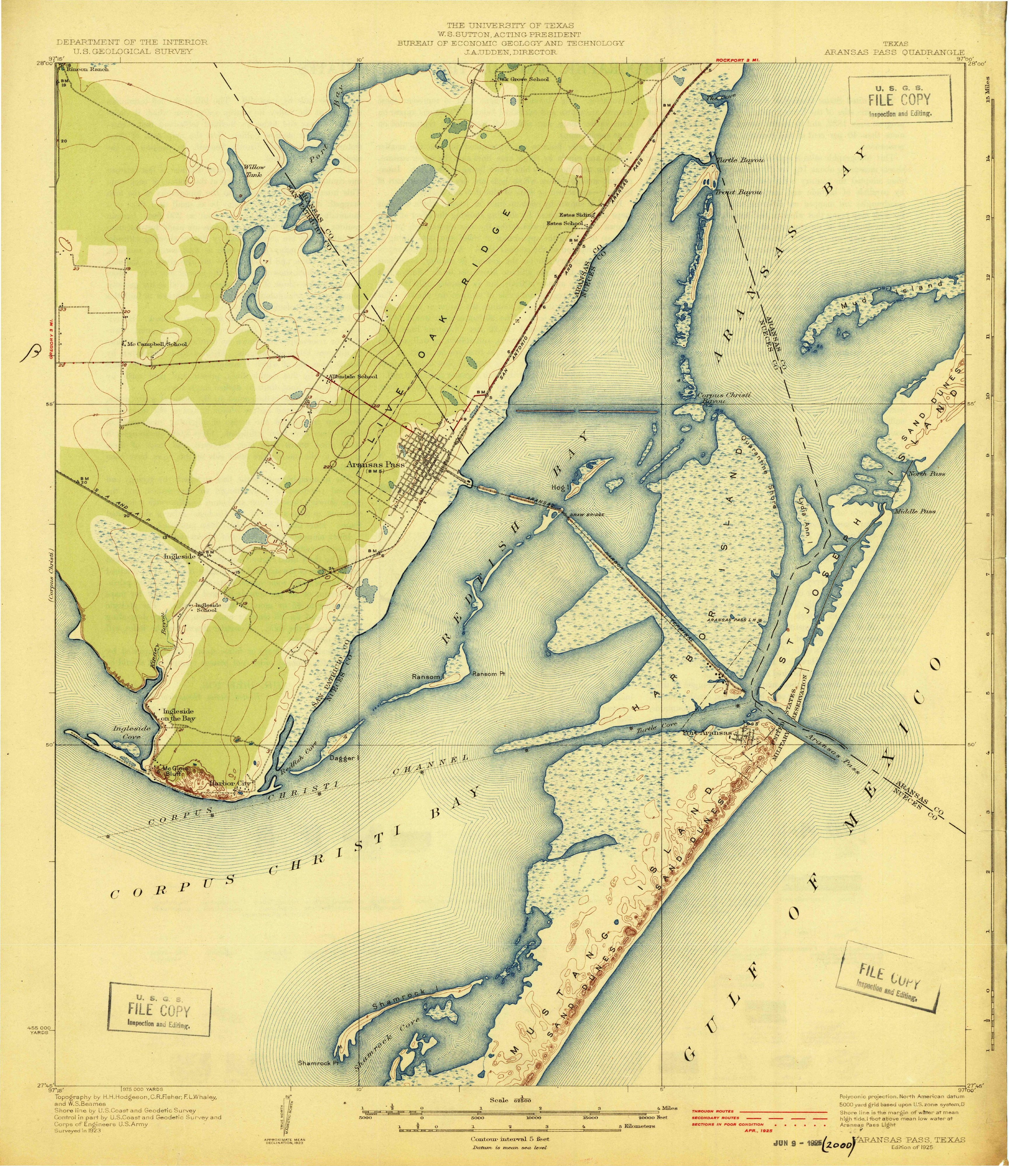
Don’t confuse it with the separate town of Aransas Pass, which the same 1925 map shows on the mainland.
What does Aransas mean?
The word came to the town secondhand, through the pass, and the pass got it from the Spanish. According to the Handbook, Prudencio de Orobio y Basterra, governor of the province, wrote it as Aránzazu on a map he drew in 1739, and by 1833 a map drawn by a Captain Monroe, master of the Amos Wright, had turned it into Aransas. A 1936 state highway marker for Aransas County puts it a slightly different way, saying the county was “Named for the River Nuestra Señora de Aranzazu.”
Past that point the sources don’t agree.
A palace in Spain
The Handbook’s entry on Aransas County says that late in the colonial period Spain put up a little fort at Live Oak Point and called it Aránzazu, “reportedly after a palace in Spain.” That word “reportedly” is the Handbook’s own hedge.
An American Indian group
The Handbook’s entry on the Aransas River, which empties into Copano Bay, says flatly that the river was “named for an American Indian group.” It doesn’t name the group.
The sanctuary of Arantzazu
The county history published by the Rockport-Fulton chamber traces the name to a Spanish outpost called “Rio Nuestra Señora de Aránzazu,” which it says was “named for the Sanctuary of Arantzazu, a Franciscan sanctuary in Oñati, Basque Country, Spain.” None of the Handbook entries we read makes that link, so we report it as the chamber’s account.
The town’s name points to the pass, and the pass goes back to Aránzazu on a 1739 map; what Aránzazu meant to whoever first used it here is not settled.
Port Aransas history: Sand Point, Ropesville and Tarpon
The place went through a string of names. The city says an 1833 map marked the site as Sand Point. The tourism office adds Mercer Docks, Star and plain Mustang to the list.
Mercer is the family name behind one of them. The Handbook says Robert A. Mercer, from Lancaster, England, started grazing sheep and cattle on neighboring St. Joseph Island in 1850 and put up a cabin on Mustang Island in 1855, and that William and Ed Mercer opened a store there in November 1880. Texas Parks and Wildlife, which opened a state park on the island in 1979, says a hurricane wiped out Mercer’s Dock in 1875 and a community called Mustang Island took its place. The island itself takes its name, the agency adds, from the mustangs, or wild horses, that roamed it.
Then came Elihu Harrison Ropes. The tourism office says he bought the whole island for $25,000, and the post office that opened in 1888 bore his name as Ropesville. In June 1890, says the Handbook, he began cutting a 30-foot (9 m) channel through the island so ships could reach Corpus Christi straight from deep Gulf water; it failed.
Tarpon followed. The Handbook says the name changed in 1896 “to celebrate the local fishing,” while the city puts it at “by 1899.” Either way it named the town after the fish anglers came for, and the museum says visitors traveled from all over the country to catch them in the early 1900s.
Growth was slow at first. The Handbook gives it 50 people in 1925 and 300 six years later, with the real growth coming as a resort after World War II.
Another Gulf town also went by the name of a pass first. A story told by a member of the Destin family says Destin, Florida, went by East Pass until a post office arrived, and that the postmaster named it for fisherman Leonard Destin. In Alabama, Gulf Shores says what brought people to its beaches was the Intracoastal Waterway, completed in 1937, and a state park that opened two years later.
Some 24 miles (39 km) to the southwest, Corpus Christi took its name from its bay, named in turn for a Catholic feast day. Farther down the Texas coast, South Padre Island remembers Padre José Nicolás Ballí, the Reynosa priest who first held a grant of land on it.
Port Aransas on the 1925 map
The image up top is cut from the Aransas Pass quadrangle, Texas, a 1:62,500 sheet that the Geological Survey produced together with the University of Texas Bureau of Economic Geology and Technology. It was surveyed in 1923 and printed as the “Edition of 1925,” with roads brought up to April 1925.
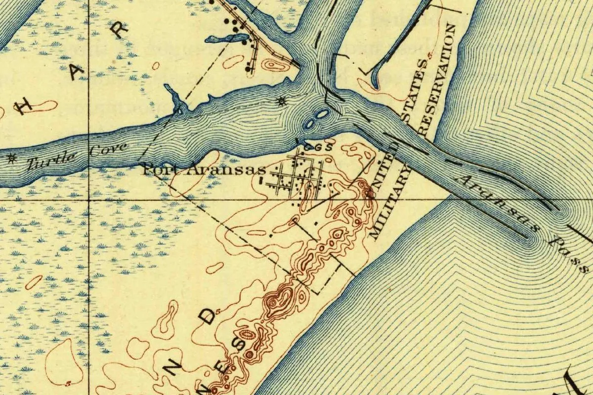
In the crop, “Port Aransas” is printed next to a cluster of short streets near the pass. Turtle Cove runs off to the west, the pass heads out to the Gulf between dashed jetty lines, and a strip along the beach is marked United States Military Reservation. Brown contour lines trace the sand dunes south of town.
Quick answers
How is Port Aransas pronounced?
The local tourism office writes Aransas as ə-RAN-zəs, which is part of why people shorten the town’s name to Port A.
What was Port Aransas called before?
Ropesville, for the post office opened in 1888, and then Tarpon. Earlier labels include Sand Point on an 1833 map and Mercer Docks, Star and Mustang.
When did Port Aransas get its name?
April 1, 1911, in the Handbook of Texas. Residents were already using the name about 1910, say the city and the museum.
Key dates
- 1739Orobio y Basterra, governor of the province, labels the pass Aránzazu on his map.
- 1833A map spells the pass Aransas, and a map of that year calls the spot where the town would grow Sand Point.
- 1855Robert A. Mercer moves from St. Joseph Island to a cabin he has built on Mustang.
- 1888A post office called Ropesville is established.
- 1890Elihu Harrison Ropes starts an unsuccessful channel across the island.
- 1896The town becomes Tarpon, says the Handbook of Texas.
- 1911On April 1, the name Port Aransas is adopted.
- 1925The Geological Survey's Aransas Pass quadrangle labels Port Aransas.
- 1979Mustang Island State Park opens on Mustang Island.
Things to do in Port Aransas, Texas
Port Aransas Museum
The town's history museum, run by the town's preservation and historical association. Among its permanent pieces are the Fresnel lens used in the Lydia Ann Lighthouse between 1878 and 1952, a bell off the locomotive that carried rock out for the jetties, and film footage of the town shot in the 1920s and 1930s.
Patton Center for Marine Science Education
The visitor center of UT Austin's Marine Science Institute: eight large aquariums, hands-on exhibits, talks by the keepers and feeding demonstrations about local marine life, beside the Wetlands Education Center trails.
Leonabelle Turnbull Birding Center
A city birding site with two boardwalks, 1,225 feet (373 m) long in all, over freshwater wetlands, plus shaded observation platforms and spotting scopes. From there a trail continues into the city's Charlie's Pasture preserve for another 1.25 miles (2 km) over salt marsh and prairie.
Mustang Island State Park
A state park on the island's Gulf beach. The state bought its 3,954 acres (1,600 ha) in 1972 and opened the park in 1979.
Getting there
Open Port Aransas in Google Maps
Opens in a new tab. The pin is the center of Port Aransas in the USGS place-name record.
The closest airports, Amtrak stations and intercity bus stops, measured in a straight line from the center of Port Aransas.
Airports
- Corpus Christi International (CRP) 27 mi 44 km
- Victoria Regional (VCT) 71 mi 114 km
- San Antonio International (SAT) 145 mi 234 km
Intercity buses
- Greyhound Aransas Pass Stripes 7 mi 12 km
Distances are as the crow flies, not by road. We don't list schedules or fares because they change; check with the airline, Amtrak or the bus company before you go. Official data (FAA commercial service airports (2025), FAA airport locations, Amtrak stations and Intercity Bus Atlas) from the FAA and the U.S. Bureau of Transportation Statistics, checked Nov 18, 2026.
Sponsored
Staying in Port Aransas?
Compare hotels in Port Aransas, Texas, on Expedia.
See hotels in Port AransasWe may earn a commission if you buy through this link. It never changes what we write. Read our affiliate disclosure
Historical Sources & References
- Handbook of Texas, “Port Aransas, TX”. Mercer, Ropes, Ropesville in 1888, Tarpon in 1896 and the April 1, 1911, change.
- Handbook of Texas, “Aransas Pass”, “Aransas County” and “Aransas River”. Orobio y Basterra’s 1739 map, the 1833 spelling, the jetties, the fort “reportedly after a palace in Spain” and the river “named for an American Indian group.”
- City of Port Aransas, “Our History” and Port Aransas Museum, “History of the Island”. Sand Point, Ropesville, Tarpon and “about 1910.”
- Port Aransas tourism office, “How Do You Say Port Aransas?”. The pronunciation, the other early names and the 1911 post office.
- Rockport-Fulton chamber, “History of Aransas County” and the 1936 Aransas County marker. The sanctuary of Arantzazu and the River Nuestra Señora de Aranzazu.
- Texas Parks and Wildlife Department, Mustang Island State Park history. Mercer’s Dock, the island’s wild horses and the park’s dates.
- U.S. Geological Survey, GNIS feature 1344363. Port Aransas in Nueces County.
- Aransas Pass quadrangle, Texas, 1925. The sheet the map at the top was cropped from.
Sponsored
Put this 1925 map on your wall
The Geological Survey's 1925 Aransas Pass sheet, surveyed in 1923 with the University of Texas, with Port Aransas at the tip of Mustang Island, is in the public domain. Download the full-size scan for free, then have it printed on canvas with CanvasOnTheCheap.
Print a map on canvasDownload the full-size mapWe may earn a commission if you buy through this link. It never changes what we write. Read our affiliate disclosure
Spot something wrong, or know more? Tell us here. You can also email us or use our contact page. Corrections are noted here with their date, never made silently.