Who Is South Padre Island Named After? Padre Ballí
South Padre Island is the southern tip of Padre Island, which is named for Padre José Nicolás Ballí, a Catholic priest from Reynosa. He and his nephew held the island's earliest known grant of land and ran cattle there in the early 1800s. Earlier maps and papers called it Isla Blanca, Isla de Corpus Christi and other names.
South Padre Island is named for Padre José Nicolás Ballí, a Reynosa priest who held the island’s earliest known grant of land and ran cattle on it. The town occupies the southern tip of Padre Island, the island that carries his name.
Who is South Padre Island named after?
Padre Ballí. Clotilde P. García’s Handbook of Texas biography calls him an original grantee “of the Texas coastal island later named Padre Island in his honor.” A 2023 resolution of the Texas House, written for the town’s 50th anniversary, says the island “was named after Padre José Nicolás Ballí, who was awarded the island’s first known land grant.”
He was born in Reynosa, on the Rio Grande, into a family with a lot of land. Sources differ on the details. García puts his birth around 1770 and says he trained at the seminary in Monterrey; the National Park Service, whose Padre Island National Seashore covers a long stretch farther up the island, says around 1768 and has him studying at the University of Salamanca, in Spain. Both say he was ordained around 1790 or 1791. García adds that he was a priest at the Refugio mission in Matamoros from 1804 to 1829 and that from 1800 on he officiated at over 500 baptisms, weddings and funerals.
She sums up his career as that of “a missionary, a rancher, a colonist, and an explorer.” The ranching side of his life is the one that tied him to a Gulf of Mexico barrier island.
A land grant with a lot of dates
If you want one date for the grant, you won’t get it. Here’s what each source says.
- 1759: García writes that King Carlos III of Spain granted the island to the priest’s grandfather, also named Nicolás Ballí, and that the padre asked for clear title in 1827.
- 1800 to 1805: The Park Service says he asked the Spanish crown for the grant at some point in those years.
- 1804: The Park Service dates his ranch, Santa Cruz de Buena Vista, to around 1804.
- 1805: Art Leatherwood’s Handbook entry on Padre Island says the first known grant “is believed to have been given” to Ballí and his nephew that year.
- 1829: Leatherwood says the Mexican state of Tamaulipas perfected the grant on February 21. García gives April 16, 1829, as the day of his death and says the title came through afterward, on December 15, issued to him and to Juan José Ballí, his nephew.
The ranch sat about 26 miles (42 km) up the island from its southern end, according to García and the Park Service, or “some twenty-four miles” (39 km), according to Leatherwood. His will of 1811 listed 1,000 head of cattle, the Park Service says. Did the padre live there? The Park Service says he never did and that two hired hands made their home there, and Steve Hathcock, writing in the Port Isabel-South Padre Press in 2017, says the nephew ran things day to day. García tells it differently: she calls Ballí “the first settler on the island who brought in families” and says he built its first church.
What was Padre Island called before?
Plenty of things. The Park Service says that before Ballí applied, the island had been known as “Isla Blanca” or “La Isla de los Malaquittas,” and that it became the “Isla de Corpus Christi” after Corpus Christi Bay was named in 1766. That’s the same bay that gave Corpus Christi its name, at the island’s north end. García calls Ballí’s holding “the Isla de Santiago grant, known as Padre Island.” Hathcock’s list adds Amichel, La Florida, Isla Malhado, Isla de Boyan and Ysla del Vallin.
When did people start saying Padre Island? Hathcock found the oldest printed use in a London paper of April 24, 1841, which reported that three Texans “were killed on Padres Island.” By 1844, he wrote, the island was “almost exclusively referred to as Padre Island.” We haven’t seen that 1841 paper ourselves, so take the date as his finding.
The island stayed Mexican for a while even after Texas broke away in 1836. Leatherwood says Mexico held on to it through 1848, when the Treaty of Guadalupe Hidalgo was signed. In a different history, the Park Service says that after the same treaty, settlers who preferred to stay on Mexican soil crossed to the Rio Grande’s west bank and founded Mesilla, New Mexico.
South Padre Island history: from ferry to town
For a long time you couldn’t drive there. Alicia A. Garza writes in the Handbook that the only way over from the late 1800s into the 1950s was by ferry. A swing bridge from Port Isabel, costing $2.2 million, opened in February 1954, and Garza says the area wasn’t developed until after that. Hurricane Beulah then destroyed much of Port Isabel and of the young town in 1967.
Then came the town itself. The House resolution says the bridge “ushered in a new era of development,” and that a campaign to incorporate “succeeded with a majority vote on April 10, 1973.” Hathcock gives the count from the election returns: 158 votes cast, 128 for and 28 against, with two ballots thrown out as illegible. Leatherwood records the incorporation in 1973 too.
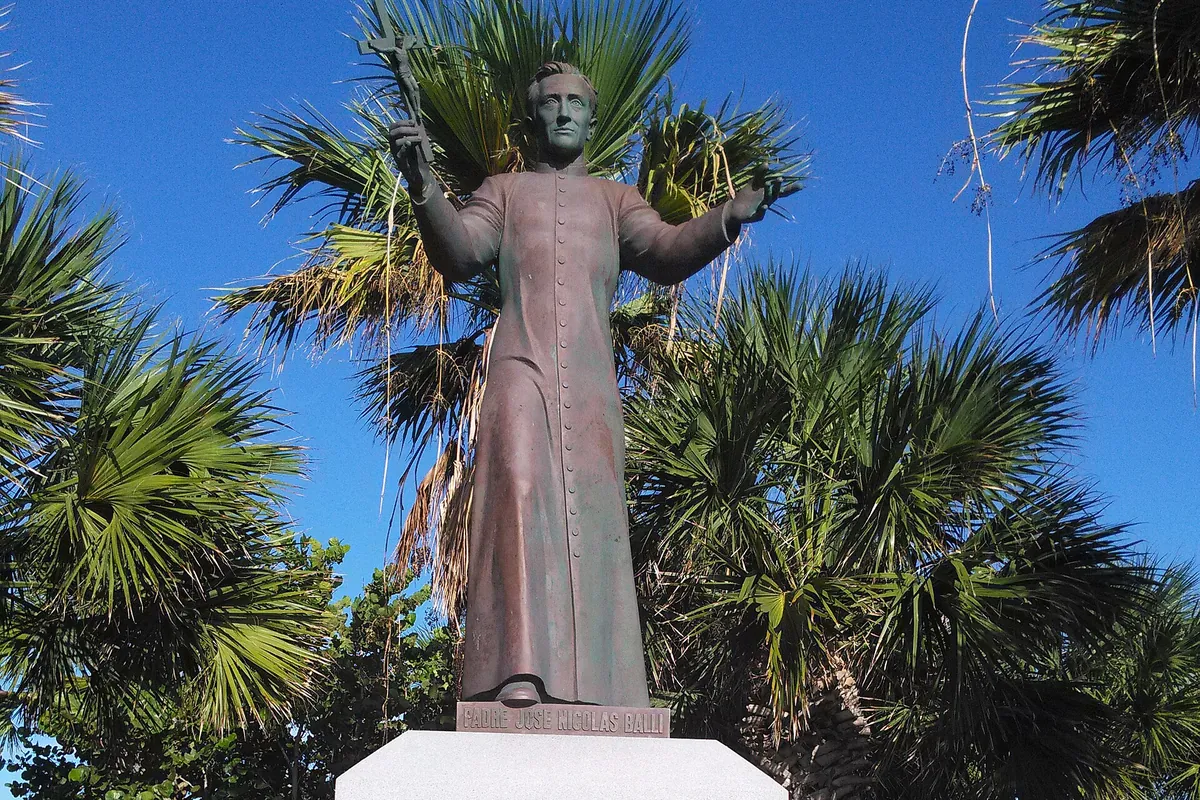
Today a statue of Ballí, arms open, stands where the Queen Isabella Memorial Causeway lands on the island, Hathcock says, greeting you as you come over. Far to the north, De Smet, South Dakota, also carries a missionary priest’s name: Father Pierre-Jean De Smet, a Jesuit from Belgium who worked with the Sioux.
The Ballí name turns up elsewhere in the Rio Grande Valley, in the story of McAllen, through Salomé Ballí, who inherited the Santa Anita Ranch. The sources we used don’t connect her to the padre, so we won’t either.
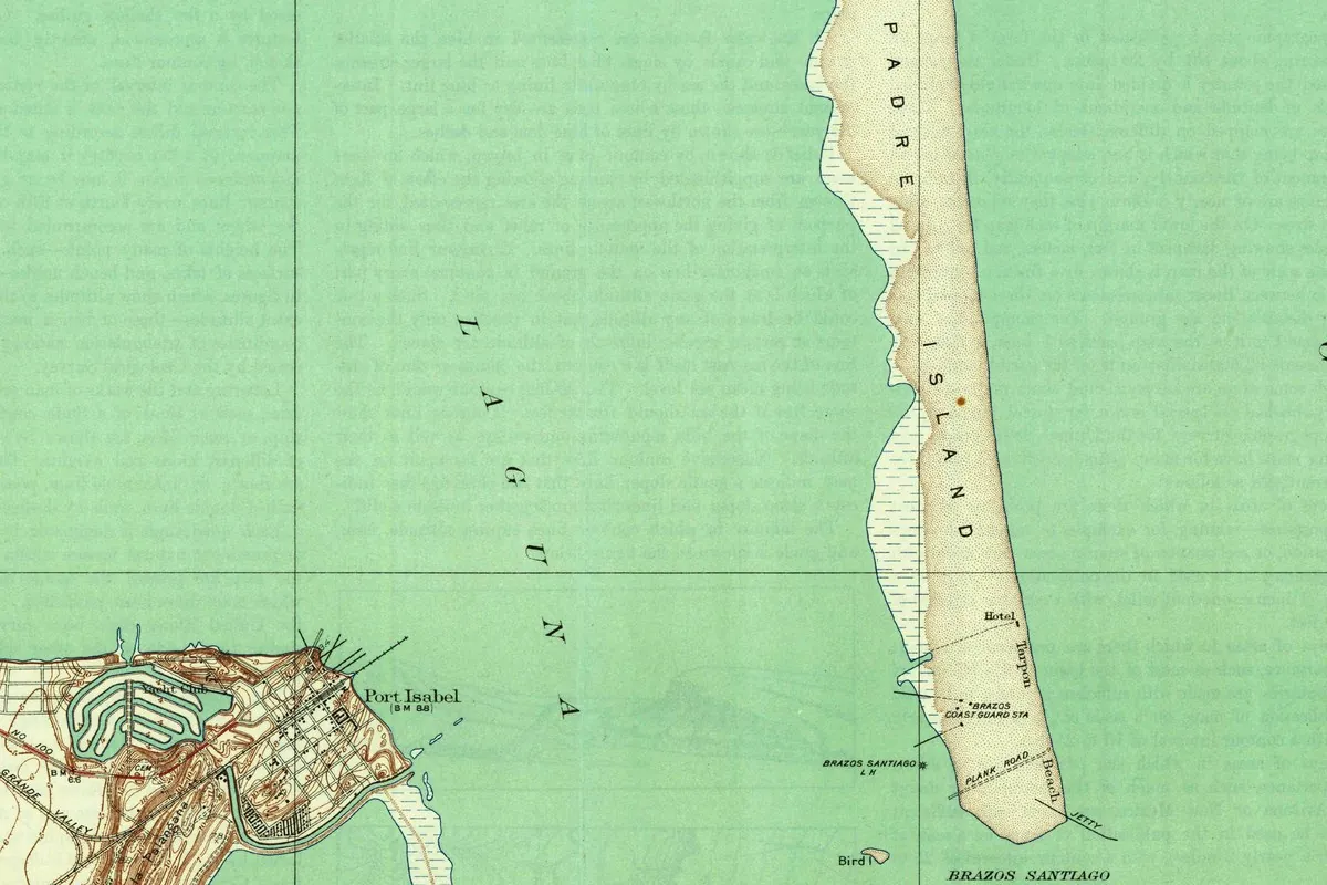
South Padre Island on the 1934 map
The town didn’t exist when this map was made, so you won’t find it on the sheet. What you’ll find is the southern end of Padre Island as it looked before the town, with a few scattered buildings.
The map is the Port Isabel quadrangle, at 1:31,680. The top margin names the U.S. Geological Survey alongside Cameron County, Texas, with A. W. Cunningham as county judge and W. O. Washington as county engineer. The bottom margin credits topography to R. H. Reineck and J. B. Leachman, says the culture and drainage of Padre and Brazos islands were compiled from aerial photographs with contours not mapped, and gives “Surveyed in 1929.” A red line adds “Information furnished by Cameron County, 1932,” and the corner reads “Edition of 1934.”
On the full sheet, Padre Island comes in from the top, right of center, and ends at the gap labeled Brazos Santiago, with Brazos Island below it. In the crop, the island’s tip carries a Hotel, Tarpon Beach, the Brazos Coast Guard station, a plank road and a jetty. Across the Laguna Madre you can see Port Isabel’s street grid and its yacht club. Faint lines of text show through the paper in places.
Quick answers
Who is South Padre Island named after?
Padre José Nicolás Ballí, a priest from Reynosa who held Padre Island’s earliest known grant of land, according to García’s Handbook entry and a 2023 Texas House resolution. The town is named after the island, whose southern tip it occupies.
Did Padre Ballí live on Padre Island?
The sources split. The Park Service says he never lived there and that two hired hands ran the ranch, and Steve Hathcock says his nephew handled the daily work. García’s Handbook entry calls him the island’s first settler who brought in families.
What was Padre Island called before?
Isla Blanca and La Isla de los Malaquittas, then the Isla de Corpus Christi after 1766, by the Park Service’s account. The Handbook calls Ballí’s grant the Isla de Santiago.
When did South Padre Island become a town?
Residents voted to incorporate on April 10, 1973, according to the Texas House resolution.
Key dates
- 1759Spain's King Carlos III grants the island to Nicolás Ballí, the priest's grandfather, according to the Handbook of Texas.
- 1766Corpus Christi Bay gets its name, and the island becomes the Isla de Corpus Christi, by the Park Service's account.
- 1804Padre Ballí sets up the Santa Cruz de Buena Vista ranch, around this year in the Park Service's telling.
- 1811Ballí's will lists 1,000 head of cattle.
- 1829Ballí dies on April 16; the title to the island is issued in his name and his nephew's on December 15.
- 1841A London paper reports Texans killed on "Padres Island," the oldest printed use of the name that Steve Hathcock found.
- 1848The Treaty of Guadalupe Hidalgo ends Mexico's hold on the island, according to the Handbook.
- 1934The Geological Survey and Cameron County publish the Port Isabel quadrangle.
- 1954A swing bridge from Port Isabel to the island opens in February.
- 1973Island residents vote to incorporate on April 10.
Things to do in South Padre Island, Texas
Sea Turtle, Inc.
A rescue and rehabilitation center for sea turtles where you walk through the hospital and education buildings on your own, meet the patients and the turtles that can't go back to the Gulf, and catch the regular talks.
South Padre Island Birding, Nature Center & Alligator Sanctuary
Over 3,300 feet (1,006 m) of boardwalk over tidal wetlands on the Laguna Madre, five bird blinds, a five-story tower for the view, and an alligator sanctuary with rescued gators. It's the island's World Birding Center site.
Laguna Madre Nature Trail
A boardwalk that runs from the convention center's parking lot out to the Laguna Madre, through a marsh that shifts from fresh water to salt. Texas Parks and Wildlife rates it an excellent spot for seeing rails.
Causeway tidal flats walkway
A paved path the city built across the mangroves and tidal flats on both sides of the Queen Isabella Causeway, where shorebirds, gulls and terns rest. The statue of Padre Ballí stands at the island end of the causeway.
Port Isabel Lighthouse (in Port Isabel)
Across the causeway in Port Isabel, a 72-foot (22 m) lighthouse built in 1852 after many wrecks off Brazos Island. It went dark in 1905 and got a Fresnel lens again in 2022. You can climb to the top, and a rebuilt keeper's cottage serves as a museum.
Getting there
Open South Padre Island in Google Maps
Opens in a new tab. The pin is the center of South Padre Island in the USGS place-name record.
The closest airports, Amtrak stations and intercity bus stops, measured in a straight line from the center of South Padre Island.
Airports
- Brownsville/South Padre Island International (BRO) 21 mi 34 km
- Valley International (HRL) Harlingen 32 mi 51 km
Intercity buses
- Greyhound Brownsville Bus Station 25 mi 40 km
Distances are as the crow flies, not by road. We don't list schedules or fares because they change; check with the airline, Amtrak or the bus company before you go. Official data (FAA commercial service airports (2025), FAA airport locations, Amtrak stations and Intercity Bus Atlas) from the FAA and the U.S. Bureau of Transportation Statistics, checked Nov 18, 2026.
Sponsored
Staying in South Padre Island?
Compare hotels in South Padre Island, Texas, on Expedia.
See hotels in South Padre IslandWe may earn a commission if you buy through this link. It never changes what we write. Read our affiliate disclosure
Historical Sources & References
- Clotilde P. García, “Ballí, José Nicolás,” Handbook of Texas Online. Birth around 1770 in Reynosa, the Monterrey seminary, the Refugio mission, the 1759 grant to his grandfather, the 1827 request, the ranch 26 miles (42 km) from the tip, his death on April 16, 1829, and the title of December 15, 1829.
- Art Leatherwood, “Padre Island,” Handbook of Texas Online. The grant “believed” given in 1805, the ranch “some twenty-four miles” (39 km) from the south end, February 21, 1829, the Treaty of Guadalupe Hidalgo and incorporation in 1973.
- Alicia A. Garza, “South Padre Island, TX,” Handbook of Texas Online. The ferry era, the swing bridge of February 1954 and Hurricane Beulah in 1967.
- National Park Service, “Padre Balli”. The ranch around 1804, birth around 1768, Salamanca, the application of 1800-05, Isla Blanca, Malaquittas and Isla de Corpus Christi, the 1811 will and the hired hands.
- Texas House, H.R. No. 1835 (2023). “Named after Padre José Nicolás Ballí” and the vote of April 10, 1973.
- Steve Hathcock, “How did Padre Island get its name?” Port Isabel-South Padre Press (2017). Earlier names, the London paper of 1841, “by 1844,” the vote count and the statue.
- Sea Turtle, Inc., SPI Birding, Nature Center & Alligator Sanctuary, Texas Parks and Wildlife, South Padre Island Loop and Texas Historical Commission, Port Isabel Lighthouse. The details in the things-to-do list.
- U.S. Geological Survey, GNIS feature 1376223. South Padre Island in Cameron County.
- Port Isabel quadrangle, surveyed 1929, 1934 edition. The sheet the map at the top was cropped from.
Spot something wrong, or know more? Tell us here. You can also email us or use our contact page. Corrections are noted here with their date, never made silently.