Shiner, Texas: Named for the Rancher Who Gave the Land
Shiner is named for Henry B. Shiner, a Victoria landowner who gave land to the San Antonio and Aransas Pass Railway when it came through in 1887. The town that grew around the depot was first called New Half Moon, with the older Half Moon nearby, and became Shiner in 1888, the Handbook of Texas says.
Shiner, Texas, is named for Henry B. Shiner, who gave the railroad land in 1887. For a short while, the town that grew there was called New Half Moon. The old Half Moon never got the trains, and the name it lent the new town didn’t last long.
Half Moon
Before Shiner, there was Half Moon, on Rocky Creek. A state historical marker put up in 2011 traces the place back to 1689, when Alonso de León’s expedition met a Native American people who called Half Moon home. It says “the area was known as Half Moon due to the peculiar shape of the timber in the area.”
Settlers came to trade and farm from the 1830s, in the marker’s account, and Half Moon had its best years from 1885 to 1887, with stores, a saloon and a post office. Mary Ramsey’s entry in the Handbook of Texas says the Half Moon post office opened in 1885 “at a trading post near the present site of Shiner.” A 1969 marker calls it a “German-Czech community … located west of present town.”
The rancher and the railroad
Then came the railroad, and it didn’t go through Half Moon. Ramsey writes that when the San Antonio and Aransas Pass Railway reached the area in 1887, it “bypassed Half Moon and built through land owned by Henry B. Shiner. Shiner donated 250 acres for a right-of-way and depot, and a town soon grew around the new transportation facilities.” That’s about 101 hectares.
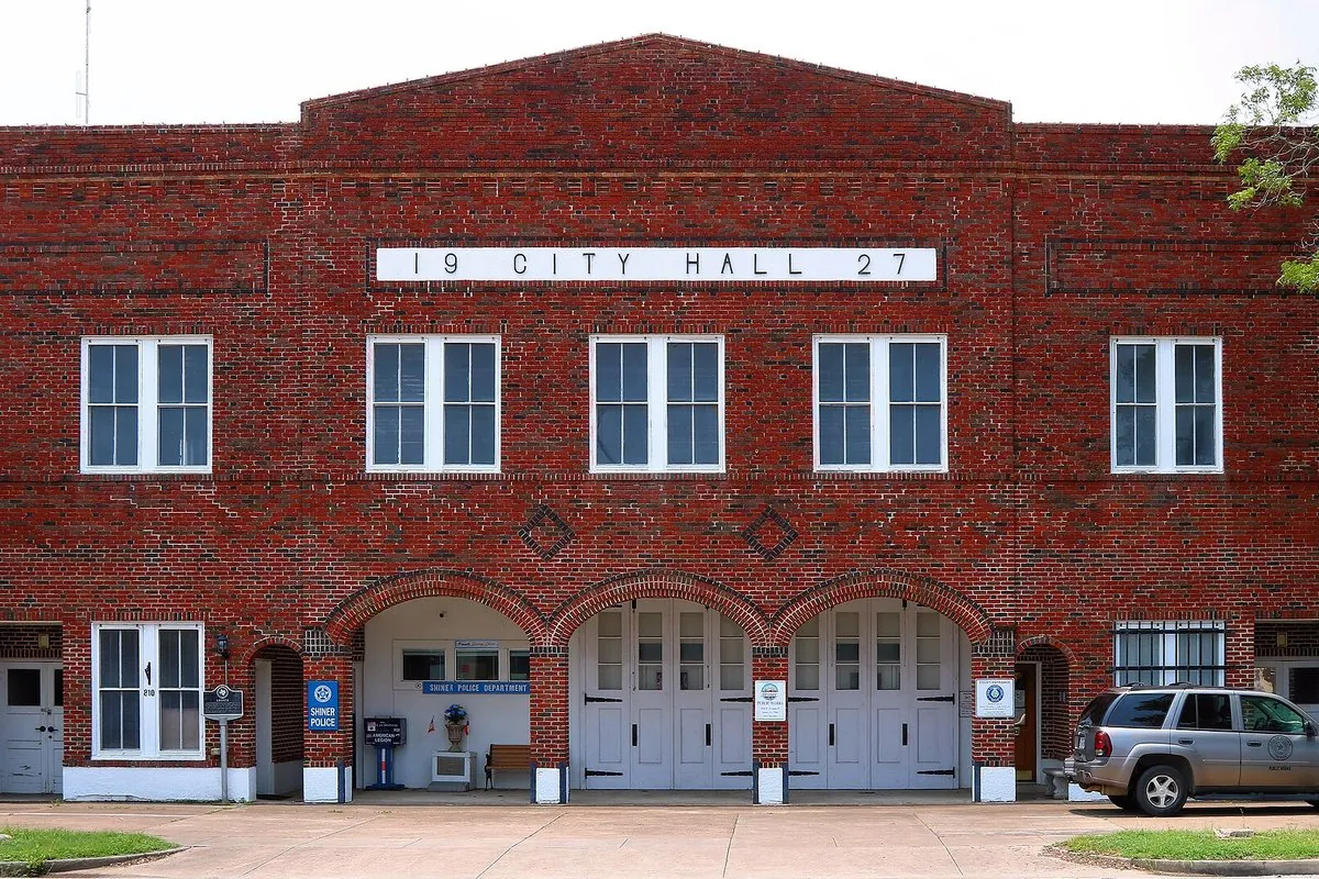
The 1969 marker, which you’ll find on the City Hall grounds, tells it from the townspeople’s side: “citizens moved to rail line, where H. B. Shiner, Victoria landowner, had given a townsite.” Another marker, at the old Shiner-Welhausen homestead, says Henry B. Shiner had bought that land in 1875 “for his cattle raising enterprise,” and that in 1887 “he donated land for a townsite, which was later named in his honor.”
Other railroad towns got their land in other ways. Elsewhere in Texas, in Hearne, a widow deeded 700 acres (283 ha) to keep her late husband’s promise. In Durham, North Carolina, a doctor gave the depot land after William Pratt refused, and in Dillon, Montana, a rancher who wouldn’t give up a right-of-way held the line up until local merchants bought him out.
From New Half Moon to Shiner
The new town didn’t take Shiner’s name right away. “At first the community was called New Half Moon,” the Handbook says, “but in 1888 its name was changed to Shiner.” The Half Moon marker agrees that “for a short while, the area was known as New Half Moon.” Neither source says who made the change.
Shiner was incorporated in 1890, with L. P. Amsler as its first mayor. Ramsey writes that Czech and German immigrants soon became the main groups in town. The Shiner-Welhausen marker adds that the Shiner family kept living on the homestead until 1890, even though they’d sold it to Charles Welhausen in 1884.
The brewery came two decades later. Diana J. Kleiner’s Handbook entry on the Spoetzl Brewery says a group of Shiner businessmen founded the Shiner Brewing Association in 1909, with Herman Weiss of Galveston as the first brewmaster. So the beer carries the rancher’s name too.
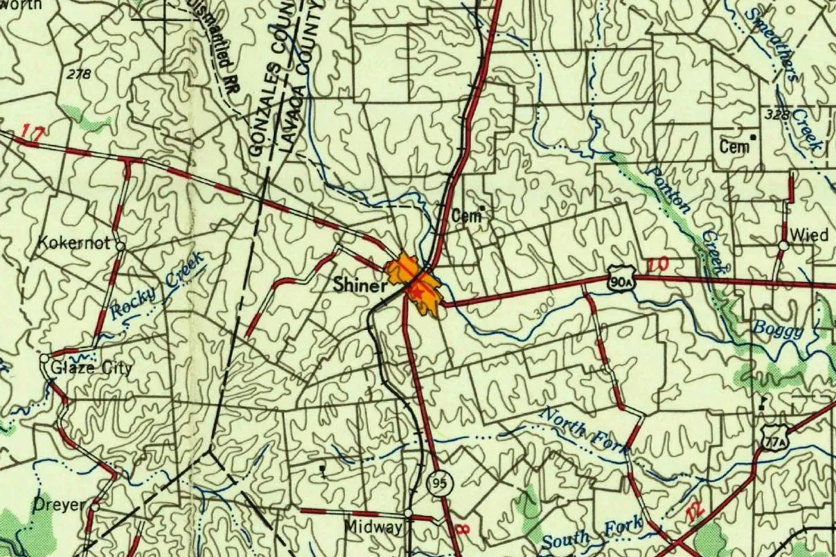
Shiner on the 1958 map
The map at the top of this page is the Seguin sheet, NH 14-9, at 1:250,000. Its margin says it was “Prepared by the Army Map Service … Corps of Engineers, U. S. Army” and “Compiled in 1954 by photogrammetric methods,” from aerial photography of 1952-1953, and that it was for sale by the U.S. Geological Survey. The printer’s line reads “PRINTED BY ARMY MAP SERVICE, CORPS OF ENGINEERS, 1-58,” so this copy came off the press in January 1958; the Survey’s file copy is stamped February 4, 1958, with a handwritten note that it was printed for the Survey.
In this detail, you can see Shiner as an orange patch where routes 90A and 95 cross, the junction the Handbook describes, fourteen miles (23 km) west of Hallettsville. Rocky Creek, Half Moon’s stream, is close by, and so are Kokernot, Glaze City, Dreyer, Midway and Wied. A railroad line runs through town, part of a label reading “Dismantled RR” sits at the top, and the line between Gonzales County and Lavaca County runs past to the west. The contour lines are drawn every 50 feet (15 m).
Quick answers
Who is Shiner, Texas, named after?
Henry B. Shiner, a Victoria landowner and cattleman who gave land to the San Antonio and Aransas Pass Railway in 1887.
What was Shiner called before?
New Half Moon, for a short while. The older Half Moon, west of town, had a post office from 1885.
When did Shiner get its name?
In 1888, according to the Handbook of Texas. The town was incorporated two years later.
Key dates
- 1689Alonso de León's expedition meets a Native American people who called Half Moon home, by the Half Moon marker's account.
- 1875Henry B. Shiner buys the land for his cattle ranch.
- 1885A post office called Half Moon opens at a trading post near the present town.
- 1887The San Antonio and Aransas Pass Railway bypasses Half Moon and builds through Shiner's land; he gives 250 acres (101 ha) for a right-of-way and depot.
- 1888The new town's name is changed from New Half Moon to Shiner.
- 1890Shiner is incorporated, with L. P. Amsler as its first mayor.
- 1909Local businessmen found the Shiner Brewing Association.
Things to do in Shiner, Texas
Edwin Wolters Memorial Museum
Shiner's local museum, where antique guns and an old-time country store share space with dinosaur bones, needlework, dolls, instruments and a shed of farm implements.
Spoetzl Brewery tour
An interactive tour of the K. Spoetzl Brewery that takes you through how Shiner's beers are made, from start to finish. You must be 21 to visit.
Green-Dickson Municipal Park
A 148-acre (60 ha) city park with playgrounds, covered picnic areas, lighted courts, fishing spots and a baseball and softball complex.
Shiner historical marker
The 1969 state marker on the City Hall grounds that tells how the people of Half Moon moved to the rail line, where H. B. Shiner had given a townsite.
Getting there
Open Shiner in Google Maps
Opens in a new tab. The pin is the center of Shiner in the USGS place-name record.
The closest airports, Amtrak stations and intercity bus stops, measured in a straight line from the center of Shiner.
Airports
- Victoria Regional (VCT) 43 mi 68 km
- Austin-Bergstrom International (AUS) 61 mi 98 km
Amtrak trains
- San Marcos station (SMC) 56 mi 90 km
- Austin station (AUS) 68 mi 109 km
Intercity buses
- FlixBus San Marcos CARTS 56 mi 90 km
Distances are as the crow flies, not by road. We don't list schedules or fares because they change; check with the airline, Amtrak or the bus company before you go. Official data (FAA commercial service airports (2025), FAA airport locations, Amtrak stations and Intercity Bus Atlas) from the FAA and the U.S. Bureau of Transportation Statistics, checked Nov 18, 2026.
Sponsored
Staying in Shiner?
Compare hotels in Shiner, Texas, on Expedia.
See hotels in ShinerWe may earn a commission if you buy through this link. It never changes what we write. Read our affiliate disclosure
Historical Sources & References
- Mary Ramsey, “Shiner, TX,” Handbook of Texas Online. The Half Moon post office of 1885, the railroad of 1887, the 250 acres, New Half Moon, the change of 1888 and incorporation in 1890.
- Texas Historical Commission, “Shiner” marker (1969). Half Moon “west of present town” and the townsite given by H. B. Shiner.
- Texas Historical Commission, “Shiner-Welhausen Homestead” marker (1989). Shiner’s purchase of 1875 and the townsite “later named in his honor.”
- Texas Historical Commission, “Half Moon” marker (2011). The 1689 expedition, the shape of the timber, and New Half Moon.
- Diana J. Kleiner, “Spoetzl Brewery,” Handbook of Texas Online. The Shiner Brewing Association of 1909.
- Edwin Wolters Memorial Museum, Green-Dickson Municipal Park and Spoetzl Brewery tours. The places listed above.
- Shiner’s GNIS entry, feature 1347067 (U.S. Geological Survey). The city’s listing as a populated place in Lavaca County, with its coordinates.
- Army Map Service, Seguin sheet NH 14-9 (compiled 1954, printed January 1958). The 1:250,000 sheet the map at the top was cropped from.
Spot something wrong, or know more? Tell us here. You can also email us or use our contact page. Corrections are noted here with their date, never made silently.