What Does Paso Robles Mean? The Pass of the Oaks
Paso Robles is short for El Paso de Robles, Spanish for the pass of the oaks, and a 2020 city council resolution still uses the long name. Nellie Van de Grift Sanchez wrote in 1914 that the name follows Father Crespi's description of a valley called Los Robles for its many oak trees.
Paso Robles, California, is short for El Paso de Robles, Spanish for the pass of the oaks, and the city government still uses the long name. A 2020 council resolution, No. 20-117, is titled as a resolution “of the City Council of the City of El Paso de Robles,” even though its own text, like the city’s history page, says Paso Robles. So if you’ve wondered what the name means, the full version tells you: a pass, and the oaks around it.
The pass of the oaks
Henry Gannett’s 1902 book on name origins, published by the Geological Survey, kept it short: “Paso Robles; city in San Luis Obispo County, California. A Spanish word, meaning ‘pass of the oak trees.’” Strictly it’s two Spanish words, but the meaning holds.
Nellie Van de Grift Sanchez went further in 1914, in her book on the Spanish and Indian place names of California. She gave the name as Paso de Robles, “pass of the oaks,” and put the town “twenty-nine miles north of San Luis Obispo,” about 47 km. Then she traced it to the Spanish expeditions:
“It was named for the reason indicated by Father Crespi, who says: ’ . . . . in a valley in the hollow of the Santa Lucía Mountains, called Los Robles, for the great abundance of these trees with which it is populated.’”
Sanchez doesn’t give the date of Crespi’s entry, so this page won’t either. What the quote gives you is the reason: a valley so full of oaks that the Spaniards just called it the Oaks.
San Luis Obispo, those 29 miles to the south, carries the name of a Franciscan bishop. Paso Robles carries a description of the land.
Not just any oak
Here’s the detail that’s easy to miss. Spanish has more than one word for oak, and Sanchez was careful about it. “It should be explained,” she wrote, “that the roble is not the evergreen, or live-oak, which is called encino.” She even pointed out that Stanford University had named two dormitories after the pair, Encina Hall for the men and Roble Hall for the women.
That puts Paso Robles in a different grove from some of its neighbors on the map of California. Encinitas, down in San Diego County, is named for little encinos, and its article quotes the same line from Sanchez. Oakland grew up in an oak grove that the Peralta rancho called the Encinal de Temescal. Paso Robles is the robles, not the encinos.
A rancho and its springs
Before there was a town, the pass was part of a land grant. The City of Paso Robles says the Paso Robles Rancho, also known as the Paso de Robles Land Grant, was granted to Pedro Narvaez, who left it to Petronilo Rios. In 1857 the whole rancho was bought by James H. Blackburn, Daniel Drew Blackburn and Lazarus Godchaux for $8,000. In 1860 the partners divided it, and Daniel Blackburn took the hot springs and a league of land around them.
The springs were the draw. The city says Salinan people lived on the land long before the mission era, and that as far back as 1795 Paso Robles was spoken of as “California’s oldest watering place.” Sanchez, for her part, called it “known far and wide for its hot sulphur springs.”
One of the later owners had a famous nephew. In 1865, the city says, Daniel Blackburn sold a half-interest in the springs to a Mr. McCreel, who sold out to Drury James, brother-in-law of D. D. Blackburn and uncle of the outlaw Jesse James. By the time the railroad arrived in the late 1880s, Drury James and the Blackburn brothers put out a pamphlet with a title that used the full name: “El Paso de Robles Hot and Cold Sulphur Springs and the Only Natural Mud Baths in the World.”
You’ll find the Spanish word for hot in Caliente, Nevada, which was named for its hot springs. In Paso Robles, the springs made the business, but the oaks kept the name.
A town in 1886
The town itself came with the train. According to the city, the first train arrived on October 31, 1886. Two weeks later there was a three-day celebration for land buyers who came down from San Francisco, and on November 17, 1886, the “Grand Auction” sold 228 lots. A year later the city counted 523 residents and 100 buildings.
Paso Robles was incorporated in 1889. City Park went in around then, on land the founders donated for a public park, and in 1891 the three-story Hotel El Paso de Robles opened along with a bathhouse over the sulfur spring. The city says the hotel is known today as the Paso Robles Inn.
The “pass” part has company too. Over in El Paso, Texas, the name is “the pass” of the Rio Grande, the old crossing known as El Paso del Norte. Paso Robles never had a famous river crossing in its name; it had a valley full of oaks.
Paso Robles on the 1919 map
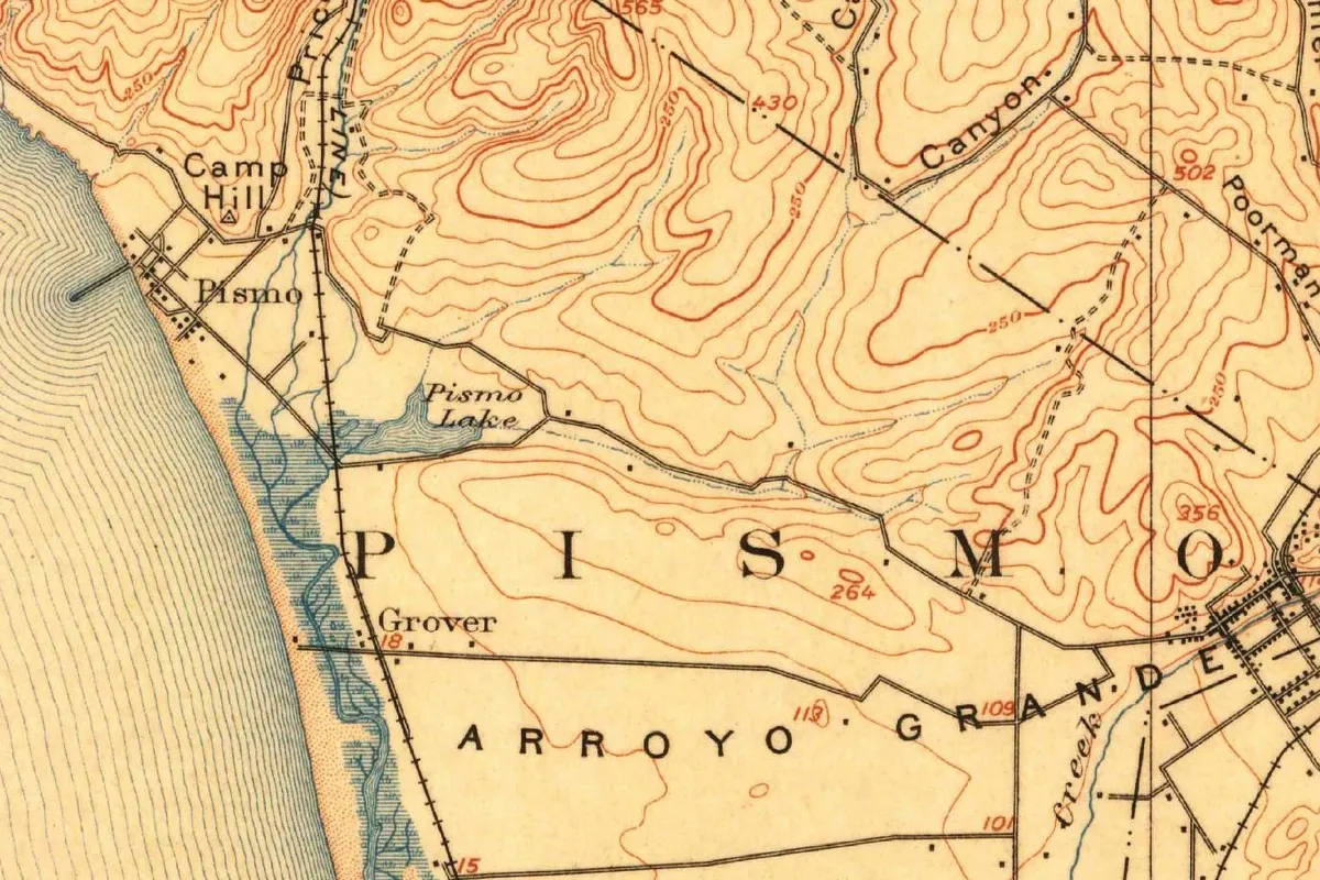
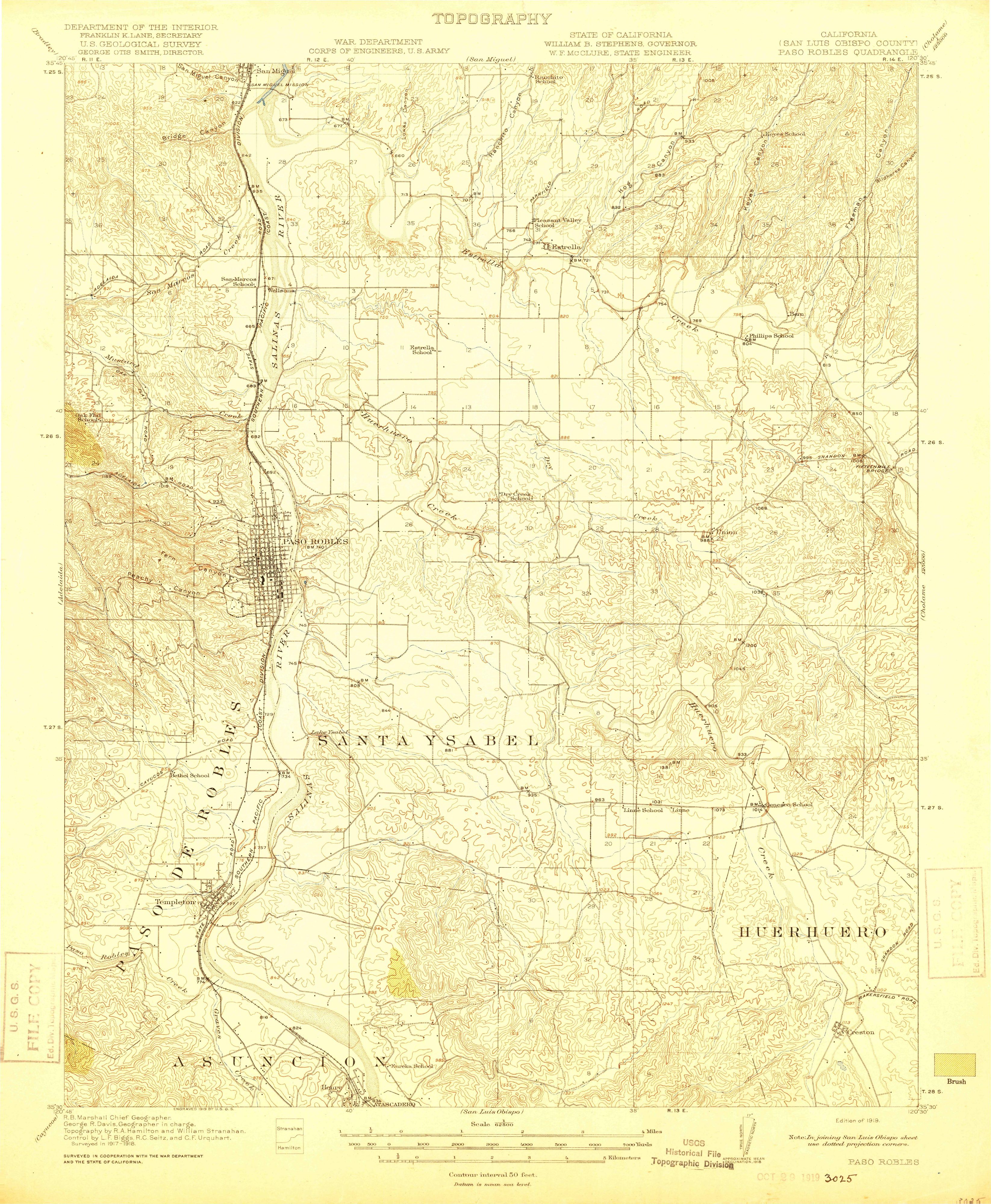
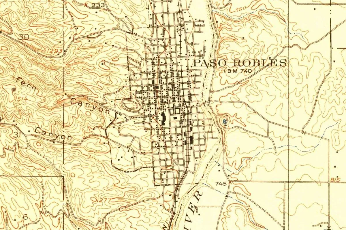
The map at the top comes from the Paso Robles sheet, surveyed in 1917-1918 by the Geological Survey in cooperation with the War Department and the State of California, and engraved in 1919. The copy scanned here is the edition of 1919, with no later printing marked on it. In the crop, you can see the town’s street grid labeled Paso Robles, set against the wide sandy bed of the Salinas River, with the railroad running beside it and Fern Canyon in the hills to the west.
The full sheet tells the rest of the story. The town is about halfway up its western third, and farther down the west side, below the town, past Templeton and Paso Robles Creek, the old land grant is lettered in big type with the full Spanish name: PASO DE ROBLES. Its neighbors on the sheet are other grants, Santa Ysabel, Huerhuero and Asuncion. So in 1919 the map already labeled the town without the “de,” while the old rancho kept it.
Quick answers
What does Paso Robles mean in English?
It means “pass of the oaks.” The full name is El Paso de Robles; Henry Gannett gave the meaning as “pass of the oak trees” in 1902, and Nellie Van de Grift Sanchez as “pass of the oaks” in 1914.
Does the city still use the name El Paso de Robles?
The city government still uses it. Resolution 20-117 of 2020 is titled as a resolution “of the City Council of the City of El Paso de Robles,” while the city’s history page says Paso Robles.
Which oaks gave Paso Robles its name?
Robles. Sanchez explained in 1914 that the roble isn’t the evergreen live oak, which Spanish calls encino, so the oaks of the pass were not the same trees as the encinos of Encinitas.
Who owned the land before the town?
The Paso Robles Rancho was granted to Pedro Narvaez and left to Petronilo Rios. In 1857 the Blackburn brothers and Lazarus Godchaux bought it for $8,000, and Drury James, an uncle of Jesse James, later became an owner of the springs.
Key dates
- 1795The year the city gives for the first talk of Paso Robles as California's oldest watering place.
- 1857James H. Blackburn, Daniel Drew Blackburn and Lazarus Godchaux buy the Paso Robles Rancho for $8,000.
- 1860The partners divide the rancho; Daniel Blackburn takes the hot springs and a league of land around them.
- 1886The first train arrives on October 31, and the Grand Auction of November 17 sells 228 lots.
- 1889Paso Robles is incorporated.
- 1891The three-story Hotel El Paso de Robles opens, along with a bathhouse over the sulfur spring.
- 1914Nellie Van de Grift Sanchez explains the name with Father Crespi's valley called Los Robles.
- 1919The Geological Survey's Paso Robles sheet, surveyed in 1917-1918, prints the town as Paso Robles and the land grant as Paso de Robles.
Things to do in Paso Robles, California
Paso Robles History Museum
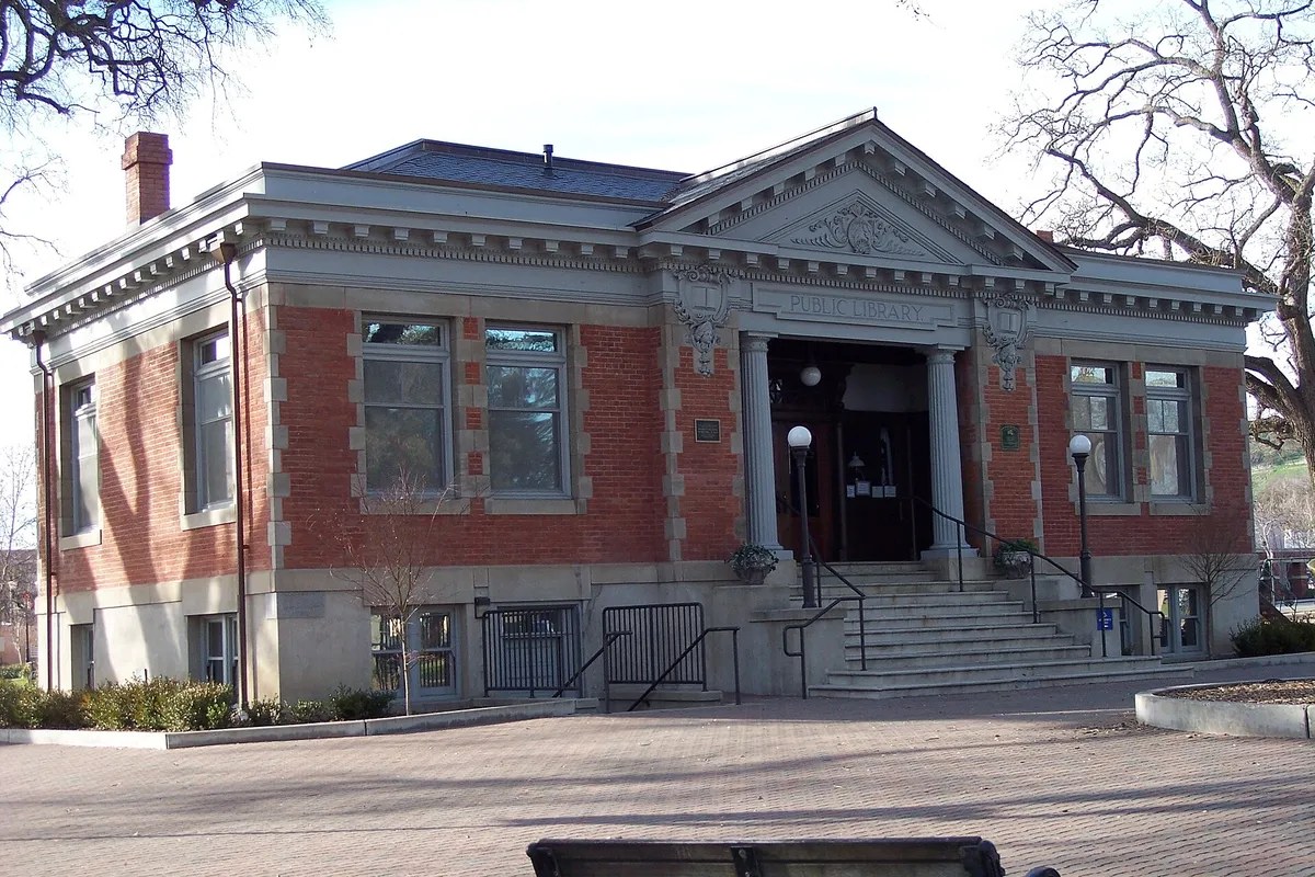
The local history museum of the El Paso de Robles Area Historical Society, upstairs in the historic Carnegie Library at the center of Downtown City Park.
Downtown City Park
A 4.8-acre (1.9 ha) park at 11th and Park streets on land the town's founders donated for public use, with a hexagonal gazebo at its center, a playground and picnic tables.
Paso Robles Pioneer Museum
A museum whose mission is to show life in a small California town in the 19th and 20th centuries, with cultural, agricultural and commercial artifacts from the area.
Estrella Warbirds Museum
A museum at the Paso Robles Municipal Airport, named for the former Estrella Army Airfield, with military aircraft, vehicles and memorabilia from World War I through the Gulf War.
Getting there
Open Paso Robles in Google Maps
Opens in a new tab. The pin is the center of Paso Robles in the USGS place-name record.
The closest airports, Amtrak stations and intercity bus stops, measured in a straight line from the center of Paso Robles.
Airports
- San Luis Obispo County Regional (SBP) 27 mi 44 km
- Santa Maria Public/Capt G Allan Hancock Field (SMX) 52 mi 84 km
- Mineta San Jose International (SJC) 138 mi 223 km
Amtrak trains
- Paso Robles station (PRB) under 1 mi 0.5 km
- San Luis Obispo station (SLO) 24 mi 39 km
Intercity buses
- Amtrak Chartered Vehicle Amtrak Connecting Service · Paso Robles Amtrak Station under 1 mi 0.5 km
- Gold Runner San Luis Obispo-Cal Poly 23 mi 36 km
- CLAS Amtrak Connecting Service · San Luis Obispo Amtrak Bus Stop 23 mi 37 km
Distances are as the crow flies, not by road. We don't list schedules or fares because they change; check with the airline, Amtrak or the bus company before you go. Official data (FAA commercial service airports (2025), FAA airport locations, Amtrak stations and Intercity Bus Atlas) from the FAA and the U.S. Bureau of Transportation Statistics, checked Nov 18, 2026.
Sponsored
Staying in Paso Robles?
Compare hotels in Paso Robles, California, on Expedia.
See hotels in Paso RoblesWe may earn a commission if you buy through this link. It never changes what we write. Read our affiliate disclosure
Historical Sources & References
- Nellie Van de Grift Sanchez, Spanish and Indian Place Names of California (1914), p. 124. “Paso de Robles (pass of the oaks),” the springs, “twenty-nine miles (47 km) north of San Luis Obispo,” Father Crespi’s valley “called Los Robles,” and the difference between roble and encino. Checked against the page image.
- Henry Gannett, The Origin of Certain Place Names in the United States (1902), p. 202. “A Spanish word, meaning ‘pass of the oak trees.’”
- City of Paso Robles, “History of Paso Robles”. The Salinan people, “California’s oldest watering place” and 1795, the rancho from Narvaez and Rios to the 1857 sale and the 1860 division, Drury James, the springs pamphlet, the train and auction of 1886, incorporation in 1889 and the hotel of 1891.
- City of El Paso de Robles, Resolution No. 20-117 (2020). The heading “Resolution of the City Council of the City of El Paso de Robles.”
- Downtown City Park; Paso Robles History Museum; Pioneer Museum; Estrella Warbirds Museum. The details in the things-to-do list, and the founders’ gift of the park land.
- GNIS feature 254139. The Geological Survey’s listing of Paso Robles as a populated place in San Luis Obispo County, and its coordinates.
- Paso Robles sheet, surveyed 1917-1918, edition of 1919. The sheet the map at the top was cropped from, with topography by R. A. Hamilton and William Stranahan under R. B. Marshall, engraved by the Survey in 1919.
Sponsored
Put this 1919 map on your wall
The Geological Survey's 1919 Paso Robles sheet, where the old land grant's name, Paso de Robles, still runs down the west side below the town, is in the public domain. Download the full-size scan for free, then have it printed on canvas with CanvasOnTheCheap.
Print a map on canvasDownload the full-size mapWe may earn a commission if you buy through this link. It never changes what we write. Read our affiliate disclosure
Spot something wrong, or know more? Tell us here. You can also email us or use our contact page. Corrections are noted here with their date, never made silently.