What Does Pagosa Mean? Healing or Boiling Waters
Pagosa comes from the Ute word pagosah, but sources translate it differently. The Town of Pagosa Springs calls it a Southern Ute word for healing waters, a federal preservation page gives healing or boiling waters, and a 2021 report for the town says boiling waters. Springs refers to the hot spring itself.
Pagosa Springs, Colorado, is named for a hot spring the Utes called pagosah, but the sources don’t agree on whether that means healing or boiling waters. The “Springs” part is easy. It’s the first word that you’ll see translated three slightly different ways, depending on who’s doing the translating.
Three translations of one word
Start with the town itself. On its “About” page, the Town of Pagosa Springs calls the place a community known for its “healing waters,” and adds that “‘Pagosah’ is a Southern Ute word for ‘healing waters.’”
A federal page hedges. The Advisory Council on Historic Preservation, which recognized the town in its Preserve America program, says the name “Pagosa” was derived from the Ute word “Pagosah” meaning “healing or boiling waters.” It adds that the Utes believed the springs had healing and curative powers.
A third source drops the healing part. In December 2021 Ruth E. Lambert of Blue Canyon Cultural Consulting wrote an assessment of the town cemetery for the Town of Pagosa Springs, and on page 7 she mentions “the well-known hot springs, Pagosa Springs (meaning ‘boiling waters’ in the Ute language).”
So which is it? None of these sources quotes a Ute speaker or a Ute dictionary, and none explains how it got its translation. You can read “healing or boiling” as a way of keeping both. Either word fits a spring this hot, and this page won’t pick one for you.
Colorado has another hot-spring town with a Ute name for its water. In Glenwood Springs, the Utes called the springs Yampah, which that town’s sources translate as “big medicine.” And far to the northeast, an 1899 history of Hot Springs, South Dakota, wished the town had gone with Minnekahta, the Sioux name for its warm water. Out west, Caliente, Nevada, took a Spanish name for the same kind of water: the city says it became Calientes, “the Spanish word for hot,” after hot springs in a cave at the foot of the mountains.
“The Pagosa” in 1859
The word was in use long before the town. In the summer of 1859 an Army expedition under Captain John N. Macomb was looking for a route between New Mexico and Utah. Macomb’s own report to the War Department, printed by the government in 1876, calls the place “the ‘Pagosa,’ or great hot spring,” as though the spring alone carried the name.
The expedition’s geologist, J. S. Newberry, kept a journal, and his entry for July 28 is headed simply “Pagosa.” He wrote:
“In the upper part of this valley is the Pagosa, one of the most remarkable hot springs on the continent, well known, even famous, among the Indian tribes, but, up to the time of our visit, never having been seen by the whites.”
He thought it could hardly be doubted that “in future years it will become a celebrated place of resort,” and he added, “There is scarcely a more beautiful place on the face of the earth.”
He described a great oval basin, “40 by 50 feet in diameter,” about 12 by 15 m, “in which the deep-blue water seethes and surges as in a boiling caldron, giving off a column of vapor which in damp weather is visible for miles.” On the next page he measured the water at 140 degrees at the side of the basin, about 60 °C, and noted that it wasn’t actually boiling; the bubbling came from gas. Newberry didn’t translate the word at all.
A road, a townsite and a fort
The next year, according to Lambert’s report, Charles Baker formed the Abiquiu, Pagosa, and Baker City Road Company in 1860, on the way to the San Juan gold country. She reads the name of the road as a sign that Baker knew the spot, “most likely from Indian use of the hot springs rather than any settlement in the area.”
Lambert also notes that the Brunot Agreement of 1874 permitted legal non-Indian settlement in the San Juan Mountains. The same agreement is a big part of the story in Ouray, named for a Ute leader whose treaties cost the Utes land. By 1876, Lambert writes, settlers were building cabins near the springs. On May 22, 1877, a presidential order created a townsite one mile (1.6 km) square, centered on the hot springs. A post office opened in June 1878.
That fall the Army moved in. On October 15, 1878, troops from Fort Garland arrived, and a few days later the post was named Camp Lewis for Lieutenant Colonel William Lewis, who’d recently been killed in Kansas. The town’s cemetery page says the post moved in January 1881 to the Rio de la Plata, near Durango.
The springs themselves had been fought over. The preservation council says ownership of the hot springs was a source of conflict between the Utes and the Navajos until the federal government formally claimed them in 1880. The town was platted in 1883 and incorporated in 1891.
Pagosa Springs on the 1927 map
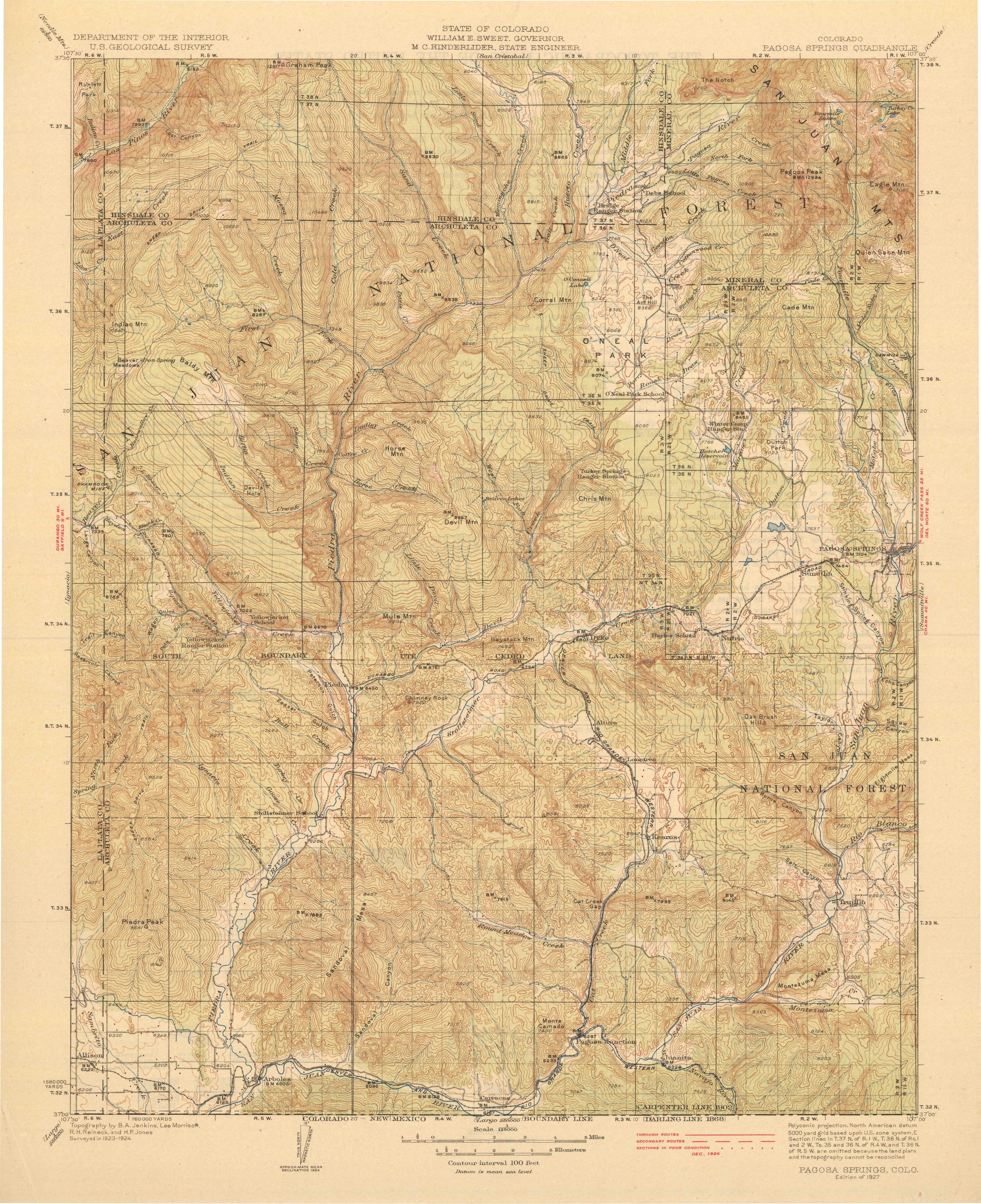
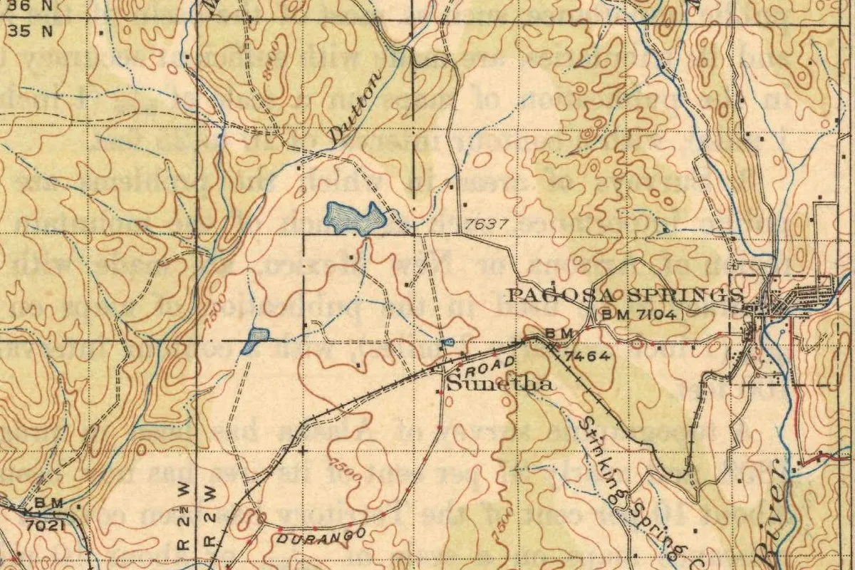
The map at the top comes from the Pagosa Springs sheet, which the Geological Survey and the State of Colorado surveyed together in 1923-1924. The copy scanned here is the edition of 1927, with no later printing marked on it. The town sits near the east edge of the sheet, so the crop runs right up to the border. You’ll see the label “Pagosa Springs” with a bench mark of 7,104 feet (2,165 m), and just to its right the town’s streets inside a dashed square, with the San Juan, marked simply “River,” running past. A railroad comes in from the west, and a road is marked “Durango.”
Quick answers
What does Pagosa mean?
It depends on the source. The Town of Pagosa Springs says pagosah is a Southern Ute word for “healing waters,” the Advisory Council on Historic Preservation says “healing or boiling waters,” and a 2021 report for the town says “boiling waters.”
Is Pagosa a Ute word?
All three sources quoted here say so. The word was already attached to the hot spring in 1859, when the Macomb expedition’s geologist called it “the Pagosa” and said it was well known among the Indian tribes.
When was Pagosa Springs founded?
A presidential order created the townsite on May 22, 1877, and a post office opened in June 1878. The town was platted in 1883 and incorporated in 1891.
What was Fort Lewis in Pagosa Springs?
An Army post set up at the springs on October 15, 1878, first named Camp Lewis. It moved near Durango in January 1881.
Key dates
- 1859July 28: the Macomb expedition reaches the hot spring its geologist calls the Pagosa.
- 1860Charles Baker forms the Abiquiu, Pagosa, and Baker City Road Company.
- 1876Settlers are building cabins near the springs.
- 1877May 22: a presidential order creates a townsite one mile (1.6 km) square, centered on the hot springs.
- 1878A post office opens in June, and federal troops arrive on October 15 at the post soon named Camp Lewis.
- 1880The federal government formally claims ownership of the hot springs.
- 1883The Town of Pagosa Springs is platted.
- 1891Pagosa Springs is incorporated.
Things to do in Pagosa Springs, Colorado
The Mother Spring
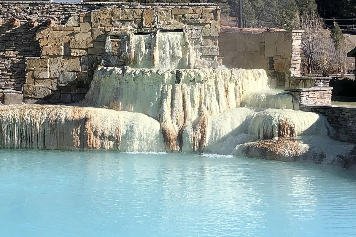
A hot spring in town, which the visitor center says is the world's deepest geothermal hot spring aquifer, certified by Guinness World Records, at a depth of more than 1,002 feet (305 m).
Pagosa Springs History Museum
A downtown museum with local historical items, many of them donated by pioneer families who have lived in the area for generations.
Chimney Rock National Monument
An archaeological site seen on tours, with a Chacoan Great House Pueblo at 7,600 feet (2,316 m), a 44-foot (13 m) excavated Great Kiva, a pit house and views over the Piedra River valley.
San Juan National Forest
The national forest around town; its Pagosa Ranger District alone manages 585,770 acres (about 237,000 ha) across Archuleta, Mineral, Hinsdale, Conejos and Rio Grande counties.
Getting there
Open Pagosa Springs in Google Maps
Opens in a new tab. The pin is the center of Pagosa Springs in the USGS place-name record.
The closest airports, Amtrak stations and intercity bus stops, measured in a straight line from the center of Pagosa Springs.
Airports
- Durango-La Plata County (DRO) 42 mi 67 km
- San Luis Valley Regional/Bergman Field (ALS) Alamosa 64 mi 103 km
Intercity buses
- Bustang Outrider Bustang · Bayfield 32 mi 52 km
- Greyhound Durango W 8th St 48 mi 77 km
Distances are as the crow flies, not by road. We don't list schedules or fares because they change; check with the airline, Amtrak or the bus company before you go. Official data (FAA commercial service airports (2025), FAA airport locations, Amtrak stations and Intercity Bus Atlas) from the FAA and the U.S. Bureau of Transportation Statistics, checked Nov 18, 2026.
Sponsored
Staying in Pagosa Springs?
Compare hotels in Pagosa Springs, Colorado, on Expedia.
See hotels in Pagosa SpringsWe may earn a commission if you buy through this link. It never changes what we write. Read our affiliate disclosure
Historical Sources & References
- Town of Pagosa Springs, “About”. “‘Pagosah’ is a Southern Ute word for ‘healing waters.’”
- Advisory Council on Historic Preservation, “Pagosa Springs, Colorado”. “Healing or boiling waters,” the Ute-Navajo conflict over the springs, the federal claim of 1880, platting in 1883 and incorporation in 1891.
- Ruth E. Lambert, Archaeological Assessment of the Pagosa Springs Cemetery (2021), pp. 7-8. “Boiling waters,” the Macomb expedition, Baker’s road company of 1860, the Brunot Agreement, the cabins of 1876, the townsite order of May 22, 1877, the post office of 1878 and Camp Lewis.
- Town of Pagosa Springs, “Pagosa Springs Cemetery”. Fort Lewis at the springs from October 15, 1878, until its move near Durango in January 1881.
- J. N. Macomb, Report of the Exploring Expedition from Santa Fé (1876), pp. 5 and 74-75. “The ‘Pagosa,’ or great hot spring” on page 5, and Newberry’s entry of July 28, 1859, with the basin “40 by 50 feet” (12 by 15 m) and the temperature of 140 degrees. Page 74 checked against the page image.
- Visit Pagosa Springs, “Geothermal”; “Discover Pagosa Springs”; Chimney Rock; San Juan National Forest. The details in the things-to-do list.
- GNIS feature 184338. The Survey’s gazetteer entry for Pagosa Springs, a populated place in Archuleta County, with its coordinates.
- Pagosa Springs sheet, surveyed 1923-1924, edition of 1927. The sheet the map at the top was cropped from, with topography by B. A. Jenkins, Lee Morrison, R. H. Reineck and H. P. Jones.
Sponsored
Put this 1927 map on your wall
The 1927 Pagosa Springs sheet, surveyed in 1923-1924 by the Geological Survey with the State of Colorado, is in the public domain. Download the full-size scan for free, then have it printed on canvas with CanvasOnTheCheap.
Print a map on canvasDownload the full-size mapWe may earn a commission if you buy through this link. It never changes what we write. Read our affiliate disclosure
Spot something wrong, or know more? Tell us here. You can also email us or use our contact page. Corrections are noted here with their date, never made silently.